

forkyfork
-
Posts
29,977 -
Joined
-
Last visited
Content Type
Profiles
Blogs
Forums
American Weather
Media Demo
Store
Gallery
Everything posted by forkyfork
-
had this happened later in the summer we all would have gotten hit
-
here's the reason for the bust. drier air just offshore. credit to hm for seeing it
-
gigo
-
8 now
-
1-3+ in this zone over the next few hours imo
-
would be nice to get an hrrr initialization that's accurate
-
the outflow boundary is sinking south and we'll start to fill in shortly
-
if you read the latest meso discussion that's exactly what they describe happening
-
"wahh it's not flooding here" posts are getting deleted from now on <3
-
every run of the hrrr edges a little more southeast
-
you're not getting missed
-
the 3k hits the metro with a secondary low later tonight
-

Extended summer stormlover74 future snow hole banter thread 23
forkyfork replied to BxEngine's topic in New York City Metro
i'm telling randy to take your powers away -
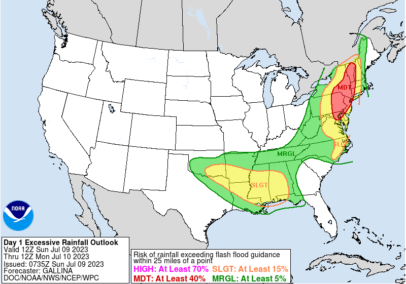
this looks significant enough for its own thread By evening instances of 3-6" locally will become increasingly plausible with 00z HREF probability fields greater than 60% from DC to N VT (with spots near 90-100% for 3" and 30-60% of 5" across NE PA/N NJ to S VT. 00z Hi-Res CAMs have trended slightly eastward to align more favorably to the greatest 14-day precipitation over 300% of climatological normal axis extending from near Baltimore to Philly to N NJ and W MA, suggesting increased runoff potential for these. As the surface wave advances toward the New York Bight by early morning, increased low level flow, will advect unstable across across S NY/New England and with continued isentropic ascent through warm conveyor belt along/north of the surface low, additional efficient thunderstorms a likely to linger overnight, in proximity to SE NY/SW New England as well as into south facing terrain making a more likely scenario for flash flooding. As such, the Moderate Risk of excessive rainfall was shifted eastward slightly to account for the guidance trends.
-
hooray
-
whenever we get a ridge bridge it's going to be awful. i genuinely don't want it
-
not one below normal 850mb panel on the entire run of the eps
-
next week might be rushing it but i think we start breaking off some of the western heat within the next 10 days
-
first 100s of the summer next week?
-
three
-
our cold water nightmare is over
-
ewr is now two 90s ahead of july 2009
-
storms fired early enough to organize despite the worsening upper levels
-
we deserve this
-
this it the 4th time i've gotten hail this summer


