

buckeye
-
Posts
8,771 -
Joined
Content Type
Profiles
Blogs
Forums
American Weather
Media Demo
Store
Gallery
Everything posted by buckeye
-
It kind of kills all the hype about comparisons to the great MW outbreaks, when it can't even penetrate south of i-80? It looks like record breaking coverage will be limited to the immediate great lakes area.
-
euro now has our coldest temps coming in only at around -3 or 4. zzzzzzzzzzzz what an absolute overhyped joke this is turning out to be, this may not even end up as cold as the period we had a week or so ago.
-
I can see both sides of the OH/jbcmh discussion. But taking into account the venue in which the debate is taking place....I feel jbcmh has the winning point. What I mean by that is OH is trying to tell a group of weather weenie enthusiasts that 'technically' they have nothing to complain about. That's like telling a group of rabid OSU fans that they have no right to be disappointed by a 10 and 2 season. It might be true that on paper we're doing fine and are close to climo. Problem with that argument is the choir you're preaching to worships to a different god than climo. No one who reads or participates in this forum is rooting for climo to be reached. We all have day jobs and wouldn't waste our time posting and participating here, or staying up until 1am for a euro run, if we were just seeking to reach climo every year via nickles and dimes. We're already very good at that. We are all ultimately in search of something 'memorable' to happen each winter. Something that 10 years from now would make a top 10 list. It really has been quite awhile since we had that. My last truly memorable event was not a single event, but a stretch of weather that occurred in Feb of '10. That was 9 years ago. We have had a couple of decent storms since than, but nothing I can etch in granite as a singularly memorable event. With that in mind, this winter has been miserable. Expectations were built up tremendously. Most of us in the southern areas of the sub missed the single event for the sub in Nov and we were all shut out in December. Than our usual nickel and dimes showed up in January followed by a storm that was surprisingly disappointing for what could, (if not should), have been, (OH even admitted so). Now we sit on the cusp of a possible record breaking artic intrusion while being forced to stay inside and look out the window at frozen mud and crispy grass. The so-called clipper that once looked like an arctic boundary snow storm, (on the medium range euro), morphed into a clipper that doesn't even make it south of Chicago before hanging a left into the lakes and missing the entire state of Ohio. Now, as we find ourselves in the midst of what JB once referred to as the climax of this severe winter, (Jan 20 - Mid Feb), we already have a several day stretch of warm weather showing up right smack in the middle of it. So then what's next? Who knows? I believe nothing, no model, no forecasters, no indices. I expect nothing for the rest of winter ...fending off disappointment and inviting only surprise.
-
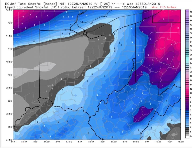
Last Friday, the euro depicted CMH receiving 27 inches of snow by tomorrow, (Monday), with temps in the - teens as well. The failure and constant stepping back of any and all winter threats has been brutal this season. The euro now has us getting a tenth of an inch of snow over the next ten days, (that not qpf, it's snowfall). That might be the worst 10 day euro snowfall run for us since December.
-
I'm with ya. HATE back loaded winters. Last March and April were nightmare scenarios.
-
Models have been really bad this year in the medium and short range. That includes the euro. We didn't really fail last weekend but it was once again one of those 'near misses' where literally a degree or two in the mid levels would have made the difference between a snow event vs. something much more memorable. We've also had to endure outstanding storm tracks where the only ingredient missing was enough cold air. Then we have one of the coldest air masses in several years dropping in and the clipper that preceeds it makes a quick hook and rotation to our nw leaving us with prefrontal rain to nothing. We failed in 3 ways on that one situation, (clipper track, anafront snow, and a wave on the front). It looks like our next snow chance could be a squall that could develop on the leading edge of the coldest incoming air on Wednesday. It's not really showing up on the models yet, but I've seen that happen in the past. After that a return flow on the departing cold yields some waa snows according to some of the models, (friday timeframe). Then we rain and wait for our next shot. So far this has been a forgettable winter*...nothing that will stick in my mind in future years. Let's see what happens with this incoming coldshot. * laughs outloud at all the 'winter of yore' calls.... winter of 'bore'
-
Yea, speaking of mon/Tues, euro has virtually little to no precip for us with the clipper passing north and the front speeding by. The cold shot is also somewhat muted and shortened. This winter now has that imminent feeling of failure from here on out no matter what fantasies the models might conjure up in the mid to long range.
-
yep... ....have no doubt, big dog first week of April...that's how we roll in Cbus
-
I'm pretty much on your page. I also would take mid 20's and solid snowcover over record cold and bare ground everytime. But if we're gonna be miserable, maybe we can knock out a record or two doing it.
-
looks like we're back to the good ole indy-cmh screw zone. I guess the only good news is that's probably about the worse case scenario for us.... and being 4 days out it can only change for the better? right? maybe?
-
blech, looks like euro backed off of the frontal wave, (at least for our area), looks like it goes further east. Not really surprised though. As far as the brutal cold outbreak, I'd rather have it with a snow cover....if we're gonna do it, might as well go all out. Bare ground and -10 when it could have been a snowcover and -20 kinda sucks lol.
-
Icon is close, but it's a much better hit for far eastern OH... low is a little too far east. (that's another possible bad scenario with this).
-
looks similar to the 00z euro. Hopefully trend continues. Our worst case scenario is if things start trending south again with the clipper and we end up back to where we were with a clipper going through northern OH bringing up enough warm air for rain showers and then a windy changeover to snowshowers.
-
6z gfs is moving more towards that look, although it's snow is still primarily anafrontal. At 5h the 6z euro and gfs have a similar orientation and shape of the PV but the euro keeps more energy in the sw allowing heights to rise in the east. The gfs bundles most of the energy in the ns and so the precip focus is strictly on the front. It's no longer about rooting for a southern trend to the clipper, (that ship sailed anyways). Now we want the opposite to happen, a further north and weak clipper. The PV diving south through the northern plains will have a better chance to deepen and sharpen the trough with the clipper out of the way. That should slow the front and hopefully gives us a shot of having something spin up it.
-
Euro isn't bad. It has a different way of giving us snow. Sends the clipper from Chicago to Detroit with not much precip at all for us from the actual low. But then develops a low on the front that goes from AL to KY, which is how we get our snow. Something to watch for in future runs. We might actually be better off with a further north low to allow enough space and timing for a scenario like that to play out.
-
Yea, this one favors north, and warm air being drawn up,in front.... but hopefully not as snowless and rainy as the gfs is showing. Euro OP at least shows how we can still score down here even with rain being part of the mix.
-
True, ....plus after this past weekend it's clear that model solutions can definitely change once the energy is sampled. ( I use to think that was just weenie desperation).
-
Hope the gfs is wrong....that would be a really insulting way to usher in a record cold outbreak.
-
GFS did come south a bit from 00z... but it's still way north of the euro.
-
HRRR fairly 'bullish' (relatively speaking) for tonight's changeover. Shows changeover starting around 10 or 11pm
-
I'm ok where we are right now as depicted. I could see this trend more favorably, not just in terms of the track, but how it all comes together with the potential for something stronger on the font, south of us. I could be wrong but I don't see this as a straight rain, to backlash flurries event.
-
actually think the evolution is better than 00z. Has more emphasis on moisture along, behind the front. That would be like a brief period of rain and mix followed by a nice thump to bring in the arctic air.
-
Euro gives us a couple of inches about an inch tonight? Also, it give us a few inches wrt Monday's clipper, mostly as a result of a 'wavy' front once the clipper goes north. Something that could evolve better for us. Also fwiw, gefs is much further south than the op. Definitely a 'trackable' event. Hopefully if we are going to get the brutal cold being advertised, we can get at least a few inches of snowcover down.
-
so you're not buying next weeks widespread double digit below zero readings across the forum?
-
gfs and gem still north with the mon clipper. A lot depends on the orientation and how the PV rotates as the storm rides around the edge out of the north central states. Still a lot could change in 5 days, and the old 'bullseye' rule applies. That's one hell of a brutal air mass on it's heels. I'm having a hard time believing it's going to cut up towards north east OH with that air mass.... but of course that's probably the weenie in me talking.


