

buckeye
-
Posts
8,771 -
Joined
Content Type
Profiles
Blogs
Forums
American Weather
Media Demo
Store
Gallery
Everything posted by buckeye
-

Winter 2021-22 Short/Medium Range Discussion
buckeye replied to Chicago Storm's topic in Lakes/Ohio Valley
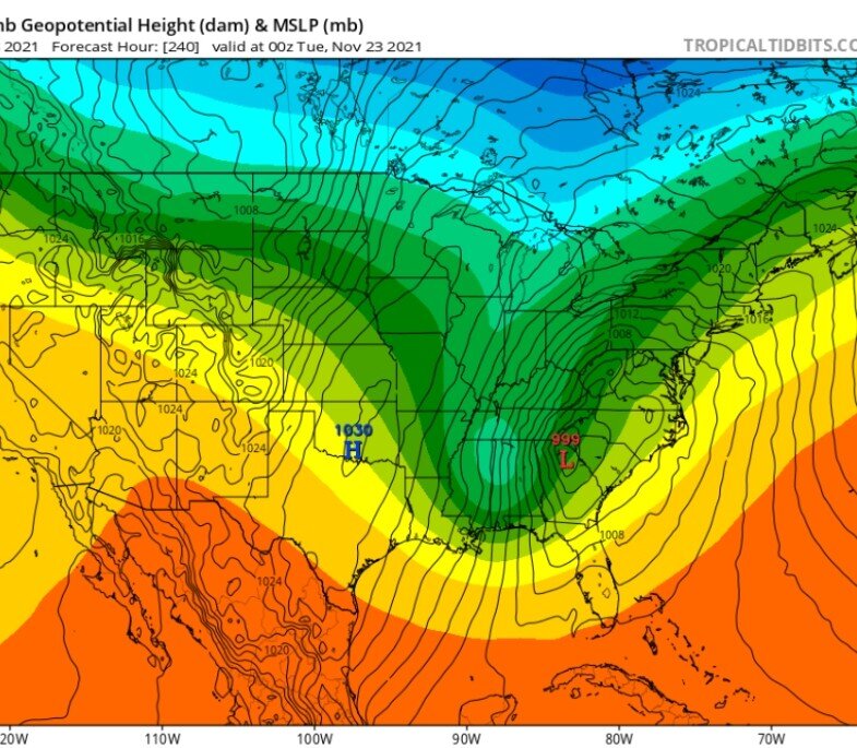
240 hr - yea, yea I know but nice look....Hard core blocking would keep it from cutting. Normally I wouldn't be rooting for early snow but we've been so damn busy that I'd gladly take a weather delay at this point.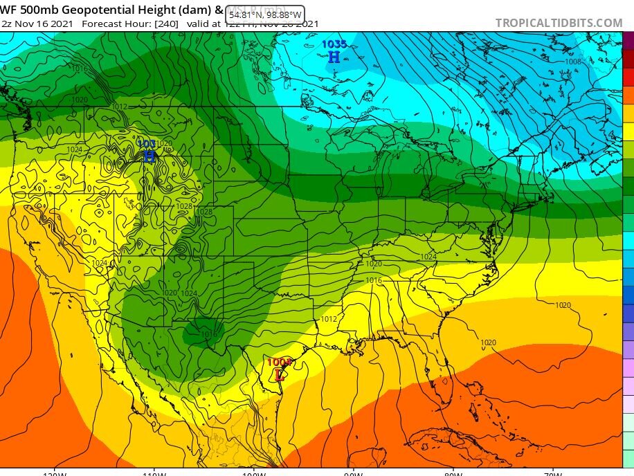
-
Can we have this map 24hrs out in the dead of winter with antecedent Arctic air? Lol, of course not.
-
Temperate and moist
-
TAM
-
Wife and I went up to Mackinaw Island over the weekend. A few observations: 1. I thought Ohio drivers were terrible, Michiganders say, "hold my beer". Once we got north of Brighton it was like the autobahn. I was going 95mph and didn't realize it because so was everyone else. That wouldn't have been a bad thing except for the fact that it would go from 95 to stopped traffic and back to 95 for no apparent reason. 2. Roads were in rough shape. 3. Mackinaw was beautiful.... never seen water that clear and blue outside the Carribean.
-
Hopefully we'll have a lot to talk about. With an Almanac forecast of "icy, flaky", what can possibly go wrong!
-
Hopefully a weak one
-
All short range guidance from last night and early this morning has been horrendous. Virtually every model I looked at last night and early this morning showed the precip shield that came into OH from N. IN and S. MI dissipating well before it made it to central OH. As I type this, it's torrential rain here and the thunderstorm line will go through Cincinnati.
-
I wonder if that was before midnight and the additional will show for today? Otherwise they are off their rocker
-
Like most others here in Ohio, looks like we got between 3 and 4 inches. Somewhat of a bust for local wx guys who called for .5-1"
-
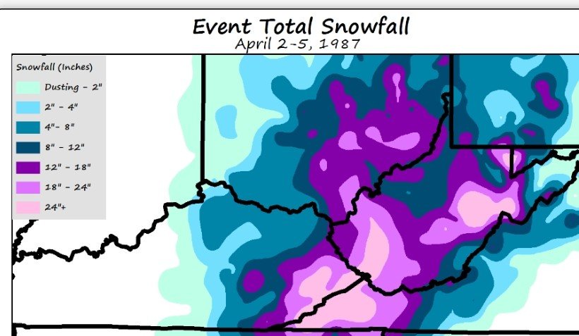
I remember this one very well. A foot of snow that disappeared in 24 hrs.
-
For us 'normal' weather weenies who look to April for the beginning of warmth and severe season, it's never good to see Josh start posting.
-
Hopefully it's just another case of the canadian being the canadian but it shows us going into the single digits latter half of next week. After this week that's going to feel even worse than it sounds.
-
I do agree that the general (non-wxweenie) public is clueless with pretty much all watches, advisories, warnings and their meaning, so anything that simplifies is probably best. I can't count the number of times I've heard media wx personalities, (much less general public), say things like "winter storm advisory" or "winter weather watch".
-
Back in the day they didn't have winter weather advisories, instead it was called a traveler's advisory (which I think made more sense). Most advisories are issued as a result of the effect on travel anyways. If you're not really going anywhere, 1-3 or 2-4 inches of snow isn't going to make much of a difference in your life.
-
Morch
-
The clipper drought in recent years has definitely been strange.
-
It's all relative and perception....and of course personal preference. But you kind of make my first point by asking if we've even hit normal snowfall yet when we are currently about 30% above normal. Our climo is such that typically we nickle and dime our way to normal with light snowfalls that disappear in a few days....every once in awhile we get a true snowstorm thrown in there. What are CMH's chances of not only having a white Christmas, but having accumulating snow on Xmas Eve and day? What are our chances of having a solid snow cover with intermittent refresher for more than 2 weeks? Those two things happen rarely but even more rarely in the same winter. The winter storm sucked if you're a snow stat lover, but it was still a disruptive winter storm that was fun to track and gave us a bulletproof snow cover. I think we romanticize and exaggerate past winters....I know I'm guilty of that. I think its because we tend to lump events and memorable times together instead of looking at them for what they were, isolated events often spread out by years. All that being said winter 77-78 was the benchmark A+ winter in my lifetime for many different reasons not just the blizzard. I could probably be arm twisted into dropping to a B+ if we don't see another flake, but for now I'll stick by my A-. (I don't want to insult the weather Gods ) . I suspect with your standards we may all be dead before a Dilly-B rated or above winter happens again
-
We had a neg nao/ao and epo. MJO was in warm phase and the pna was negative though. Looking ahead though, there really isn't any indice that points to cold. Ao, nao, epo, all positive and pna neg. MJO still circling in COD or warm
-
Looks like the fat lady has approached the microphone for winter 2020-2021. Every indice I've seen is showing a warm signal moving ahead thru March. I might be a little early here but even if we don't see another flake of snow, I'm giving this winter an B+/A-. It's all relative but here are my thoughts, -Christmas eve/day snow -Multi-week snow cover -Avoided insanely cold temps -Insane block allowed us to avoid cutter city (considering it was a nina winter) -Yea, I know....what about the sleet storm and what could have been? Oh well, was still our first winterstorm in awhile and was fun to track. Granted, had that been all snow I might have had to go with an A+ . -Let's not forget, we would have killed for similar stuff the last few winters.....as I said, it's all relative.
-
Entering least favorite time of year....mud and 40s season. Could be a wild spring though.
-
It's kinda funny, not picking on anyone, but there's always been a sense of competition on this site. It's as though there's a skill set involved with ending up with the most snow.
-
Oh hell no, I'm still applying burn cream from yesterday.
-
It's funny we all called it a NW trend with the last storm, but it was more like a NW pop. It literally unfolded during the storm. I said I'd take my chances any day with a storm that rode from AL to central WV and east....but it got to WV and nudged into eastern OH, bringing the wtod with it. It really sucks when you can't trust models 24 hrs out. We rarely benefit from NW trends but the most infamous one that we did was PD03. After the first wave came through the second bigger wave was supposed to be a miss south. I checked I remember checking the.18z models that Saturday evening and everything had suddenly shifted central OH into the game and that was less than 24 hours out.
-
Our snow pack probably has more staying power then some of the deeper snow pack further NW. High water content and layers of frz rain/sleet mixed in. High ratio snow is great but it disappears more quickly. I'd still rather have the high ratio stuff though.


