

buckeye
-
Posts
8,771 -
Joined
Content Type
Profiles
Blogs
Forums
American Weather
Media Demo
Store
Gallery
Everything posted by buckeye
-
I think we got nam'd
-
Damn, I always miss the fireworks
-
That's right Steve is from Newark. Well at least apple valley is more east then Columbus.
-
Where's Angry been?
-
Dilly, are you still in Newark?
-
Fair enough... 4-7" 5.87"airport
-
I'm not gonna guess inches, but I feel pretty good about this one. Looking at everything on the 18gfs other then the precip shield position, it trended favorably including it's ens. I started optimistic on this and I'm riding to the end
-
the 2 models I think worth watching the most now are the rgem and the nam, both of those at 18z came in pretty nice for our area.
-
the snow amounts in the snow shield are so randomly placed, I wonder if that has to do with temp issues. It's not just the nam either
-
just keeping it real but hoping for that small bump west in the last 36 hrs that often happens especially in a setup like this. if there was an arctic high behind it pushing in id be more concerned with an east bump. but we'll see
-
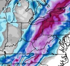
Although we're riding the edge in Columbus, we are pretty likely to get our first 2+" snowfall of the season. We're going to continue to go back and forth because of where we are situated. We're not just in the game, we'll be going into overtime. As far as the HRRR, it's not just a joke beyond 12 hours, it's typically a joke beyond 3 hours. That said, it shows a 985 low over the eastern panhandle of WV, I'd take that any day.
-
18z euro nice shift west
-
rgem is a little better which might mean the ggem comes back around tonight
-
pretty much yea....nam +48 18z run...that's usually when someone gets nam'd, we got null'd. Long way to go

-
I'd say overall very slight changes for better today. Biggest disappointment was the ggem which was a near miss east for central OH and a small jump east with all the 500mb features. Sunday morning the closed low will be over the southern states. Gonna be a nailbiter the next 2 days. Have to dust off all the mesos and issue a radar hallucinations watch...conditions will be favorable.
-
nam came in with a much better phase, pulling things further west.
-
Weather has a way of balancing itself out even if the timing of how that happens can suck. I hope you guys get your "March'08" except in Jan or Feb....fully aware that would require a low passing over Columbus and us having to take one for the team. (notice I said ONE, let's not get crazy)...I'm not that generous
-
For who? Indianapolis? , yes which sucks because they have been screwed worse than us and I have a soft spot for our I-70 brethren. For Columbus?....maybe if your idea of the game is getting the brunt of a storm, but for me, where we sit now IS what the game is all about. 48 hours out and riding the western edge of an incoming storm from the south with a positive nao heading neutral and no fresh arctic air mass pushing behind it during a la nina.... I'll take those odds. I think we at least get some accumulation, I'd be really surprised if Franklin county is relegated to smoking cirrus, but who knows, the game ain't over yet.
-
Damn, rgem is a wv crush job. Would love to be in Morgantown if that verified.
-
smarta**
-
I was wondering what jb was thinking. I actually don't have a subscription. I'm sure he was using March '93 as his analog.
-
I know the nam 48+ and the icon are the Larry and Mo of the model suites but it's interesting that they both came dramatically nw for the same reason ...better phasing with the northern stream. Have to wonder if some new data is involved and a legit trend or just another head fake.
-
Also, I've been following these boards for 20 years. 99% of app runners start off modeled as an eastcoast snowstorm....including March 8. They also never get the lead time that the coasters get. Usually the concensus comes in the final 48 hours. let's just say I topped off my half empty glass
-
I don't either. Think of it this way too, this is the second phase of the hybrid storm in the main thread....there still isn't really good model concensus on that. Kinda puts things in perspective. We need to let this playout for another 48 hrs (when it starts to take shape over the gulf states).
-
Looks like euro went east some, but still decent for eastern half of Ohio. Biggest change I noticed was the southern vort moving much quicker and taking the turn north a little further east. Ironically still ends up over DC. Overall pretty much everything stayed the course today. Someone said new data comes in later today? Maybe we'll start to see a swing one way or the other by tomorrow.


