

buckeye
-
Posts
8,771 -
Joined
Content Type
Profiles
Blogs
Forums
American Weather
Media Demo
Store
Gallery
Everything posted by buckeye
-
ukmet is really progressive, actually takes the storm that forms on the front east of us and whiffs us. The uk has been pretty progressive all season though I remember it use to be the model that would bomb out every storm in the 6 day range.
-
the 12z gfs is our nightmare and the 12z ggem is our dream. Provides a perfect window into what we need to happen and what we hope doesn't happen. GGEM is trending stronger with the high pressure and push south, it also holds back the sw more and strings it out. GFS sends out more of a consolidated sw and has a weaker northern stream. Trying to stay completely unbiased I think in a set up where a positively tilted trough with a pressing arctic high is going to be more likely to trend towards a southeast push. We really haven't had a storm with a pushing arctic high yet this season. The one last weekend was on the backside of the high and that kept it more west. Still a lot of moving parts and I honestly don't think we'll have even a general idea until monday 00z and even then it's still 2-3 days out. fun one to track though no matter what happens
-
150 hrs out.... doubt this is how it ends up. Then again the low could end up over Indy by then actually still feeling good to score something out of this in spite of the op runs. It'll be interesting to see if the euro does that thing where it goes east at 00z and west at 12z. Seems to do that for some reason.
-
Seems like it's pushing back in time. This was originally a Monday Tuesday event now it's next Wednesday Thursday. The icon does what you're referring to with two storms. The ggem is more like the gfs with us mostly rain. 144 hrs out has a low over cle. We got a long way to go with a lot of model head fakes ahead, good and bad. Today's mjo is now going from cod right into phase 3 which is the coldest phase. Hopefully that translates into more bullying from the north.
-
I don't hate where we sit right now. All models are converging on the general idea of a positively tilted trough and hanging energy back in the sw. Trends would probably favor stronger northern stream in a la nina. Details of where the zone sets up, how much energy ejects, the strength of the low and whether it's 1 or 2 pieces are all things the models aren't going to get a handle on for a few days. But we are in the game at least.
-
it says they "died hand in hand" https://www.legacy.com/us/obituaries/name/matthew-anna-bastardi-obituary?id=32389802
-
Heard from another post that JB's folks both died at the same time last Wednesday. Turned out to be true. I wonder how that happens? Pretty rough stuff, I wonder if he's taking a hiatus.
-
Welcome back Harry, good to see an old timer coming back in. Assuming you're still in western MI?
-
That's the 'other' '78 blizzard right there. One week after the cleveland bomb. All my relatives outside immediate family live in Rhode Island. My grandparents got about 4' in their backyards from that one. I would have loved to be there for something like that.
-
So euro started to look like a decent overrunning and then it cranks a low in AR and sends it to Lansing. Very plausible considering we've managed to get some cranked storms this winter and the indices would seem to favor a more nw, (of CMH), solution. Hoping for a faster northern stream and waves vs. an amped storm so we end up with more of a prolonged widespread overrunning event. Of course at 144 hours out it might as well be the 854 hr brazilian the way this winter modelling has been going.
-

Winter 2021-22 Short/Medium Range Discussion
buckeye replied to Chicago Storm's topic in Lakes/Ohio Valley
unreal back and forth with the boston crowd. It's basically the gfs by itself showing the whiff. I'd be shocked if it doesn't fold to the rest at 12z. -
Winter 2021-22 Short/Medium Range Discussion
buckeye replied to Chicago Storm's topic in Lakes/Ohio Valley
yea, the condescending diarrhea-mouthed met that writes a physics thesis on every 1"+ event. I'm assuming he thinks we're impressed. -
The blizzard was a different animal, one like many weenies here have never experienced, and it has little to do with snow totals. 6" of snow with an over performing clipper is one thing, 6" of snow coming in with a flash freeze 30 degree drop in temps and 60-70 mph gusts that lasted an entire day, is another universe. When you get a blizzard like that, snow amounts don't make a huge difference, it all ends up in huge drifts anyway. Also, widespread power outtages, structural damage from the wind, and impossible travel for days. Pressure reached something like 28.22 which is like a strong hurricane. To your point, I'm sure we would have had better warning and time to prepare vs. 44 years ago. It would be a fun one to track with today's model availability. I can only imagine what some of the models would have been spitting out. The nam probably would have exploded.
-
I wonder if they were ever concerned that the models had a classic northeast bomb in spite of a positive nao, ao, no 50/50 low and no blocking. Sometimes I think even mets can get sucked into model soulutions that bury their own backyards.
-
Agree. I feel for the NE crew. Just plain cruel to have general model consensus showing a historic blizzard 3 and 4 days out only to morph into an advisory level event...if that. We've all been there as snow lovers and it sucks big time, it would be better never being in the game.
-
Fully expected to see that. Once this trough exists stage right, we're gonna go from being fringed east to being on the warm side of cutters. The new pattern is probably going to favor western sub unless we can get back to back storms with the second riding the displaced baroclinic zone. Probably more of an icy setup too if that happens.
-
Winter 2021-22 Short/Medium Range Discussion
buckeye replied to Chicago Storm's topic in Lakes/Ohio Valley
If correct, the only thing that's gonna be rock'n in Feb is Wilfred Brimley on his front porch sipp'n some countrytime.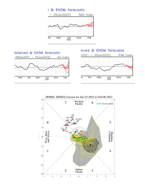
-
Winter 2021-22 Short/Medium Range Discussion
buckeye replied to Chicago Storm's topic in Lakes/Ohio Valley
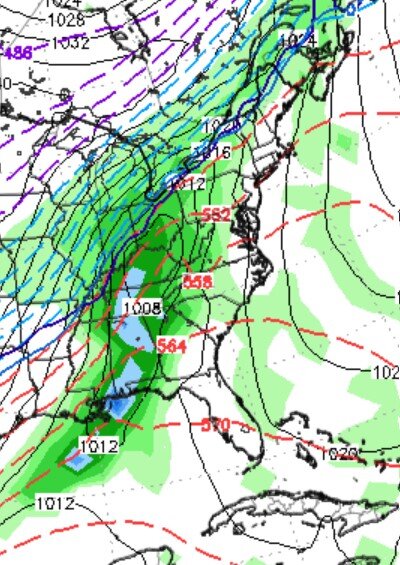
Epic blizzard for Pitt. 959mb, considering the Jan'78 blizz was 951mb over CLE.... pretty impressive...and unlikely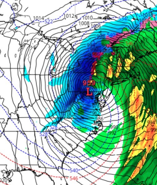
-
Looks like 3-5 was the right forecast for Columbus area. Can't really call it a disappointment since I don't think there were too many calls for more than that other then some of the goofy model outputs.
-
Probably closer to 3 then 4 here... now that I've been outside.
-
Looks like close to 4" here. Not bad for a hungry weenie. This one was a fun one to track.
-
freezing drizzle and sleet has turned to mod snow....radar looks great
-
I'm pretty sure we had some drizzle. Means things maybe a bit further nw. Good thing. Also I think some models showed mixing in the beginning.
-
Light pixie flurries in Westerville. And so it begins....
-
fire up the radar time....yes, Im still feeling optimistic for Columbus area


