

buckeye
-
Posts
8,771 -
Joined
Content Type
Profiles
Blogs
Forums
American Weather
Media Demo
Store
Gallery
Everything posted by buckeye
-
Tsun?
-
Not much. I think rgem is going to be an improvement....hard to tell on the crappy black and white maps.
-
I wouldn't take the hrrr seriously until later tomorrow. The extended hrrr is trash.
-
Then we should. No offense to anyone in the sub but this storm is the perfect example of why we should be separate. Chicago and MI posters are rooting for opposite trends as us. We all want to post info that bolsters the outcome we want. So it turns into a pissing match of "this model went south...that model went north...this model is trash...that model does the best"...etc. It's like being part of a sports forum and fans from two teams playing each other are posting in the same thread. Nothing good comes from it and it always turns into a pissing match.
-
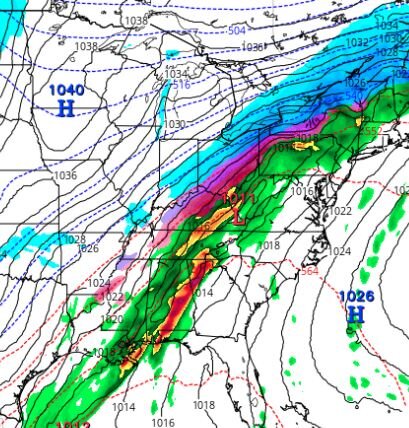
I flipped through the 500mb first and all features were slightly, but clearly southeast of 18z and yet the surface features were pretty much the same. I don't think the nam has the answer yet
-
Yea, I looked at tt and the mix line is a tad further north. Looked better on stormvista
-
can't wait until tomorrow when the radars are fired up and we start dissecting every hrrr run. You guys remember that one 2 years ago in January. Started off as rain and sleet and was suppose to changeover but it took hours longer than expected. The local meterologists caught all kinds of hell.
-
appears gfs not budging....if anything possible a tick southeast
-
So according to the rgem we have a 1040 high centered in southern MN, and a 1011 wave in southern WV. If someone asked me what that means for us, I'd say we'd be smoking cirrus.... and yet... we're getting an icestorm.
-
....well I guess we do need someone to cover the pessimism flank. I'm trying to hold on the the optism flank.
-
I still feel more like this will go in our favor once the changeover hits. The low on the nam travels just south of the Ohio river thru WV. That's not a bad track and the fact that it's a relatively weak low/strong wave, I don't see a ton of warm air being drawn north. Still have the high building in as well. What makes this tough is we are so close to the goods that real time, small, nuances could effect outcome big time. Stuff like convection in the south and intensity of precip. I also think how much of a break in precip between the two shots will have an effect on cold air progression. So to sum up....i have no f'ing clue other then to say I've seen these situation end up both good and bad.
-
still looking like either a big snow or a sleetfest. We probably won't have a better handle until this thing is on radar and moving towards us tomorrow afternoon.
-
yea, canadian looks like trash. Not just because it takes long to changeover, but it's pretty dry with the follow up wave. other than that, good trends. See what euro does then it's on to mesos and radar
-
worst sleet storm I recall was in Feb '94, we were sitting at 15 degrees all day with heavy sleet. I think we got 3-4" of it and then that evening it changed to freezing rain with thunderstorms. The next day people were ice skating on high street.
-
the nam making a significant shift southeast is telling. Last night it started looking like it was trending in a bad direction for us, but that turned around. At this stage, I think the trend will be our friend from here on out. Still gonna be a close one...but when aren't we riding the line?
-
Nam definitely looks better, less mix more snow. Fairly significant southeast shift.
-
Nam is pushing in the cold quicker. Looks like it's moving towards the gfs....so far
-
Yes, the warm will surge ahead of the front. Even Chicago may start out as some rain.
-
Looks like the set up is pretty well solidified other than bumps north and south. Boils down to the million dollar question...how quickly do we changeover? Riding the taint/snow line means the bookends on this one are amything from a foot of snow to a sleetfest. Looking back, I can think of as many times that we were pleasantly surprised with a quicker changeover and many times where the changeover took forever. No idea which way yet.
-
Noticed that as well. I always flip through the 500mb first and the shift southeast was much more evident then the surface map showed.
-
Looks like euro ticked southeast a bit. We're riding the taint/snow line as usual....that would be a good thing with the trends hopefully
-
I don't think it's a blip. I'm trying to keep mby biases out of my thinking but I really believe this continues ticking southeast as the models are starting to make the northern branch quicker and stronger with the high. We've seen this before. Unlike an organized storm coming out of the southern states where I'd be worried about a nw last minute shift, this is essentially a pushing arctic boundary with copius overrunning moisture and no wound up low to pull up a warm tongue or phase into something stronger.
-
March '08 that crushed you guys I thought about Dec 04 too. That was a rare one that came east at the last minute and had a strong high pushing behind it. But similar idea.
-
I'll pass
-
the gfs huge amounts are what happens when whoever gets the overrunning also gets the max of the storm that forms on the front. That's how we scored 22" in March'08. We got about half from the overrunning and then there was a several hour lull and then the storm came up and dumped the rest on us. So the gfs is totally plausible, the prize is bigger but the winners circle is smaller. Euro is a nice storm for a large part of the sub.


