kayman
-
Posts
782 -
Joined
-
Last visited
Content Type
Profiles
Blogs
Forums
American Weather
Media Demo
Store
Gallery
Everything posted by kayman
-
Severe Weather Statement National Weather Service Paducah KY 857 PM CDT Wed Apr 2 2025 INC051-147-163-173-KYC101-030245- /O.CON.KPAH.TO.W.0078.000000T0000Z-250403T0245Z/ Warrick IN-Vanderburgh IN-Spencer IN-Gibson IN-Henderson KY- 857 PM CDT Wed Apr 2 2025 ...A TORNADO WARNING REMAINS IN EFFECT UNTIL 945 PM CDT FOR WARRICK...VANDERBURGH...WEST CENTRAL SPENCER...SOUTHEASTERN GIBSON AND NORTHEASTERN HENDERSON COUNTIES... At 856 PM CDT, tornado producing storms were located along a line extending from near Kasson to Evansville to near Henderson, moving northeast at 75 mph. HAZARD...Damaging tornado. SOURCE...Radar confirmed tornado. IMPACT...Flying debris will be dangerous to those caught without shelter. Mobile homes will be damaged or destroyed. Damage to roofs, windows, and vehicles will occur. Tree damage is likely. These tornadic storms will be near... Newburgh, Melody Hill, Darmstadt, Chandler, Henderson, and Evansville around 900 PM CDT. Boonville around 905 PM CDT. Lynnville around 910 PM CDT. Folsomville around 915 PM CDT. Other locations impacted by these tornadic storms include Elberfeld and Tennyson. This includes the following highways... Interstate 69 in Indiana between Mile Markers 1 and 23. Interstate 64 in Indiana between Mile Markers 27 and 52. PRECAUTIONARY/PREPAREDNESS ACTIONS... To repeat, a tornado is on the ground. TAKE COVER NOW! Move to a basement or an interior room on the lowest floor of a sturdy building. Avoid windows. If you are outdoors, in a mobile home, or in a vehicle, move to the closest substantial shelter and protect yourself from flying debris. Tornadoes are extremely difficult to see and confirm at night. Do not wait to see or hear the tornado. TAKE COVER NOW! && LAT...LON 3802 8711 3790 8738 3782 8767 3783 8767 3795 8764 3802 8770 3805 8770 3820 8748 3821 8746 3821 8708 3820 8706 TIME...MOT...LOC 0156Z 238DEG 63KT 3806 8763 3799 8757 3788 8760 TORNADO...OBSERVED MAX HAIL SIZE...<.75 IN $$ DWS
-
Severe Weather Statement National Weather Service Paducah KY 906 PM CDT Wed Apr 2 2025 KYC033-055-143-030230- /O.CON.KPAH.TO.W.0075.000000T0000Z-250403T0230Z/ Crittenden KY-Caldwell KY-Lyon KY- 906 PM CDT Wed Apr 2 2025 ...A TORNADO WARNING REMAINS IN EFFECT UNTIL 930 PM CDT FOR SOUTH CENTRAL CRITTENDEN...NORTHWESTERN CALDWELL AND NORTH CENTRAL LYON COUNTIES... At 906 PM CDT, a confirmed tornado was located near Eddyville, moving northeast at 55 mph. HAZARD...Damaging tornado. SOURCE...Weather spotters confirmed tornado. IMPACT...Flying debris will be dangerous to those caught without shelter. Mobile homes will be damaged or destroyed. Damage to roofs, windows, and vehicles will occur. Tree damage is likely. This tornado will be near... Creswell and Farmersville around 910 PM CDT. Other locations impacted by this tornadic thunderstorm include Fredonia. This includes Interstate 69 in Kentucky between Mile Markers 71 and 73. PRECAUTIONARY/PREPAREDNESS ACTIONS... To repeat, a tornado is on the ground. TAKE COVER NOW! Move to a basement or an interior room on the lowest floor of a sturdy building. Avoid windows. If you are outdoors, in a mobile home, or in a vehicle, move to the closest substantial shelter and protect yourself from flying debris. && LAT...LON 3722 8820 3736 8799 3718 8782 3714 8791 3708 8809 TIME...MOT...LOC 0206Z 239DEG 49KT 3716 8804 TORNADO...OBSERVED MAX HAIL SIZE...<.75 IN $$ JGG
-
CC on the Indianapolis NWS with a debris signature headed towards Ball State University Severe Weather Statement National Weather Service Indianapolis IN 1002 PM EDT Wed Apr 2 2025 INC035-095-030215- /O.CON.KIND.TO.W.0026.000000T0000Z-250403T0215Z/ Madison IN-Delaware IN- 1002 PM EDT Wed Apr 2 2025 ...A TORNADO WARNING REMAINS IN EFFECT UNTIL 1015 PM EDT FOR NORTHERN MADISON AND DELAWARE COUNTIES... At 1002 PM EDT, a confirmed tornado was located 7 miles south of Matthews, or 8 miles northwest of Muncie, moving northeast at 70 mph. HAZARD...Damaging tornado. SOURCE...Radar confirmed tornado. IMPACT...Flying debris will be dangerous to those caught without shelter. Mobile homes will be damaged or destroyed. Damage to roofs, windows, and vehicles will occur. Tree damage is likely. Locations impacted include... Orestes, Eaton, Ball State University, Selma, Summitville, Gaston, Muncie, Daleville, Alexandria, Albany, Yorktown, Frankton, and Chesterfield. This includes Interstate 69 between mile markers 233 and 252. PRECAUTIONARY/PREPAREDNESS ACTIONS... To repeat, a tornado is on the ground. TAKE COVER NOW! Move to a basement or an interior room on the lowest floor of a sturdy building. Avoid windows. If you are outdoors, in a mobile home, or in a vehicle, move to the closest substantial shelter and protect yourself from flying debris. && LAT...LON 4009 8555 4025 8582 4038 8576 4038 8534 4030 8522 4020 8522 TIME...MOT...LOC 0202Z 236DEG 61KT 4028 8551 TORNADO...OBSERVED MAX HAIL SIZE...<.75 IN $$ Updike
-
I was talking about this bookend vortex aka commahead via the Indianapolis NWS radar & velocity that moved through I-465 beltway around Indianapolis on the Lake/Midwest regional forum.
-
I suppose the low-level wind shear and helicity made up for the lack of other ingredients for the severe threat that yielded this radar confirmed tornado in the Indianapolis metro area.
-
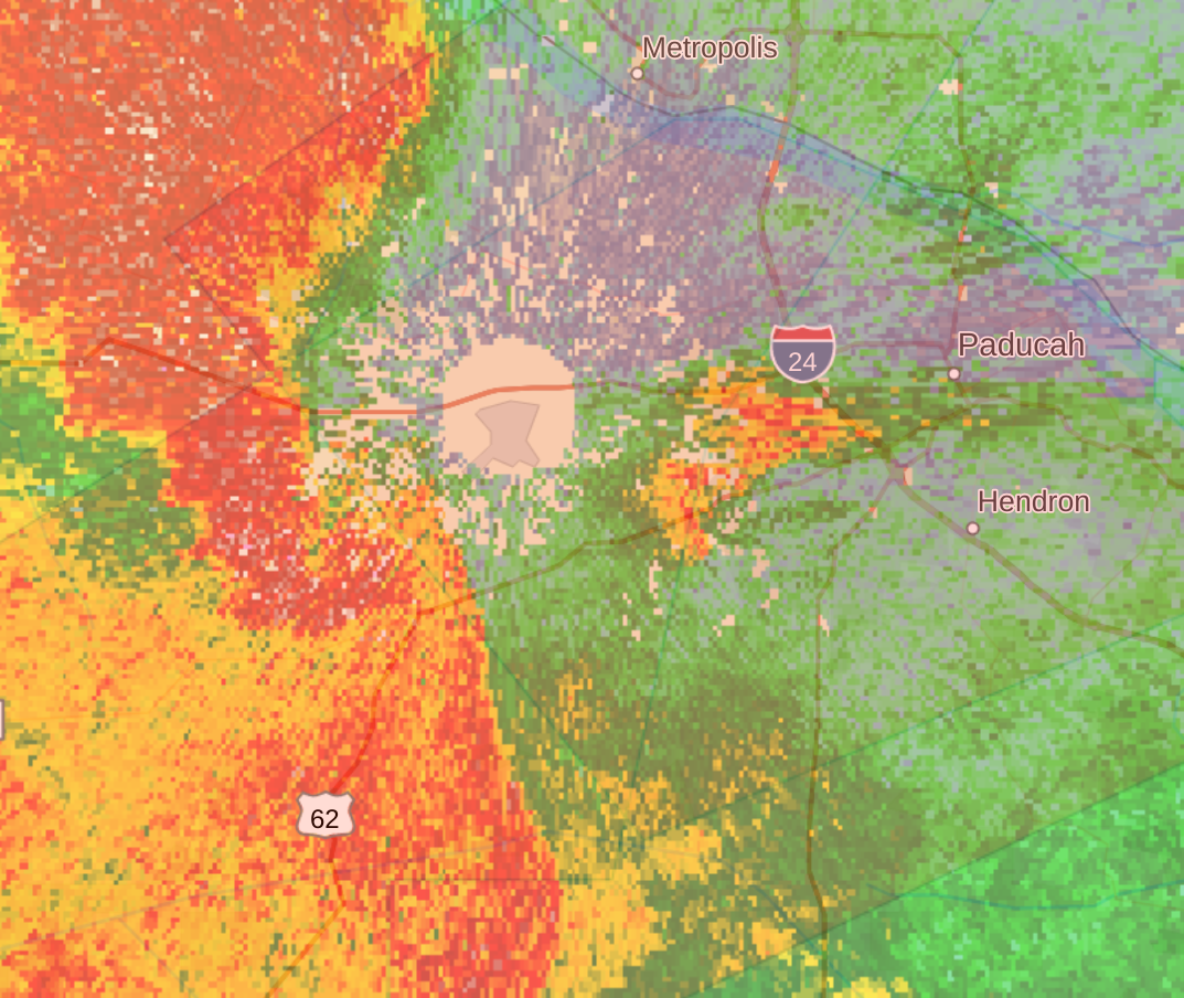
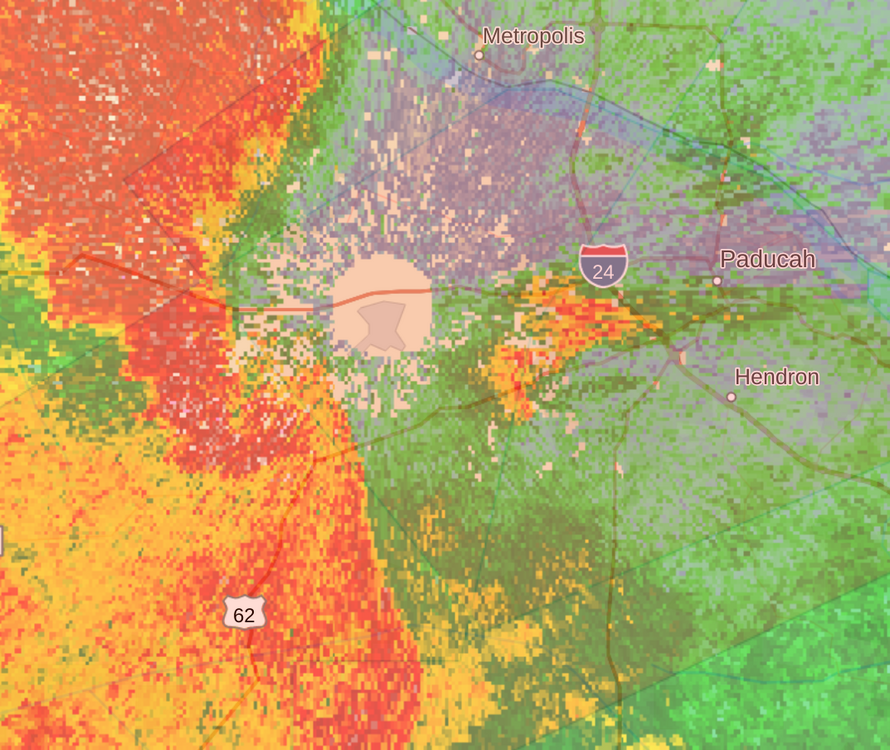
You're correct Severe Weather Statement National Weather Service Paducah KY 836 PM CDT Wed Apr 2 2025 ILC127-151-KYC145-030200- /O.CON.KPAH.TO.W.0073.000000T0000Z-250403T0200Z/ Massac IL-Pope IL-McCracken KY- 836 PM CDT Wed Apr 2 2025 ...A TORNADO WARNING REMAINS IN EFFECT UNTIL 900 PM CDT FOR SOUTHEASTERN MASSAC...SOUTHEASTERN POPE AND CENTRAL MCCRACKEN COUNTIES... At 835 PM CDT, a confirmed tornado was located over midtown Paducah near Park Avenue , moving east at 50 mph. HAZARD...Damaging tornado. SOURCE...Radar confirmed tornado. IMPACT...Flying debris will be dangerous to those caught without shelter. Mobile homes will be damaged or destroyed. Damage to roofs, windows, and vehicles will occur. Tree damage is likely. This tornado will be near... Paducah, Reidland, and Brookport around 840 PM CDT. This includes the following highways... Interstate 24 in Kentucky between Mile Markers 1 and 11. Interstate 24 in Illinois between Mile Markers 34 and 38. PRECAUTIONARY/PREPAREDNESS ACTIONS... To repeat, a tornado is on the ground. TAKE COVER NOW! Move to a basement or an interior room on the lowest floor of a sturdy building. Avoid windows. If you are outdoors, in a mobile home, or in a vehicle, move to the closest substantial shelter and protect yourself from flying debris. && LAT...LON 3732 8850 3729 8851 3726 8851 3722 8847 3721 8845 3716 8843 3707 8847 3707 8853 3708 8857 3707 8857 3703 8852 3698 8869 3713 8884 TIME...MOT...LOC 0135Z 247DEG 44KT 3710 8864 TORNADO...OBSERVED MAX HAIL SIZE...<.75 IN $$ JGG
-
A "bookend vortex" aka comma-head that spun a quick tornado that has been apparently confirmed on the ground by the Indianapolis NWS radar.
-
Yep Tornado Warning INC011-057-059-097-030145- /O.NEW.KIND.TO.W.0023.250403T0122Z-250403T0145Z/ BULLETIN - EAS ACTIVATION REQUESTED Tornado Warning National Weather Service Indianapolis IN 922 PM EDT Wed Apr 2 2025 The National Weather Service in Indianapolis has issued a * Tornado Warning for... Northwestern Hancock County in central Indiana... Northern Marion County in central Indiana... Southeastern Boone County in central Indiana... Hamilton County in central Indiana... * Until 945 PM EDT. * At 922 PM EDT, a tornado producing storm was located near Zionsville, or 9 miles northwest of Indianapolis, moving northeast at 65 mph. HAZARD...Damaging tornado. SOURCE...Radar confirmed tornado. IMPACT...Flying debris will be dangerous to those caught without shelter. Mobile homes will be damaged or destroyed. Damage to roofs, windows, and vehicles will occur. Tree damage is likely. * Locations impacted include... Geist Reservoir, Castleton, Carmel, Crows Nest, Noblesville, Spring Hill, Meridian Hills, Lawrence, Fishers, Wynnedale, Williams Creek, Rocky Ripple, Zionsville, Westfield, North Crows Nest, Morse Reservoir, Cicero, McCordsville, Broad Ripple, and Indianapolis. This includes Interstate 69 between mile markers 200 and 210. PRECAUTIONARY/PREPAREDNESS ACTIONS... To repeat, a tornado is on the ground. TAKE COVER NOW! Move to a basement or an interior room on the lowest floor of a sturdy building. Avoid windows. If you are outdoors, in a mobile home, or in a vehicle, move to the closest substantial shelter and protect yourself from flying debris. && LAT...LON 3983 8621 3996 8633 4017 8605 3989 8583 TIME...MOT...LOC 0122Z 243DEG 58KT 3988 8627 TORNADO...OBSERVED MAX HAIL SIZE...<.75 IN $$ Updike
-
I think that briefly has a TDS correlation coefficient on the Indianapolis NWS radar
-

-
That Crittenden County supercell is very interesting. The entire cell is rotating around itself from the NWS MEG radar velocity reflectivity. You can look at its motion and it is a tightly rotating mesocycle indeed.
-
-
This is thing is likely on the ground

-
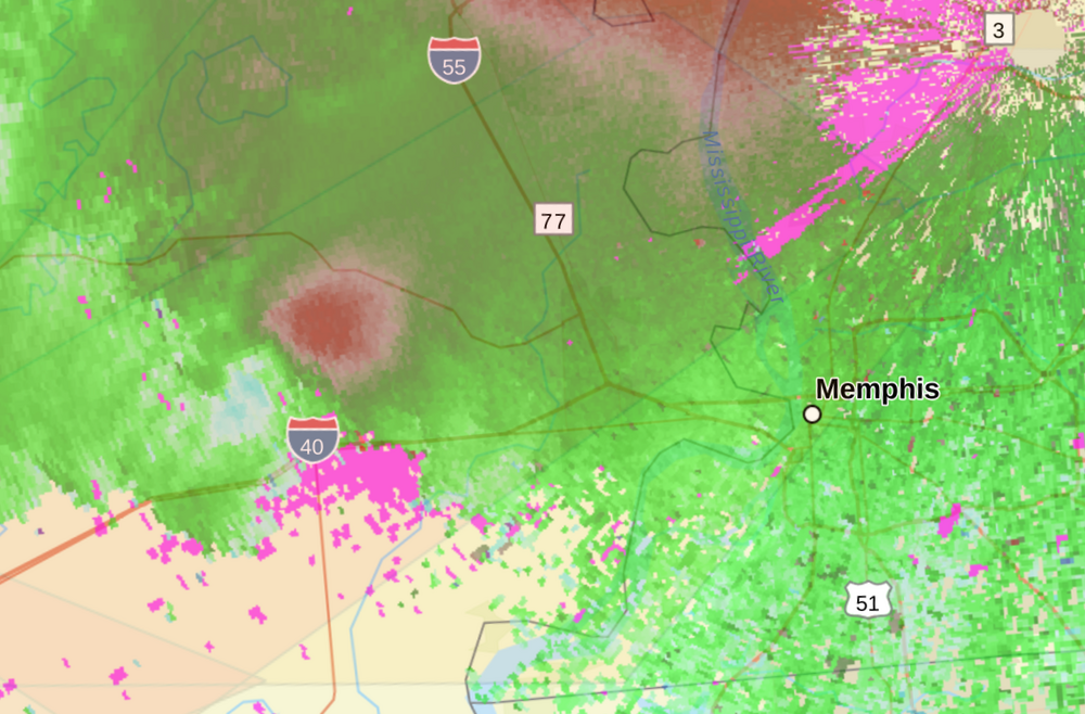
The Crittenden County, AR supercell is very ominous and likely on the ground. I'm looking at the NWS MEG radar velocity and it's extremely tight as it is headed towards West Memphis, AR.
-
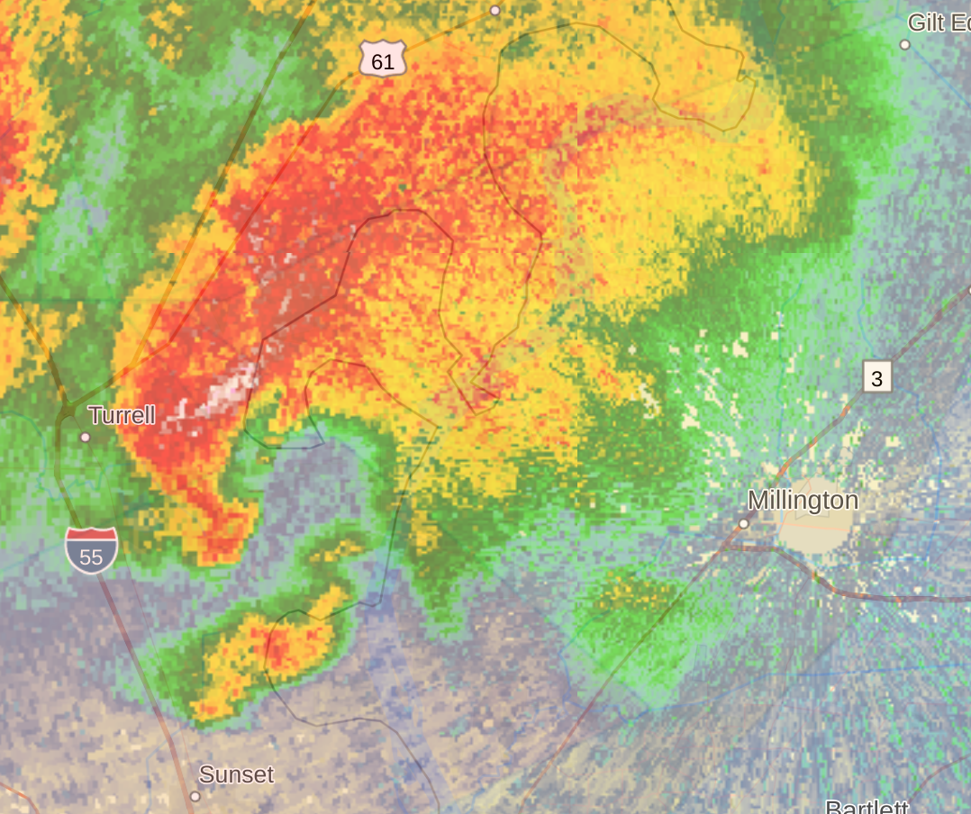
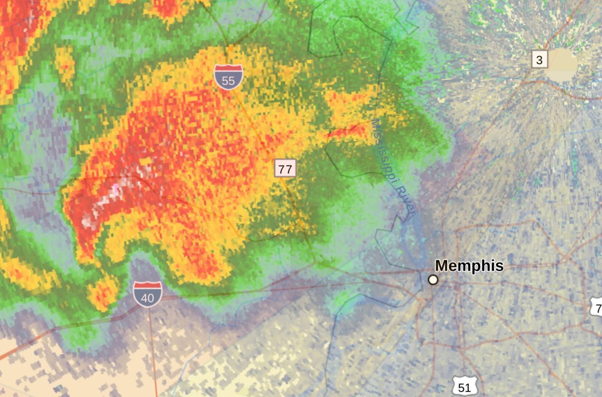
Yep, and this is basically a line of tornadic supercells. Anyone from Downtown Memphis and northward along the Mississippi River might need to be prepared for one of those supercells.
-
Severe Weather Statement National Weather Service Memphis TN 714 PM CDT Wed Apr 2 2025 ARC077-123-030045- /O.CON.KMEG.TO.W.0056.000000T0000Z-250403T0045Z/ Lee AR-St. Francis AR- 714 PM CDT Wed Apr 2 2025 ...A TORNADO WARNING REMAINS IN EFFECT UNTIL 745 PM CDT FOR NORTH CENTRAL LEE AND CENTRAL ST. FRANCIS COUNTIES... At 714 PM CDT, a confirmed tornado was located over Haynes, or 7 miles south of Forrest City, moving northeast at 45 mph. HAZARD...Damaging tornado and ping pong ball size hail. SOURCE...Weather spotters confirmed tornado. IMPACT...Flying debris will be dangerous to those caught without shelter. Mobile homes will be damaged or destroyed. Damage to roofs, windows, and vehicles will occur. Tree damage is likely. Locations impacted include... Whitmore, Madison, Gill, Bonair, Cottonwood Corner, Crow Creek, Caldwell, Forrest City, New Castle, Four Forks, Burnt Cane, Palestine, Haynes, Round Pond, Widener, Blackfish, Colt, Dodsons Corner, Heustess, and New Home. PRECAUTIONARY/PREPAREDNESS ACTIONS... To repeat, a tornado is on the ground. TAKE COVER NOW! Move to a storm shelter or an interior room on the lowest floor of a sturdy building. Avoid windows. If you are outdoors, in a mobile home, or in a vehicle, move to the closest substantial shelter and protect yourself from flying debris. && LAT...LON 3515 9080 3515 9076 3502 9045 3484 9084 3490 9095 3502 9090 TIME...MOT...LOC 0014Z 227DEG 40KT 3491 9079 TORNADO...OBSERVED MAX HAIL SIZE...1.50 IN $$ Schlessiger
-
In Northeastern AR, there is a bit of training by the those confirmed tornadic supercells. It's so many confirmed Tornado Warnings for that area that it is nearly impossible to discern the difference between 5 different warnings.
-
This one is headed for Crittenden County, AR on the west side of the Memphis metro area. Severe Weather Statement National Weather Service Memphis TN 657 PM CDT Wed Apr 2 2025 ARC035-077-123-030045- /O.CON.KMEG.TO.W.0056.000000T0000Z-250403T0045Z/ Lee AR-St. Francis AR-Crittenden AR- 657 PM CDT Wed Apr 2 2025 ...A TORNADO WARNING REMAINS IN EFFECT UNTIL 745 PM CDT FOR LEE...ST. FRANCIS AND SOUTHWESTERN CRITTENDEN COUNTIES... At 656 PM CDT, a confirmed tornado was located over Moro, or 12 miles west of Marianna, moving northeast at 45 mph. HAZARD...Damaging tornado and quarter size hail. SOURCE...Radar confirmed tornado. IMPACT...Flying debris will be dangerous to those caught without shelter. Mobile homes will be damaged or destroyed. Damage to roofs, windows, and vehicles will occur. Tree damage is likely. Locations impacted include... Garret Grove, Cody, Hughes, Cottonwood Corner, New Castle, Soudan, Round Pond, Beck, Brickeys, Ball Point, Tongin, Raggio, Gill, Hawkins, Mississippi River State Park, Penjur, Four Forks, Burnt Cane, Colt, and Dodsons Corner. PRECAUTIONARY/PREPAREDNESS ACTIONS... To repeat, a tornado is on the ground. TAKE COVER NOW! Move to a storm shelter or an interior room on the lowest floor of a sturdy building. Avoid windows. If you are outdoors, in a mobile home, or in a vehicle, move to the closest substantial shelter and protect yourself from flying debris. && LAT...LON 3487 9110 3515 9090 3515 9076 3494 9028 3485 9043 3489 9044 3489 9048 3486 9048 3483 9046 3465 9105 3473 9105 3474 9110 TIME...MOT...LOC 2356Z 227DEG 40KT 3475 9099 TORNADO...OBSERVED MAX HAIL SIZE...1.00 IN $$ Schlessiger
-
WMC-TV apparently has this live on air from an AR DOT traffic camera live on TV. Severe Weather Statement National Weather Service Memphis TN 654 PM CDT Wed Apr 2 2025 ARC037-123-030015- /O.CON.KMEG.TO.W.0052.000000T0000Z-250403T0015Z/ St. Francis AR-Cross AR- 654 PM CDT Wed Apr 2 2025 ...A TORNADO WARNING REMAINS IN EFFECT UNTIL 715 PM CDT FOR NORTH CENTRAL ST. FRANCIS AND CENTRAL CROSS COUNTIES... At 654 PM CDT, a confirmed tornado was located near Vanndale, or 8 miles northwest of Wynne, moving northeast at 60 mph. HAZARD...Damaging tornado and ping pong ball size hail. SOURCE...Weather spotters confirmed tornado. IMPACT...Flying debris will be dangerous to those caught without shelter. Mobile homes will be damaged or destroyed. Damage to roofs, windows, and vehicles will occur. Tree damage is likely. Locations impacted include... Wynne, Hawkins, Horton, Rosenbaum, River Front, Fitzgerald Crossing, Crow Creek, Caldwell, Wittsburg, Village Creek State Park, McElroy, Vanndale, Mersman, Colt, Fair Field, Cherry Valley, Ellis Chapel, Levesque, Hamlin, and Princedale. PRECAUTIONARY/PREPAREDNESS ACTIONS... To repeat, a tornado is on the ground. TAKE COVER NOW! Move to a storm shelter or an interior room on the lowest floor of a sturdy building. Avoid windows. If you are outdoors, in a mobile home, or in a vehicle, move to the closest substantial shelter and protect yourself from flying debris. && LAT...LON 3511 9098 3528 9092 3544 9095 3545 9074 3519 9057 3503 9089 TIME...MOT...LOC 2354Z 219DEG 51KT 3534 9085 TORNADO...OBSERVED MAX HAIL SIZE...1.50 IN $$ MJ
-
Severe Weather Statement National Weather Service Memphis TN 651 PM CDT Wed Apr 2 2025 ARC031-093-MOC069-155-030045- /O.CON.KMEG.TO.W.0055.000000T0000Z-250403T0045Z/ Craighead AR-Mississippi AR-Pemiscot MO-Dunklin MO- 651 PM CDT Wed Apr 2 2025 ...TORNADO EMERGENCY FOR MONETTE... ...A TORNADO WARNING REMAINS IN EFFECT UNTIL 745 PM CDT FOR NORTHEASTERN CRAIGHEAD...NORTHERN MISSISSIPPI...SOUTHWESTERN PEMISCOT AND SOUTHEASTERN DUNKLIN COUNTIES... At 650 PM CDT, a confirmed large and destructive tornado was located over Monette, moving northeast at 40 mph. TORNADO EMERGENCY for MONETTE. This is a PARTICULARLY DANGEROUS SITUATION. TAKE COVER NOW! HAZARD...Deadly tornado. SOURCE...Radar and spotter confirmed tornado. IMPACT...You are in a life-threatening situation. Flying debris may be deadly to those caught without shelter. Mobile homes will be destroyed. Considerable damage to homes, businesses, and vehicles is likely and complete destruction is possible. Locations impacted include... Jolliff Store, West Hermondale, Paulding, Delfore, Calumet, Dearman, New Survey, Vail, Denton, Gobler, Carmi, Covington, Whisp, Buckeye, Lester, Caruth, Deer Land, Arkmo, Temples Corner, and Caraway. PRECAUTIONARY/PREPAREDNESS ACTIONS... To repeat, a large, extremely dangerous, and potentially deadly tornado is on the ground. To protect your life, TAKE COVER NOW! Move to an interior room on the lowest floor of a sturdy building. Avoid windows. If in a mobile home, a vehicle or outdoors, move to the closest substantial shelter and protect yourself from flying debris. && LAT...LON 3622 8992 3593 8972 3574 9038 3590 9054 TIME...MOT...LOC 2350Z 234DEG 36KT 3589 9036 TORNADO...OBSERVED TORNADO DAMAGE THREAT...CATASTROPHIC MAX HAIL SIZE...1.00 IN $$ CAD
-
Brandon Copic Brandon Copic is following the Lake City, AR supercell It's a very large tornado.
-
Yeah, the language used by the NWS MEG (Memphis) office is scary af: Severe Weather Statement National Weather Service Memphis TN 640 PM CDT Wed Apr 2 2025 ARC031-093-111-MOC069-155-030045- /O.CON.KMEG.TO.W.0055.000000T0000Z-250403T0045Z/ Craighead AR-Poinsett AR-Mississippi AR-Pemiscot MO-Dunklin MO- 640 PM CDT Wed Apr 2 2025 ...TORNADO EMERGENCY FOR LAKE CITY AR... ...A TORNADO WARNING REMAINS IN EFFECT UNTIL 745 PM CDT FOR EASTERN CRAIGHEAD...NORTH CENTRAL POINSETT...NORTHERN MISSISSIPPI... SOUTHWESTERN PEMISCOT AND SOUTHEASTERN DUNKLIN COUNTIES... At 639 PM CDT, a confirmed large and destructive tornado was located over Lake City, moving northeast at 40 mph. TORNADO EMERGENCY for Lake City AR. This is a PARTICULARLY DANGEROUS SITUATION. TAKE COVER NOW! HAZARD...Deadly tornado. SOURCE...Radar confirmed tornado. IMPACT...You are in a life-threatening situation. Flying debris may be deadly to those caught without shelter. Mobile homes will be destroyed. Considerable damage to homes, businesses, and vehicles is likely and complete destruction is possible. Locations impacted include... Jolliff Store, West Hermondale, Paulding, Delfore, Calumet, Dearman, New Survey, Vail, Denton, Gobler, Carmi, Covington, Gum Point, Whisp, Buckeye, Lester, Deer Land, Arkmo, Temples Corner, and Caraway. PRECAUTIONARY/PREPAREDNESS ACTIONS... To repeat, a large, extremely dangerous, and potentially deadly tornado is on the ground. To protect your life, TAKE COVER NOW! Move to an interior room on the lowest floor of a sturdy building. Avoid windows. If in a mobile home, a vehicle or outdoors, move to the closest substantial shelter and protect yourself from flying debris. && LAT...LON 3622 8992 3593 8972 3565 9052 3583 9066 TIME...MOT...LOC 2339Z 233DEG 36KT 3580 9049 TORNADO...OBSERVED TORNADO DAMAGE THREAT...CATASTROPHIC MAX HAIL SIZE...1.00 IN $$ cad
-
If this brigade of tornadic supercells in Eastern Arkansas holds together West Tennessee is in some serious trouble in the next 2-3 hours. Mesoscale Discussion 363 < Previous MD Mesoscale Discussion 0363 NWS Storm Prediction Center Norman OK 0612 PM CDT Wed Apr 02 2025 Areas affected...Portions of the Mid-South Concerning...Tornado Watch 98... Valid 022312Z - 030045Z The severe weather threat for Tornado Watch 98 continues. SUMMARY...Numerous discrete supercells are intensifying in a very favorable environment for strong to intense tornadoes across the Mid-South. DISCUSSION...Numerous discrete right-moving supercells are intensifying across the open warm sector in the Mid-South as of 23Z. The NQA VWP depicts very large, clockwise-curved hodographs with ample streamwise vorticity for these storms (around 330 m2/s2 0-500m SRH). Given a moist/unstable boundary layer, ample low-level shear, and the well-established discrete supercells, several strong to intense tornadoes are possible through this corridor over the next couple hours. ..Weinman.. 04/02/2025 ...Please see www.spc.noaa.gov for graphic product... ATTN...WFO...PAH...MEG...JAN...LZK... LAT...LON 34009085 34259159 34699169 35159159 36289066 36499019 36468975 36348926 36078903 35798902 34179016 34009085 MOST PROBABLE PEAK TORNADO INTENSITY...155-190 MPH MOST PROBABLE PEAK WIND GUST...75-90 MPH MOST PROBABLE PEAK HAIL SIZE...2.00-3.50 IN
-
-