kayman
Members-
Posts
782 -
Joined
-
Last visited
-
Severe Weather Statement National Weather Service Paducah KY 857 PM CDT Wed Apr 2 2025 INC051-147-163-173-KYC101-030245- /O.CON.KPAH.TO.W.0078.000000T0000Z-250403T0245Z/ Warrick IN-Vanderburgh IN-Spencer IN-Gibson IN-Henderson KY- 857 PM CDT Wed Apr 2 2025 ...A TORNADO WARNING REMAINS IN EFFECT UNTIL 945 PM CDT FOR WARRICK...VANDERBURGH...WEST CENTRAL SPENCER...SOUTHEASTERN GIBSON AND NORTHEASTERN HENDERSON COUNTIES... At 856 PM CDT, tornado producing storms were located along a line extending from near Kasson to Evansville to near Henderson, moving northeast at 75 mph. HAZARD...Damaging tornado. SOURCE...Radar confirmed tornado. IMPACT...Flying debris will be dangerous to those caught without shelter. Mobile homes will be damaged or destroyed. Damage to roofs, windows, and vehicles will occur. Tree damage is likely. These tornadic storms will be near... Newburgh, Melody Hill, Darmstadt, Chandler, Henderson, and Evansville around 900 PM CDT. Boonville around 905 PM CDT. Lynnville around 910 PM CDT. Folsomville around 915 PM CDT. Other locations impacted by these tornadic storms include Elberfeld and Tennyson. This includes the following highways... Interstate 69 in Indiana between Mile Markers 1 and 23. Interstate 64 in Indiana between Mile Markers 27 and 52. PRECAUTIONARY/PREPAREDNESS ACTIONS... To repeat, a tornado is on the ground. TAKE COVER NOW! Move to a basement or an interior room on the lowest floor of a sturdy building. Avoid windows. If you are outdoors, in a mobile home, or in a vehicle, move to the closest substantial shelter and protect yourself from flying debris. Tornadoes are extremely difficult to see and confirm at night. Do not wait to see or hear the tornado. TAKE COVER NOW! && LAT...LON 3802 8711 3790 8738 3782 8767 3783 8767 3795 8764 3802 8770 3805 8770 3820 8748 3821 8746 3821 8708 3820 8706 TIME...MOT...LOC 0156Z 238DEG 63KT 3806 8763 3799 8757 3788 8760 TORNADO...OBSERVED MAX HAIL SIZE...<.75 IN $$ DWS
-
Severe Weather Statement National Weather Service Paducah KY 906 PM CDT Wed Apr 2 2025 KYC033-055-143-030230- /O.CON.KPAH.TO.W.0075.000000T0000Z-250403T0230Z/ Crittenden KY-Caldwell KY-Lyon KY- 906 PM CDT Wed Apr 2 2025 ...A TORNADO WARNING REMAINS IN EFFECT UNTIL 930 PM CDT FOR SOUTH CENTRAL CRITTENDEN...NORTHWESTERN CALDWELL AND NORTH CENTRAL LYON COUNTIES... At 906 PM CDT, a confirmed tornado was located near Eddyville, moving northeast at 55 mph. HAZARD...Damaging tornado. SOURCE...Weather spotters confirmed tornado. IMPACT...Flying debris will be dangerous to those caught without shelter. Mobile homes will be damaged or destroyed. Damage to roofs, windows, and vehicles will occur. Tree damage is likely. This tornado will be near... Creswell and Farmersville around 910 PM CDT. Other locations impacted by this tornadic thunderstorm include Fredonia. This includes Interstate 69 in Kentucky between Mile Markers 71 and 73. PRECAUTIONARY/PREPAREDNESS ACTIONS... To repeat, a tornado is on the ground. TAKE COVER NOW! Move to a basement or an interior room on the lowest floor of a sturdy building. Avoid windows. If you are outdoors, in a mobile home, or in a vehicle, move to the closest substantial shelter and protect yourself from flying debris. && LAT...LON 3722 8820 3736 8799 3718 8782 3714 8791 3708 8809 TIME...MOT...LOC 0206Z 239DEG 49KT 3716 8804 TORNADO...OBSERVED MAX HAIL SIZE...<.75 IN $$ JGG
-
CC on the Indianapolis NWS with a debris signature headed towards Ball State University Severe Weather Statement National Weather Service Indianapolis IN 1002 PM EDT Wed Apr 2 2025 INC035-095-030215- /O.CON.KIND.TO.W.0026.000000T0000Z-250403T0215Z/ Madison IN-Delaware IN- 1002 PM EDT Wed Apr 2 2025 ...A TORNADO WARNING REMAINS IN EFFECT UNTIL 1015 PM EDT FOR NORTHERN MADISON AND DELAWARE COUNTIES... At 1002 PM EDT, a confirmed tornado was located 7 miles south of Matthews, or 8 miles northwest of Muncie, moving northeast at 70 mph. HAZARD...Damaging tornado. SOURCE...Radar confirmed tornado. IMPACT...Flying debris will be dangerous to those caught without shelter. Mobile homes will be damaged or destroyed. Damage to roofs, windows, and vehicles will occur. Tree damage is likely. Locations impacted include... Orestes, Eaton, Ball State University, Selma, Summitville, Gaston, Muncie, Daleville, Alexandria, Albany, Yorktown, Frankton, and Chesterfield. This includes Interstate 69 between mile markers 233 and 252. PRECAUTIONARY/PREPAREDNESS ACTIONS... To repeat, a tornado is on the ground. TAKE COVER NOW! Move to a basement or an interior room on the lowest floor of a sturdy building. Avoid windows. If you are outdoors, in a mobile home, or in a vehicle, move to the closest substantial shelter and protect yourself from flying debris. && LAT...LON 4009 8555 4025 8582 4038 8576 4038 8534 4030 8522 4020 8522 TIME...MOT...LOC 0202Z 236DEG 61KT 4028 8551 TORNADO...OBSERVED MAX HAIL SIZE...<.75 IN $$ Updike
-
I was talking about this bookend vortex aka commahead via the Indianapolis NWS radar & velocity that moved through I-465 beltway around Indianapolis on the Lake/Midwest regional forum.
-
I suppose the low-level wind shear and helicity made up for the lack of other ingredients for the severe threat that yielded this radar confirmed tornado in the Indianapolis metro area.
-
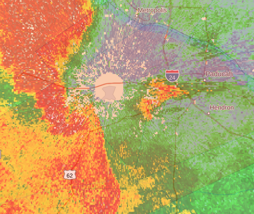
You're correct Severe Weather Statement National Weather Service Paducah KY 836 PM CDT Wed Apr 2 2025 ILC127-151-KYC145-030200- /O.CON.KPAH.TO.W.0073.000000T0000Z-250403T0200Z/ Massac IL-Pope IL-McCracken KY- 836 PM CDT Wed Apr 2 2025 ...A TORNADO WARNING REMAINS IN EFFECT UNTIL 900 PM CDT FOR SOUTHEASTERN MASSAC...SOUTHEASTERN POPE AND CENTRAL MCCRACKEN COUNTIES... At 835 PM CDT, a confirmed tornado was located over midtown Paducah near Park Avenue , moving east at 50 mph. HAZARD...Damaging tornado. SOURCE...Radar confirmed tornado. IMPACT...Flying debris will be dangerous to those caught without shelter. Mobile homes will be damaged or destroyed. Damage to roofs, windows, and vehicles will occur. Tree damage is likely. This tornado will be near... Paducah, Reidland, and Brookport around 840 PM CDT. This includes the following highways... Interstate 24 in Kentucky between Mile Markers 1 and 11. Interstate 24 in Illinois between Mile Markers 34 and 38. PRECAUTIONARY/PREPAREDNESS ACTIONS... To repeat, a tornado is on the ground. TAKE COVER NOW! Move to a basement or an interior room on the lowest floor of a sturdy building. Avoid windows. If you are outdoors, in a mobile home, or in a vehicle, move to the closest substantial shelter and protect yourself from flying debris. && LAT...LON 3732 8850 3729 8851 3726 8851 3722 8847 3721 8845 3716 8843 3707 8847 3707 8853 3708 8857 3707 8857 3703 8852 3698 8869 3713 8884 TIME...MOT...LOC 0135Z 247DEG 44KT 3710 8864 TORNADO...OBSERVED MAX HAIL SIZE...<.75 IN $$ JGG
-
A "bookend vortex" aka comma-head that spun a quick tornado that has been apparently confirmed on the ground by the Indianapolis NWS radar.
-
Yep Tornado Warning INC011-057-059-097-030145- /O.NEW.KIND.TO.W.0023.250403T0122Z-250403T0145Z/ BULLETIN - EAS ACTIVATION REQUESTED Tornado Warning National Weather Service Indianapolis IN 922 PM EDT Wed Apr 2 2025 The National Weather Service in Indianapolis has issued a * Tornado Warning for... Northwestern Hancock County in central Indiana... Northern Marion County in central Indiana... Southeastern Boone County in central Indiana... Hamilton County in central Indiana... * Until 945 PM EDT. * At 922 PM EDT, a tornado producing storm was located near Zionsville, or 9 miles northwest of Indianapolis, moving northeast at 65 mph. HAZARD...Damaging tornado. SOURCE...Radar confirmed tornado. IMPACT...Flying debris will be dangerous to those caught without shelter. Mobile homes will be damaged or destroyed. Damage to roofs, windows, and vehicles will occur. Tree damage is likely. * Locations impacted include... Geist Reservoir, Castleton, Carmel, Crows Nest, Noblesville, Spring Hill, Meridian Hills, Lawrence, Fishers, Wynnedale, Williams Creek, Rocky Ripple, Zionsville, Westfield, North Crows Nest, Morse Reservoir, Cicero, McCordsville, Broad Ripple, and Indianapolis. This includes Interstate 69 between mile markers 200 and 210. PRECAUTIONARY/PREPAREDNESS ACTIONS... To repeat, a tornado is on the ground. TAKE COVER NOW! Move to a basement or an interior room on the lowest floor of a sturdy building. Avoid windows. If you are outdoors, in a mobile home, or in a vehicle, move to the closest substantial shelter and protect yourself from flying debris. && LAT...LON 3983 8621 3996 8633 4017 8605 3989 8583 TIME...MOT...LOC 0122Z 243DEG 58KT 3988 8627 TORNADO...OBSERVED MAX HAIL SIZE...<.75 IN $$ Updike
-
I think that briefly has a TDS correlation coefficient on the Indianapolis NWS radar
-
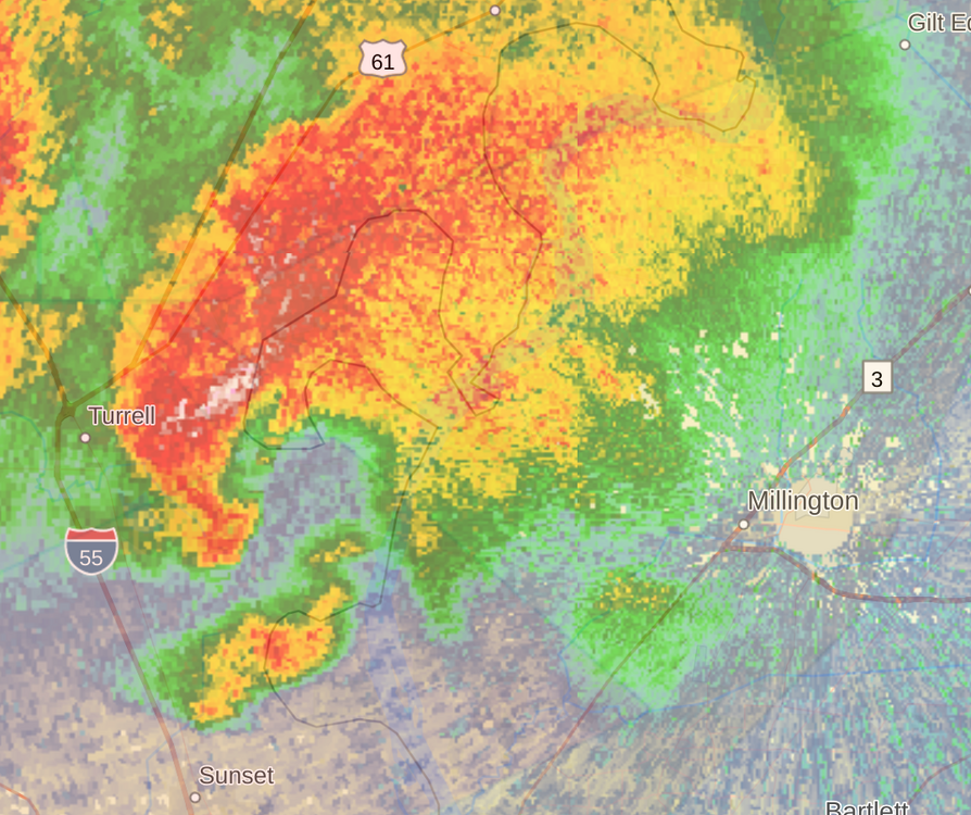
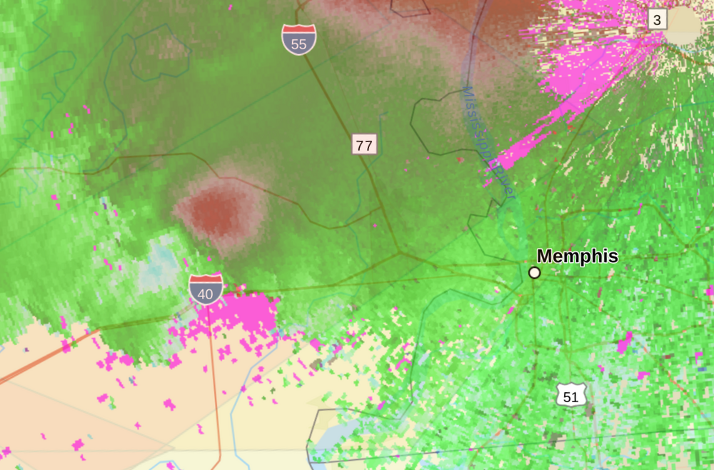
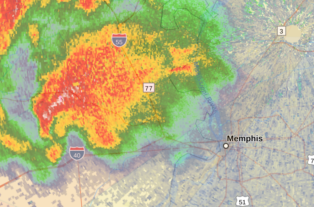
That Crittenden County supercell is very interesting. The entire cell is rotating around itself from the NWS MEG radar velocity reflectivity. You can look at its motion and it is a tightly rotating mesocycle indeed.
-
-
The Crittenden County, AR supercell is very ominous and likely on the ground. I'm looking at the NWS MEG radar velocity and it's extremely tight as it is headed towards West Memphis, AR.
-
Yep, and this is basically a line of tornadic supercells. Anyone from Downtown Memphis and northward along the Mississippi River might need to be prepared for one of those supercells.

