OKStorm
-
Posts
61 -
Joined
-
Last visited
Content Type
Profiles
Blogs
Forums
American Weather
Media Demo
Store
Gallery
Everything posted by OKStorm
-
Just as a side note we started with a cool spring in OK but set the yearly record with 147 tornadoes. Granted only one was a EF3 but it was a wild few weeks as it was happening. .
-
1345 and May 8th .
-
MO/KS/AR/OK 2019-2020 Winter Wonderland Discussion
OKStorm replied to JoMo's topic in Central/Western States
It is not like there is really warm air in the area, it is cold well south at this time. -
MO/KS/AR/OK 2019-2020 Winter Wonderland Discussion
OKStorm replied to JoMo's topic in Central/Western States
COPES can help you through this........ -
Read about the typhoon out near Guam. Said that a February typhoon had not hit there since 1953 which was a weak El Nino at the time. Looked at tornadoes in 53 and there were some very significant events. So we will see but maybe not so slow this year.
-
MO/KS/AR/OK 2019-2020 Winter Wonderland Discussion
OKStorm replied to JoMo's topic in Central/Western States
Just cancel this thread. It snowed in Malibu for crying out loud but Tulsa noooooo. -
MO/KS/AR/OK 2019-2020 Winter Wonderland Discussion
OKStorm replied to JoMo's topic in Central/Western States
I am so tired of the just too shallow cold around here. I am ready to move onto spring......... PREV DISCUSSION... /Issued 307 AM CST Sun Feb 17 2019/ DISCUSSION... Cold front currently moving through southeast Oklahoma into far northwest Arkansas early this morning. Areas of freezing drizzle will start to tapper off over the next couple hours, but still some slick spots on area roads, especially northwest of Tulsa. Skies are expected to clear from northwest to southeast this morning with mostly sunny skies this afternoon. Cold conditions will continue tonight into Monday morning as surface high pressure builds into the region. Complicated forecast expected on Tuesday, with multiple precip types possible, as upper level storm system moves into the four corners region. Areas of rain/ freezing rain/sleet are expected to spread north Tuesday morning given strong lift in association with right rear quad of upper jet. Temperatures will likely hold or fall to around freezing as precip develops through the day. Best chance for rain/freezing rain to transition to snow will likely be in areas north and west of Tulsa, however point soundings indicate saturation may not occur in favored dendritic growth zone. Any winter weather threat will end Tuesday night as upper jet streak lifts northeast. Still some differences concerning evolution of upper wave moving out the Baja region Wednesday into Thursday. GFS is more aggressive with wave, with another round of overrunning precip during the day Thursday. ECMWF keeps heavier rain well east of the area during this time, with significant warmup into Friday. Better rain chances are expected by Saturday as main upper low approaches. Given uncertainties in the exact track, will continue with chance pops through the remainder of the extended periods. -
MO/KS/AR/OK 2019-2020 Winter Wonderland Discussion
OKStorm replied to JoMo's topic in Central/Western States
Tulsa still going with mostly rain event for Tulsa metro. -
MO/KS/AR/OK 2019-2020 Winter Wonderland Discussion
OKStorm replied to JoMo's topic in Central/Western States
Good Morning Oklahoma today is pick and choose day
-
MO/KS/AR/OK 2019-2020 Winter Wonderland Discussion
OKStorm replied to JoMo's topic in Central/Western States
We would but we never get winter in OK anymore only only temps going between 15-20 and 75-80 all in a couple of days. -
High Risk May 4th I am going with 1301 for the year maybe with the end of the drought in OK things will get going again.
-
MO/KS/AR/OK 2019-2020 Winter Wonderland Discussion
OKStorm replied to JoMo's topic in Central/Western States
-
MO/KS/AR/OK 2019-2020 Winter Wonderland Discussion
OKStorm replied to JoMo's topic in Central/Western States
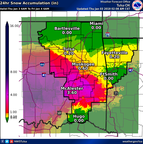
Does not appear so TSA calling for less than one inch in Tulsa at this time. Going for the rain over snow or ice. -
MO/KS/AR/OK 2019-2020 Winter Wonderland Discussion
OKStorm replied to JoMo's topic in Central/Western States
Rain moved thru Tulsa to the west in Creek Co bridges iced up very slick. Precipitation ended in west Tulsa for now showing 30 on the dash. -
MO/KS/AR/OK 2019-2020 Winter Wonderland Discussion
OKStorm replied to JoMo's topic in Central/Western States
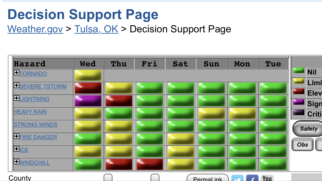
TSA not biting on snow for Tulsa Metro. Area Forecast Discussion National Weather Service Tulsa OK 407 PM CST Wed Jan 2 2019 .DISCUSSION... Complicated forecast this afternoon with ongoing areas of light freezing rain or freezing drizzle in parts of eastern OK and northwest AR that prompted a Winter Weather Advisory earlier today. Surface temperatures have gone virtually nowhere as warm conveyor precip continues to spread north up to near I-44 with a sharp cutoff on the northern edge. Temps are and will likely remain below freezing from about McAlester to Eureka Springs with slight moderation possible later tonight. Although short-wave ridging aloft will be over the are tonight, a near saturated layer will persist up through around 850mb per high res model soundings, thus while threat of measurable rainfall will eventually shift east, some patchy areas of freezing drizzle cannot be discounted. Thus have extended the Advisory into Thursday morning, as some slick overpasses have been reported. Potent upper low currently centered west of ELP will continue to move east Thursday, with a track somewhere in the vicinity of the Red River. Precip will begin to increase Thursday morning into the afternoon as the low moves east. Freezing remain potential during the morning will persist, and concern is that temperatures will not moderate much at all in the vicinity of heaviest precip band which is currently expected to set up close to the I-40 corridor. If temps remain cold enough a band of significant ice accumulation may set up and this will need to be watched closely. By afternoon most if not all locations should finally warm above freezing but again this is no guarantee where heaviest precip falls. For now will handle the potential with extension of existing Advisory. Areas in closer proximity to the upper low track will eventually see enough cooling through deeper layer to result in a chance to snow, with some potential for accumulations mainly across southeast OK in elevated terrain. -
MO/KS/AR/OK 2019-2020 Winter Wonderland Discussion
OKStorm replied to JoMo's topic in Central/Western States
Just plain ugly stats not to mention it snowed in Houston, New Orleans and now Fla today. Cancel winter now and get onto spring storms........ -
MO/KS/AR/OK 2019-2020 Winter Wonderland Discussion
OKStorm replied to JoMo's topic in Central/Western States
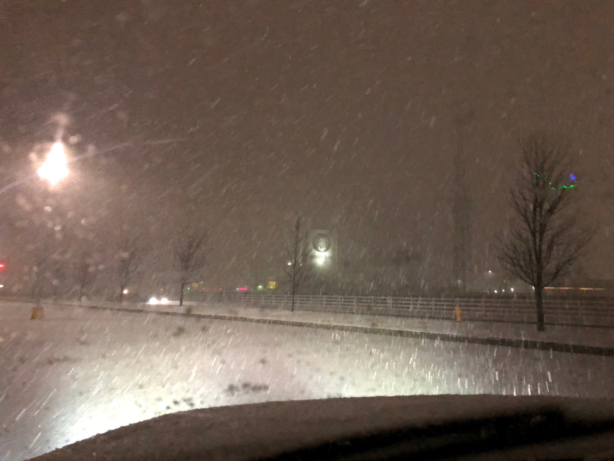
Had a nice burst of snow in Owasso last night about 2330 hours as the rain finally changed to all snow.