

Radtechwxman
-
Posts
2,324 -
Joined
-
Last visited
Content Type
Profiles
Blogs
Forums
American Weather
Media Demo
Store
Gallery
Everything posted by Radtechwxman
-

February 4th-7th Winter Storm Potential
Radtechwxman replied to Thundersnow12's topic in Lakes/Ohio Valley
This shall be an interesting few days of model battles. Lol. GFS certainly took a drastic shift. Nam attempted to but not as drastic and a much narrower band of snow. GFS was more spread the wealth. Lets see what King Euro shows -
February 4th-7th Winter Storm Potential
Radtechwxman replied to Thundersnow12's topic in Lakes/Ohio Valley
I mean yeah it can change but trends definitely not going in the right direction as of now -
February 4th-7th Winter Storm Potential
Radtechwxman replied to Thundersnow12's topic in Lakes/Ohio Valley
Another winter storm DOA. Is it tornado season yet? This has been the lamest winter for a good wrapped up winter storm -
February 4th-7th Winter Storm Potential
Radtechwxman replied to Thundersnow12's topic in Lakes/Ohio Valley
Pretty much the story of winter 2019-2020. Seems like the trend this winter is to look good in the long range then slowly fall apart as we get closer. Hoping we can get at least one decent wave out of this -
January 22nd-25th Winter Storm Potential
Radtechwxman replied to Thundersnow12's topic in Lakes/Ohio Valley
Man Rockford is in the sweet spot tonight in a training heavy band -
January 22nd-25th Winter Storm Potential
Radtechwxman replied to Thundersnow12's topic in Lakes/Ohio Valley
Well the last hurrah of this system sure went to crap. For such a pretty system on water vapor, it definitely isn't living up to how it looks. Lol. Lack of cold air ftw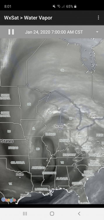
-
January 22nd-25th Winter Storm Potential
Radtechwxman replied to Thundersnow12's topic in Lakes/Ohio Valley
None of the models this morning are initializing well this morning with current low strength and placement. Most of them have a very broad 1012mb low over central IL and as of 1331z there's a 1009mb low just west of STL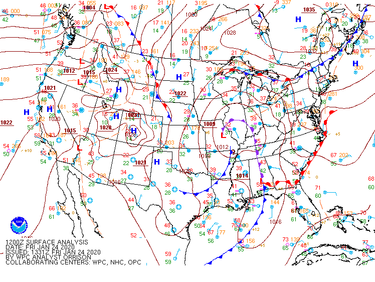
-
January 22nd-25th Winter Storm Potential
Radtechwxman replied to Thundersnow12's topic in Lakes/Ohio Valley
Ready to punt this sloppy mess of a storm. What happened to real winter storms? Seems like this last part is pushing more and more ne on model runs -
January 22nd-25th Winter Storm Potential
Radtechwxman replied to Thundersnow12's topic in Lakes/Ohio Valley
Finally ripping snow here. Nice fat flakes. But doesn't look like this will last super long tonight -
January 22nd-25th Winter Storm Potential
Radtechwxman replied to Thundersnow12's topic in Lakes/Ohio Valley
Same thing here. Pretty uneventful so far. Feel like Fri night into Sat will be best here -
January 22nd-25th Winter Storm Potential
Radtechwxman replied to Thundersnow12's topic in Lakes/Ohio Valley
I'm just surprised snowflakes are so tiny. I think my marginal temp now isn't helping. Snow barely accumulating -
January 22nd-25th Winter Storm Potential
Radtechwxman replied to Thundersnow12's topic in Lakes/Ohio Valley
Snow returns seem to be drying out in Peoria area. Seems like that band is struggling to lift north as well. Flakes are like pixie dust so far -
January 22nd-25th Winter Storm Potential
Radtechwxman replied to Thundersnow12's topic in Lakes/Ohio Valley
On temperatures? I'm thinking it's advancing the rain snow line west too quickly -
January 22nd-25th Winter Storm Potential
Radtechwxman replied to Thundersnow12's topic in Lakes/Ohio Valley
My thoughts exactly. And being near rain-snow line is a good sweet spot if you stay on snow side. Lol -
January 22nd-25th Winter Storm Potential
Radtechwxman replied to Thundersnow12's topic in Lakes/Ohio Valley
I know you're close to where I am. What do you think of hrrr bringing the rain snow line as west as the IL River? I think it could come close but sure as west as hrrr/rap show it -
January 22nd-25th Winter Storm Potential
Radtechwxman replied to Thundersnow12's topic in Lakes/Ohio Valley
Utter trash model. Literally shows rain here from tomorrow afternoon through the rest of the event. Makes no sense. I do believe there will be rain at times but there will definitely be snow at night -
January 22nd-25th Winter Storm Potential
Radtechwxman replied to Thundersnow12's topic in Lakes/Ohio Valley
Just nam is showing this current wave being more robust than it currently is so has me wondering if it is right on a more robust 2nd wave than other models -
January 22nd-25th Winter Storm Potential
Radtechwxman replied to Thundersnow12's topic in Lakes/Ohio Valley
0z hrrr torchy like gfs. Has rain wrapping around low all night Fri. I just don't buy that. There should be some CAA wrapping on backside of low. This first wave is definitely looking pretty paltry on radar. Wondering if precip by Gulf is disrupting moisture feed. Also looked like that first disturbance lifted more west than anticipated -
January 22nd-25th Winter Storm Potential
Radtechwxman replied to Thundersnow12's topic in Lakes/Ohio Valley
Totally agree with this. With an already high water content snow with low ratios marginal daytime temps will definitely favor more slush over accumulations and white rain like you said. I think best shot here will be overnight Thurs into Fri when wind direction shifts more northerly as upper low pulls east -
January 22nd-25th Winter Storm Potential
Radtechwxman replied to Thundersnow12's topic in Lakes/Ohio Valley
GFS continues to be a torch with most snow confined to Great Lakes. Either it's going to hit a home run being the only model sniffing out warmer temps or going to look really stupid next to the rest of guidance. I do believe there will be transitions between rain and snow especially preceding the main upper low closing off. However I think once that upper low deepens and closes off that things will certainly be more snowier than gfs is depicting -
January 22nd-25th Winter Storm Potential
Radtechwxman replied to Thundersnow12's topic in Lakes/Ohio Valley
Definitely very marginal temps for any accumulation. However with a relatively strong closed low and the fact it will be strengthening as it passes over us, makes me think dynamics could compensate for lack of colder air. I remember this clipper a few years ago came through with very marginal temps but it was very compact and wound up. We ended up dynamically cooling to around 32-31 and efficiently accumulated snow with moderate to sometimes heavy rates. I know this isn't a clipper but made me think of how wrapped up this system is aloft -
January 22nd-25th Winter Storm Potential
Radtechwxman replied to Thundersnow12's topic in Lakes/Ohio Valley
Pretty similar. Semi on board with nam with colder and snowier. Gfs has a lot more rain and snow slop. To me the pattern would support a more gfs like solution but we shall see -
January 22nd-25th Winter Storm Potential
Radtechwxman replied to Thundersnow12's topic in Lakes/Ohio Valley
Yea I'm loving the nam. Keeps the profiles colder. Would like to see support from other models though. GFS and Euro are warmer with more mixed precipitation versus snow -
I'm curious how accurate this precip depiction algorithm is. Currently says 33 here but airport reporting freezing rain. Surface freezing line definitely making good progress north now
-
This precip is moving pretty rapidly. Been all snow here so far. I'm honestly not sure we will see much of a period of sleet or freezing rain. Pretty substantial dry slot advancing north and east. Snow ripping pretty good here now though. Probably will be in the 2-3in range


