

Radtechwxman
-
Posts
2,324 -
Joined
-
Last visited
Content Type
Profiles
Blogs
Forums
American Weather
Media Demo
Store
Gallery
Everything posted by Radtechwxman
-

March 26-28 Severe Threat
Radtechwxman replied to Tim from Springfield (IL)'s topic in Lakes/Ohio Valley
I think our fate was sealed after that late wave of morning to afternoon storms. Then that feed of showers and clouds continued all day, at least in IL. Moisture quality seemed to be less than what was forecasted. Just goes to show you how a few variables being off can totally change an otherwise potent tornado setup. That's Jonesboro storm was insane. That tornado looked just like Tuscaloosa. Curious to see what the environment was near that storm -
March 26-28 Severe Threat
Radtechwxman replied to Tim from Springfield (IL)'s topic in Lakes/Ohio Valley
I'm definitely getting the bust vibe from this from a tornado outbreak standpoint. Too much shear and not enough cape. I think IL could see some severe storms later but how significant I'm unsure -
March 26-28 Severe Threat
Radtechwxman replied to Tim from Springfield (IL)'s topic in Lakes/Ohio Valley
Yea these dew points are drastically lower than models depicted. I'm surprised. There was a good reservoir of mid to upper 60 dews in the lower mid Mississippi Valley last night. Really thought those would advect north quickly. I think the EML ended up being less robust and maybe some mixing near dry slot. IL has been in training showers and clouds all day. Dry slot is finally progressing east but not sure we will have enough time to recover much. Definitely wasn't expecting all this crapvection to persist so long -
March 26-28 Severe Threat
Radtechwxman replied to Tim from Springfield (IL)'s topic in Lakes/Ohio Valley
I think hrrr may be overconvecting imo. It was way off on extent of elevated storms last night. This complex is MO is definitely the fly in the ointment. If more storms don't blow up besides that, I think this could still be a big day. That remains to be seen -
March 26-28 Severe Threat
Radtechwxman replied to Tim from Springfield (IL)'s topic in Lakes/Ohio Valley
A prefrontal trough would certainly increase the tornado potential for this. Prevent a more linear storm mode near pacific front -
March 26-28 Severe Threat
Radtechwxman replied to Tim from Springfield (IL)'s topic in Lakes/Ohio Valley
Don't think there will be any issue seeing mid to upper 60 dews in moderate risk area. 3km nam definitely highlights a potential fly in the ointment with convection persisting into the afternoon instead of clearing mid to late morning like HRRR -
March 26-28 Severe Threat
Radtechwxman replied to Tim from Springfield (IL)'s topic in Lakes/Ohio Valley
Current dew points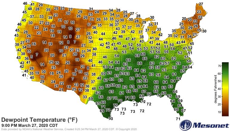
-
March 26-28 Severe Threat
Radtechwxman replied to Tim from Springfield (IL)'s topic in Lakes/Ohio Valley
3km nam at other end of spectrum of hrrr. Multiple rounds of convection lasting into the afternoon. Would definitely temper the threat and likely shift it west and south -
March 26-28 Severe Threat
Radtechwxman replied to Tim from Springfield (IL)'s topic in Lakes/Ohio Valley
0z hrrr is verbatim high risk worthy. Those helicity tracks are mind boggling. I think cape/dews may be overdone a bit but regardless still looks to be a big day -
March 26-28 Severe Threat
Radtechwxman replied to Tim from Springfield (IL)'s topic in Lakes/Ohio Valley
Yea that was my concern. Directional shear not as good west so storms could struggle till they got more east but would they get too messy before getting to the better environment? Plus MO is just not chasing friendly so definitely prefer the threat further east. I do agree HRRR is probably too fast but NAM seems too slow. 0z HRRR running now. Let the fun begin -
March 26-28 Severe Threat
Radtechwxman replied to Tim from Springfield (IL)'s topic in Lakes/Ohio Valley
Definitely noticing that on the nams. My question is if that was right, would they start producing right away or further east? Winds are more backed east. Curious to see if hrrr caves towards that or holds firm -
March 26-28 Severe Threat
Radtechwxman replied to Tim from Springfield (IL)'s topic in Lakes/Ohio Valley
No need for your sarcasm. Just saying given the parameters I am seeing and the potential I don't think they're hitting the tornado potential as hard as they should. Yes there is bust potential as with any setup but I can name more positive than negative aspects with this. These storms will be in some populated areas, more so than any setup so far this year and I just hope people understand the potential of this to produce strong to potentially violent tornadoes. I'm not saying I'm better than any NWS forecaster but I do think they been quite conservative and that concerns me. -
March 26-28 Severe Threat
Radtechwxman replied to Tim from Springfield (IL)'s topic in Lakes/Ohio Valley
It's seriously embarrassing what ILX does. They always refer to SPC discussion. Like do your own analysis. DVN was uncharacteristically conservative. LOT great as always. Not sure what the other offices aren't seeing -
March 26-28 Severe Threat
Radtechwxman replied to Tim from Springfield (IL)'s topic in Lakes/Ohio Valley
Yea not sure I buy this thing slowly that much with initiation that west. Pretty drastic shift. Hrrr makes more sense with timing. I could see a somewhat slower trend and possibly more west of hrrr but nothing like the nam's -
March 26-28 Severe Threat
Radtechwxman replied to Tim from Springfield (IL)'s topic in Lakes/Ohio Valley
Lol. Built the hype. Now time for it to get crushed. Yea 12z euro definitely was weaker esp with sfc wind speeds. Killed the hodo in the low levels. But since that isn't a high resolution model probably would put more faith in shorter term hi res models -
March 26-28 Severe Threat
Radtechwxman replied to Tim from Springfield (IL)'s topic in Lakes/Ohio Valley
DVN is being majorly conservative: THE LIKELY SPEED OF THE LINE (POTENTIALLY 45-50 MPH) MEANS DAMAGING WINDS AND LARGE HAIL ARE EXPECTED. IF LOW LEVEL WIND FIELDS BECOME FAVORABLE THEN ISOLATED TORNADOES CANNOT BE RULED OUT. -
March 26-28 Severe Threat
Radtechwxman replied to Tim from Springfield (IL)'s topic in Lakes/Ohio Valley
Well I referenced it was it that sweet spot to se of sfc low so kind of inferring that. Lol. But pretty sure I read somewhere it interacted with an ofb as well -
March 26-28 Severe Threat
Radtechwxman replied to Tim from Springfield (IL)'s topic in Lakes/Ohio Valley
I was thinking that to. That day overall had veered sfc flow. I think that storm was a mesoscale accident. Hit an ofb from previous storms. Wf was well north of it. It was also in that sweet spot just se of a rapidly deepening sfc low -
I don't blame Thompson. That was a terrible outlook by Broyles. This is how it should have looked last night. Mentioned potential upgrade to in further outlooks
-
Yea he is being very conservative which is unlike him. Tornadoes were definitely worth mentioning. Slight risk areas should be bigger to especially up north
-
Mid-week potential of something somewhere
Radtechwxman replied to Chicago Storm's topic in Lakes/Ohio Valley
It's been snowing here off and on all day. Still no accumulation. Lol. This band pivoting over me is probably dumping at .000000001 in/hr -
Mid-week potential of something somewhere
Radtechwxman replied to Chicago Storm's topic in Lakes/Ohio Valley
Slower/later phase definitely favoring you Michigan folk -
Mid-week potential of something somewhere
Radtechwxman replied to Chicago Storm's topic in Lakes/Ohio Valley
Will probably be congratulating Florida by tomorrow morning -
Mid-week potential of something somewhere
Radtechwxman replied to Chicago Storm's topic in Lakes/Ohio Valley
Wow and the trend continues. Unbelievable. I really thought the se trend would stop. Barely get 1-2in now. Like I said days ago when I was suppose to get rain....punt -
Mid-week potential of something somewhere
Radtechwxman replied to Chicago Storm's topic in Lakes/Ohio Valley
Yes I was expecting rain days ago. Yes I'm in a watch now. But I'm hardcore skeptical. Lol. Esp with models still shifting around. Going with the good ol' wait and see what happens. My current forecast is 0-6in. Lol. Would be nice to actually have a snowstorm without a trash antecedent air mass. Lol. But hey this is good for winter 2019-2020. I think our biggest snow this yr here was like 4.5in. So potential to break that if everything pans out. We shall see. Curious if 0z runs continue the downfall or maybe trend back somewhat


