Radtechwxman
-
Posts
2,324 -
Joined
-
Last visited
Content Type
Profiles
Blogs
Forums
American Weather
Media Demo
Store
Gallery
Everything posted by Radtechwxman
-

Historic Lake Effect Event?! 11/17-11/21
Radtechwxman replied to BuffaloWeather's topic in Upstate New York/Pennsylvania
That's all they said for your location?? -
Historic Lake Effect Event?! 11/17-11/21
Radtechwxman replied to BuffaloWeather's topic in Upstate New York/Pennsylvania
Did you mean Hamburg? Because Buffalo is currently north of the band -
Historic Lake Effect Event?! 11/17-11/21
Radtechwxman replied to BuffaloWeather's topic in Upstate New York/Pennsylvania
This is mind boggling. Metro Buffalo just getting missed -
Historic Lake Effect Event?! 11/17-11/21
Radtechwxman replied to BuffaloWeather's topic in Upstate New York/Pennsylvania
This band really flew south quick tonight. I know South Buffalo was always favored for bigger totals though. Curious when band will venture back north. Northern portions of Buffalo may be snow free a while now. -
I understood what he was trying to say and still stand behind my explanation. I think the NHC knows what they're doing
-
We have failed Ian and this thread
-
Unfortunately once over land recon can't fly into Ian so they use satellite estimates and models that estimate weakening so is it perfect? No. Could Ian be weaker than this? Yes. But is it still a powerful and dangerous hurricane? Definitely. That nw eyewall is still pounding many cities with high end winds and extreme flooding rain.
-
You are rarely ever going to see those measurements on land for many reasons. Most weather instruments fail before being able to reach those speeds, there often isn't weather stations in the areas that get the highest winds, and friction of land slows wind so always will be highest over water. NHC wasn't wrong with their intensity, you just won't see many reports of those high end winds but the damage will reflect it. There wasn't a ton with Michael up in that cat 4-5 range but look what it did....
-
He about got taken out by a big tree branch. Lol
-
Definitely. Impacts are the same whether it was cat 4 or 5. Absolutely devastating
-
150mph 940mb now. Don't think we saw a cat 5 landfall but it was real close
-
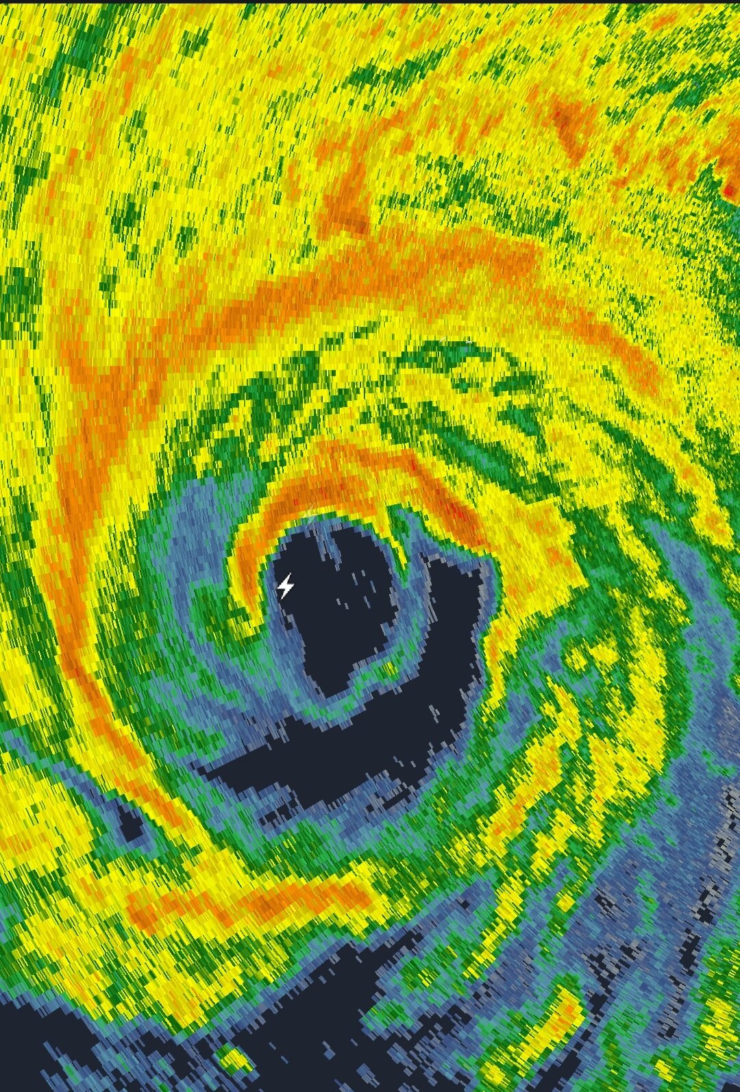
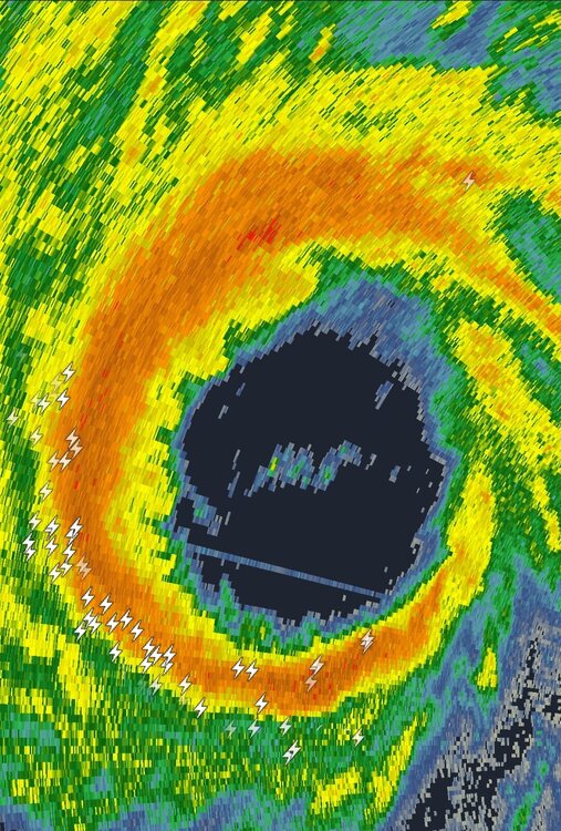
Prolific lightning right now in west to sw eyewall. One of the craziest I seen
-
Yeah I'm skeptical of any major increases in strength. Esp now that it has increased in size. The pressure drops later could go more into expanding wind field instead of strengthening it, at least initially. Not saying 130 isn't achievable but thinking 120-125 is more likely.
-
That's kind of conflicting based on satellite presentation improving. Interesting. I guess still residual effects from EWRC. May be a while before we see any intensification or maybe not potentially. Radar presentation now is amazing and lightning going nuts in sw eyewall
-
SE eyewall convection not overly impressive right now potentially leftover effects from EWRC or possible dry air intrusion. However, lightning ramping up in southern and northern eyewall.
-
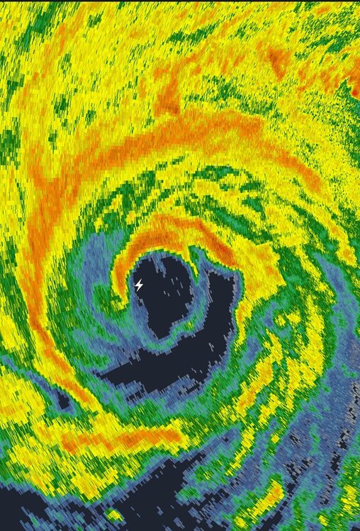
EWRC looks almost complete. At least from radar perspective. Eye has filled in on IR satellite for now. Satellite presentation has temporarily degraded some but could see it start improving as it reorganizes overnight. Shear is the potential fly in the ointment. I'm thinking winds might be down on next recon and pressure either steady or up.
-
What site do you get these on? Been trying to find it. I just tried address under picture and it didn't work
-
EWRC looks well underway on radar with secondary eyewall really enveloping inner eyewall with degradation of inner eyewall seen. Pretty impressive if we're still seeing pressures dropping that much with this occurring.
-
I totally agree and wasn't trying to bash them in anyway. Very tough forecast they had for strength and track. That was just my opinion.
-
It's possible, but after tonight Ian will be out of warmest waters albeit will still be in plenty warm water and will be encountering increasing shear so not sure how much that will mitigate strengthening
-
I'm skeptical on their 130mph landfall in FL. Not sure Ian will be able to achieve this with this EWRC that may take a while and if that opens up the core or makes it unstable it could subject it more the the shear that's beginning to impact it. Hard to say. SE part of inner eyewall really degrading now.
-
Really shocked Ian stayed at same winds and pressure. Maybe EWRC is happening and it's leveling off for now. We shall see. Curious if it will hit cat 4 now because of this. Doesn't have a huge window now of ripe conditions for strengthening.
-
It's possible. That seems exceptionally high. But I do think it should be 125-130 on next update maybe
-
Okay I may be wrong. Recon just got 117knt sfc wind in northern eyewall
-
I'm not so sure. A lot of the pressure drop has went into expanding wind field instead of strengthening wind field. But I do think we will see an increase in winds on next advisory. Maybe 125-130mph.