cyclone77
-
Posts
18,066 -
Joined
-
Last visited
Content Type
Profiles
Blogs
Forums
American Weather
Media Demo
Store
Gallery
Everything posted by cyclone77
-

Winter 2024-25 Medium/Long Range Discussion
cyclone77 replied to michsnowfreak's topic in Lakes/Ohio Valley
Has anyone posted the Farmers Almanac outlook yet? -
Bone dry here as the precip has stalled about 5 miles to the west. Should remain dry here for another few hours while the QC gets hammered with ice. Still looks like 1/3" or so of mostly plain rain this afternoon.
-
DVN with an ice storm warning for Cedar Rapids and surrounding areas tomorrow. Isolated area there will get precip early enough before it warms above freezing, and may amount to some decent glazing. Looks like about 1/3" of 34 degree rain for this area tomorrow.
-
Had virga overhead all day as top-down saturation slowly evolved. Managed a few flurries mid-afternoon. Ice potential here looks null for Sat, as precip will hold off until after we reach above freezing on Sat.
-
Picked up 0.3" of snow this morning, up to 0.7" for the season. MLI did better inside the main swath and picked up 0.9", 1.3" for season. DVN just 0.4" today.
-
Winter 2024-25 Medium/Long Range Discussion
cyclone77 replied to michsnowfreak's topic in Lakes/Ohio Valley
Wonder if Green Day's working on a new song titled Wake Me Up When December Ends? -
Winter 2024-25 Medium/Long Range Discussion
cyclone77 replied to michsnowfreak's topic in Lakes/Ohio Valley
The little rainer on Saturday will wash some of the salt and grime off the roads and neglected vehicles, so that's nice. Hopefully we can dust the ground tomorrow with a quick hitting snow shower or squall. -
MLI hit 56 today, which was about 10 degrees higher than forecast. Point for tomorrow has 55, so will likely be 60-65 under full sun again.
-
Winter 2024-25 Medium/Long Range Discussion
cyclone77 replied to michsnowfreak's topic in Lakes/Ohio Valley
Decembers sure are lol worthy anymore. We've definitely established a tradition the past several seasons. Exciting times ahead..
-
Glad we finally shook this worthless northwest flow CAD regime. 50s tomorrow and Sunday. If it ain't gonna snow then give me warmth fo sho
-
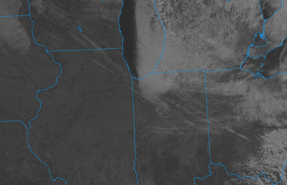
Pretty cool sat pic from this morning showing the snow squall trails from last night.
-
Winter 2024-25 Medium/Long Range Discussion
cyclone77 replied to michsnowfreak's topic in Lakes/Ohio Valley
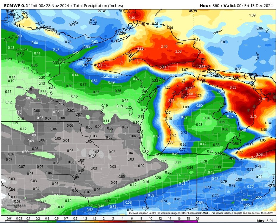
MLI with 0.4" for the season so far, and a departure of -3.1". Dubuque with 0.6", a departure of -4.1". -
Winter 2024-25 Medium/Long Range Discussion
cyclone77 replied to michsnowfreak's topic in Lakes/Ohio Valley
Looks like a chance for some flurries next Wednesday, and maybe a rainer around the 16th. Looking pretty benign through xmas. -
Cedar Rapids ASOS gusted to 66mph, MLI just hit 58mph. Just roaring out there.
-
Very impressive indeed
-
Getting close to wind warning criteria, with gusts pushing 55mph. Had a few sprinkles earlier with frontal passage. EDIT: DVN just gusted to 56mph. EDIT2: Chicago Midway apt just gusted to 58mph.
-
Haven't been above freezing since last Wednesday. Should finally go back above tomorrow afternoon.
-
MLI/DVN both finally got their first measurable snowfall today, both with 0.4". Picked up 0.3" here.
-
Winter 2024-25 Medium/Long Range Discussion
cyclone77 replied to michsnowfreak's topic in Lakes/Ohio Valley
January gonna be rockin' -
November 2024 General Discussion
cyclone77 replied to SchaumburgStormer's topic in Lakes/Ohio Valley
Coldest temp of the season so far this morning with 10. -
Winter 2024-25 Medium/Long Range Discussion
cyclone77 replied to michsnowfreak's topic in Lakes/Ohio Valley
There are many of us on the outside of this clipper pattern though. It's early and of course our time will eventually come, but this feels like a giant waste of cold for some of us in the sub. -
November 2024 General Discussion
cyclone77 replied to SchaumburgStormer's topic in Lakes/Ohio Valley
Had a burst of flurries mid-morning before it cleared off. -
Winter 2024-25 Medium/Long Range Discussion
cyclone77 replied to michsnowfreak's topic in Lakes/Ohio Valley
The clipper next Wednesday could be decent from WI down to MI/OH. Looks like that's the only clipper we have to work with in this northwest flow regime. -
Winter 2024-25 Medium/Long Range Discussion
cyclone77 replied to michsnowfreak's topic in Lakes/Ohio Valley
At least the cold northwest flow will bring mood flakes to those fortunate to be downwind of the GL. -
Fall/Winter '24 Banter and Complaints Go Here
cyclone77 replied to IWXwx's topic in Lakes/Ohio Valley
Yeah December is a throwaway month anymore. Guess we'll wait till January per usual.