cyclone77
-
Posts
18,066 -
Joined
-
Last visited
Content Type
Profiles
Blogs
Forums
American Weather
Media Demo
Store
Gallery
Everything posted by cyclone77
-
Made it to 50 here, MLI hit 51. DVN has 52 in the point for tomorrow and Tue. Will bust low pretty badly.
-
Temps overachieving again as the last of the snow melts away. Should make a run at 50 today, and it now looks like 60 is attainable both tomorrow and Tuesday. Probably in the 60s on Friday. So long POS winter.
-
Temps overachieved here today, made it to 35. 50s Monday and maybe pushing 60 Tue and Wed.
-
Today's -4 here was our 7th subzero day of the month. Had 6 days in January, so 13 total for the season. Coldest was -14 back in January.
-
@JoMo
-
One more below zero day tomorrow, then sayonara to all this arctic BS. Looking forward to the 50s next week. Zero snow in sight the next 10 days.
-
High clouds never cleared the area and cut into max cooling potential a bit. Still managed to get down to -12 so far. Looking like a nice streak of 50s starting Monday next week. May even make a run at 60 Wednesday. Should take care of this 2-3" snowpack very quickly. Thinking we have a good chance at overachieving temps as we head into March with such a widespread dry landscape. Hopefully 70s are less than a month away.
-
Temps overachieved here this morning with -7. Good chance we make a run at -15 tonight for the coldest night of the season. Coldest so far was -14 back on Jan 21st.
-
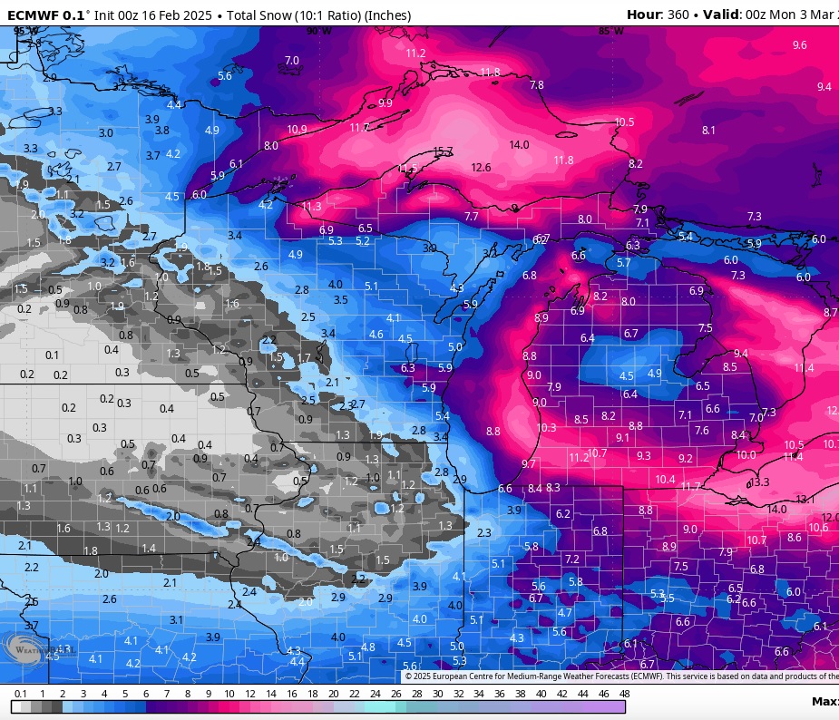
Looking basically snowless going forward into early March from this area northwestward. Mason City is doing even worse than MLI (which has 6.7" currently) with only 3.4" for the season. That's about 26" below normal. I couldn't find what the all-time least snowy season was for Mason City on the Des Moines WFO site, so not sure what they'll need to break that record. It's all going to come down to whether or not we can sneak through March/early April without too many nickel and dimers. Now that we've made it this far I want to break that futility record, but if a major snowstorm were to end that possibility I'd be okay with that I guess.

-

Fall/Winter '24 Banter and Complaints Go Here
cyclone77 replied to IWXwx's topic in Lakes/Ohio Valley
I too am ready for Spring and thunderstorms. -
Getting some bursts of mood flakes from time to time, which is nice to see. There is about 3" of fairly fresh powder on the ground, so actually looks like deep winter out there for the first time all winter. Should be just enough snow cover to maximize the chill in coming days.
-
Nailed it
-
Fall/Winter '24 Banter and Complaints Go Here
cyclone77 replied to IWXwx's topic in Lakes/Ohio Valley
Yeah the tracking was pretty fun, but overall it was kinda meh. Still a lot of red numbers on this map unfortunately, even after the busier pattern. EDIT: Also looks like it's been a bummer winter up where Bo is. Haven't seen him around here for awhile, guessing he quit the site again?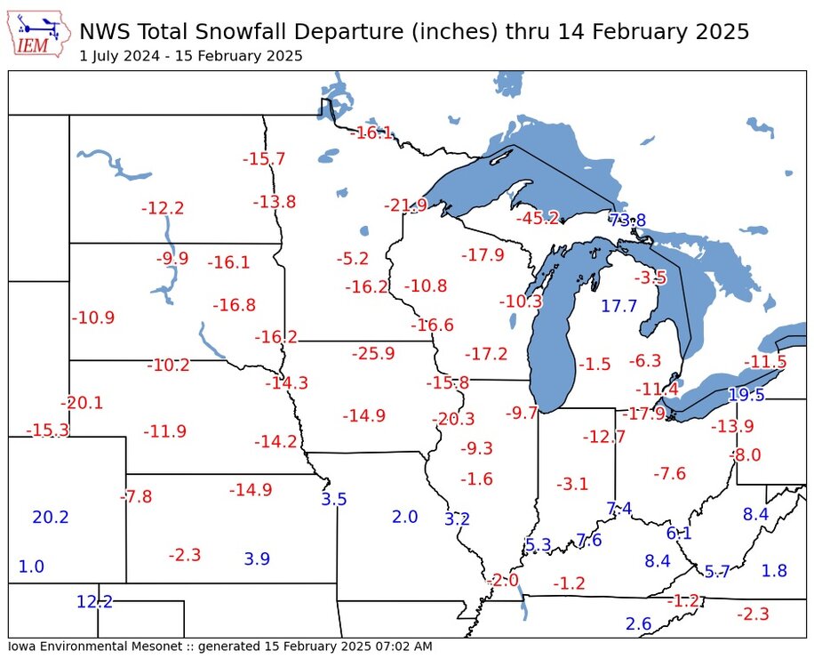
-
Was pretty legit out there for awhile with that WAA bump. Picked up a quick inch with some nice near-blizzard action out in the open country. As expected tomorrow looking like a strung out POS, so additional snowfall prob <1" for this area.
-
-6 here this morning, but have already bumped back up to 1 above as WAA has commenced.
-
Gonna stick to my original 1-2" call for here/QC. Normally sort of a non-event, but should make it the 2nd best event of season.
-
Fall/Winter '24 Banter and Complaints Go Here
cyclone77 replied to IWXwx's topic in Lakes/Ohio Valley
Back on the futility hype train for me. Gotta have something to root for right? Just gotta make it through the next 5-6 weeks without too many nickel and dimers. -
Starting to look kind of DABish to me for this area. WAA looks like it has weakened or shifted north compared to earlier model cycles which clobbered us with potent band of intense WAA snows. The Saturday stuff looks like a strung out POS mess until things organize off to the east.
-
Wish I could buy into what the FV3 is selling lol
-
3.3" the total here, up to 8.3" for the season. 2.3" at MLI, up to 5.9" for the season. 4.5 at DVN, up to 10.8" for the season.
-
I'll go 1-2" first guess. That's with 1st wave. Like Hawkeye I have low expectations with main wave. Prob DAB or heavy overcast with that part.
-
No that's probably what's coming for Iowa City and Cedar Rapids
-
Around 3 inches now here. This final band is holding on nicely
-
Since today's system significantly underperformed compared to how it was looking a few days ago futility is still technically on the table for MLI. So far today they've officially picked up only an inch. Will probably end up with <3" for the storm total, which will keep seasonal total <6.5". With the way things are going the Fri-Sat system will find a way to miss or underperform. After that who knows how things go.
-
Best snowfall of the day right now. Maybe we can tack on an inch before the back end sweeps through.