cyclone77
-
Posts
17,843 -
Joined
-
Last visited
Content Type
Profiles
Blogs
Forums
American Weather
Media Demo
Store
Gallery
Everything posted by cyclone77
-
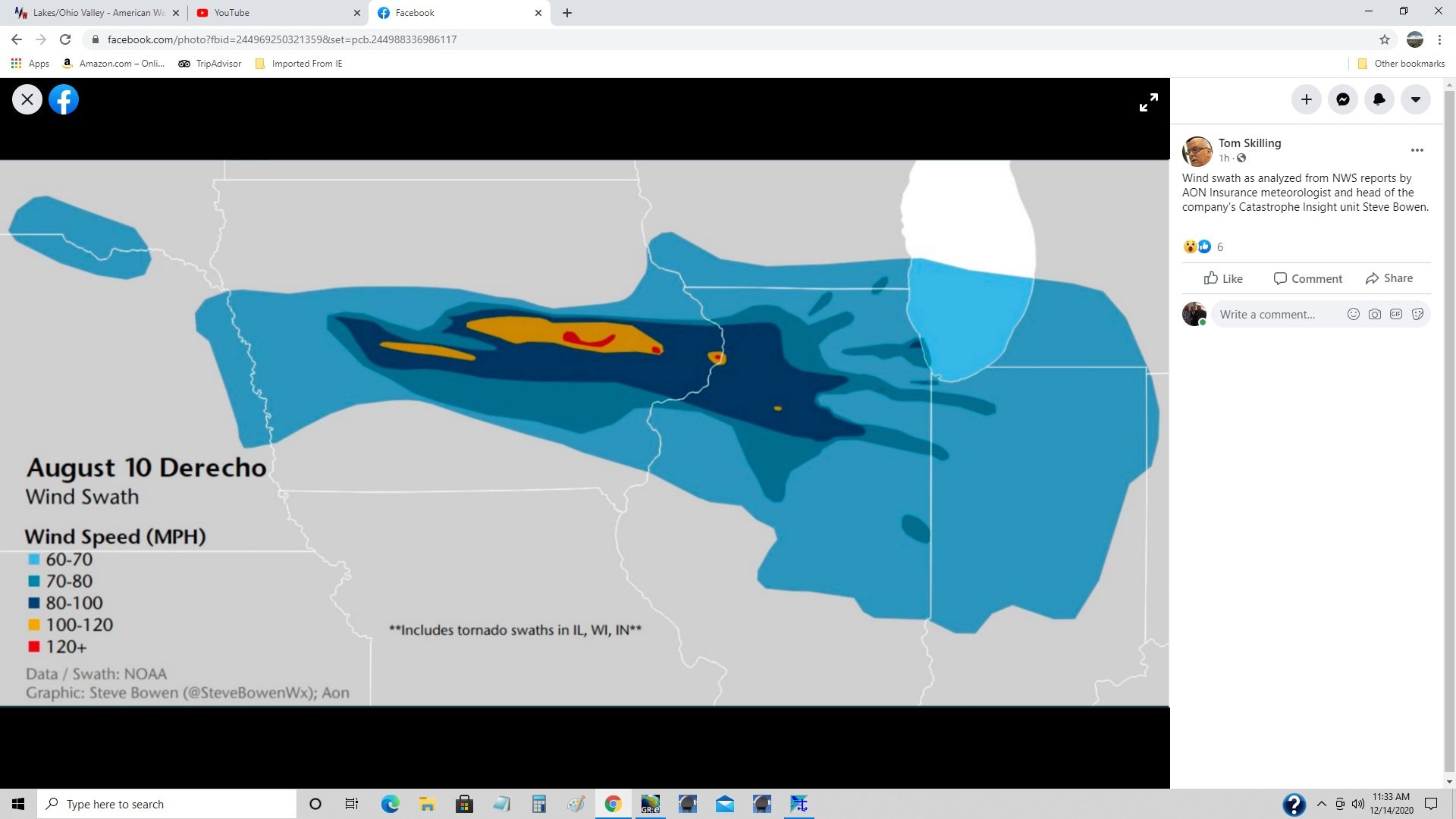
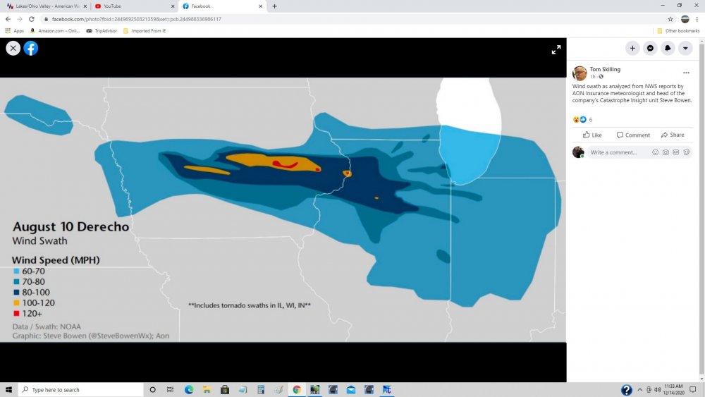
The August 10th derecho is the event of the year here, and is the most impressive single weather event I've ever personally experienced while at home. 60-80+mph winds that lasted over an hour, and no power for 92 hours. Might have been the only time I actually felt afraid of the weather while being at home, mostly because of not knowing exactly how much worse it could get. Reports upstream were pretty scary. We got off pretty easy compared to places along the main swath like Cedar Rapids, and across the river in Clinton. Hawkeye and others definitely had it WAY worse than what we got. Still can't believe how long those high winds lasted. What will probably always stick with me about this event is how no matter where you went you were always coming across huge trees down/uprooted now and again. In most cases around here after a severe event while driving around you'll come across a swath of 1-3 miles wide of trees down, or uprooted. With this event it was wherever you went, and in some places whole groves of trees were destroyed/uprooted.
-

Winter 2020-21 Medium/Long Range Discussion
cyclone77 replied to Hoosier's topic in Lakes/Ohio Valley
February will be rockin' -
Was in the IL QC earlier this evening. There's still snow on the ground leftover from last Saturday's snow even after a few days in the 40s. There's actually more snow leftover on the ground there than we've had all season to date here.
-
-
As RC and many others have pointed out in the mid-range thread there's growing potential for something a little more substantial Wed night into Thursday (Christmas Eve). May be a bit of a thread-the-needle event depending on how it phases, but hopefully a lucky swath could pick up some fresh snow just in time for Christmas.
-
Winter 2020-21 Medium/Long Range Discussion
cyclone77 replied to Hoosier's topic in Lakes/Ohio Valley

-
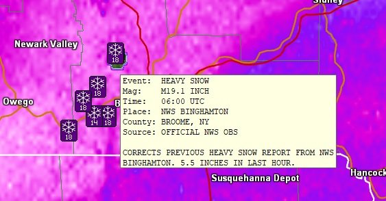
Posted in Dec thread, but there's a report of 5.5" in one hour at BGM.
-
Winter 2020-21 Medium/Long Range Discussion
cyclone77 replied to Hoosier's topic in Lakes/Ohio Valley
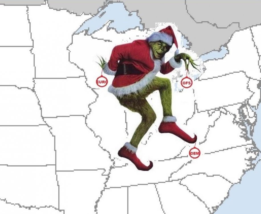
New Euro continues to look bleak for the western half of the sub through late Dec. Luckily March and April will make up for the no-show December per usual lol.
-
Not in this sub, but some extreme rippage going on right now out east. One report near Binghamton NY had 4.5" in the past hour, and another had 5.5". Extremely impressive especially for it coming from system snow and not LES.
-
I believe I saw a flurry whiz by walking out to my vehicle after work.
-
Have flurries in the point tomorrow and tomorrow night. Mood flakes to at least make it look a little more like winter at least.
-
Winter 2020-21 Medium/Long Range Discussion
cyclone77 replied to Hoosier's topic in Lakes/Ohio Valley
Wake me up in January. -
Current snow cover. Illustrates the 3-5" that fell just south of the QC sat, and nada here. Cruel, cruel storm system lol.

-
Fresh snow cover allowed Monticello IA to get way down to 3 above early this morning. Dubuque got down to 7.
-
That was at work but I got to watch all of it fall which was great.
-
A small area of light snow came through earlier this evening and brought our first accumulation for the day with 0.3". Enough to bump us over the 1" mark for the season.
-
December 11th-12th Potential Winter Storm
cyclone77 replied to Thundersnow12's topic in Lakes/Ohio Valley
I see there was a 5" report just south of the QC, wow! I'm guessing the areas that saw accumulation had a period of large flakes to develop a quick base on which to accumulate. The areas that didn't have that saw little or no accum. -
December 11th-12th Potential Winter Storm
cyclone77 replied to Thundersnow12's topic in Lakes/Ohio Valley
Had almost 2" of snow at work, got home just now and the ground is completely bare. It ripped at work with large flakes for a good hour. Finished with 1.08" of rain. -
December 11th-12th Potential Winter Storm
cyclone77 replied to Thundersnow12's topic in Lakes/Ohio Valley
Driving rain pounding the east windows as winds gust over 30mph at times. 37 degrees. Picked up 0.68" so far. -
December 11th-12th Potential Winter Storm
cyclone77 replied to Thundersnow12's topic in Lakes/Ohio Valley
^ Just brutal for the QC/Chicago corridor. So close yet so far away lol. -
December 11th-12th Potential Winter Storm
cyclone77 replied to Thundersnow12's topic in Lakes/Ohio Valley
Solid call. I'd hope for more since you should be in the heart of it tonight/tomorrow morning, but given how things have been going 3" would be just fine. Wouldn't be surprised if you, or somewhere close by got 5"+ though. -
December 11th-12th Potential Winter Storm
cyclone77 replied to Thundersnow12's topic in Lakes/Ohio Valley
We're underway here with our first 0.01" of rain, and 41 degrees. Looks like a steady cold rain through about 6-7am before a quick changeover to snow. Was thinking/hoping 1-3" but I think we'll do good if we can squeeze an inch out of this. At least we should get over the 1" seasonal hurdle with this. The Des Moines to Cedar Rapids corridor def has the hot hand, as many areas along that track will loft to over 10" for the season with this. -
December 11th-12th Potential Winter Storm
cyclone77 replied to Thundersnow12's topic in Lakes/Ohio Valley
Gonna go with 1-3" for here and the QC. Looks like quite a bit of rain to fall as well, perhaps a good inch. Euro wraps in some pretty nice deform bands during the day Sat, so it may look pretty legit out there for a time. -
Yeah today was fantastic. MLI set a new record high of 62 today beating the old one of 60. Hit 59 here. Took the opportunity to plant one more tree (willow oak).
-
MLI and ORD are tied at 0.7". All of that 0.7" at MLI fell in Oct, and all of the 0.7" at ORD fell in Nov. Kind of interesting/depressing lol.