LVblizzard
-
Posts
4,476 -
Joined
-
Last visited
Content Type
Profiles
Blogs
Forums
American Weather
Media Demo
Store
Gallery
Everything posted by LVblizzard
-
Philly weenies are gonna faint when they see the RGEM...
-
That’s over 36 hours straight of snow. Super long-duration storm is back on the menu!
-
I just posted 4-8” for the Lehigh Valley on my page but I stressed that confidence is low.
-
NAM looks like it’s a tick south.
-
The Euro run definitely eased some of my anxiety. It doesn’t look like a total whiff is a realistic solution here in the Lehigh Valley. Now the question is, is this a run of the mill 3-6” storm or will it be much more significant?
-
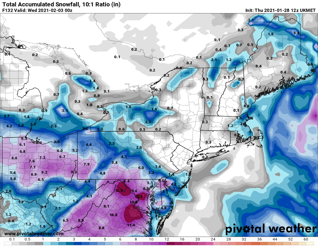
UKMET crushes most of the area. Very sharp cutoff north of the Lehigh Valley though. Allentown sees close to a foot while Jim Thorpe and Hazleton only get an inch or so.
-
Seems like we’re near the cutoff with so many storms. It only takes a small change for us to go from 12-18” to 2-4” here with this one.
-
Remember, the Euro was the southern outlier with the Jan. 2016 storm too. I remember it came close to whiffing Philly for a few runs.
-
Happens on the RGEM too which has a very similar look to the NAM at the end of its run.
-
NAM looks very good. Would probably be a decent hit for most of us if extrapolated.
-
The trend within 3 days this winter has been to weaken the confluence, resulting in a more north storm. Even if 0z models keep going south this is far from over.
-
I wonder if there’s a chance that phases in?
-
Euro ensembles are getting a little iffy for northern areas. Really hope that trend stops.
-
Model consensus is very, very good if you take away the UKMET.
-
The UKMET is the nightmare scenario.

-
There’s a clear trend south from tonight to this afternoon with the location of the coastal low. Reminds me of tracking the Jan. 2016 storm. One more shift south and I might start to get a little worried here in the Lehigh Valley.
-
Euro torches the turnpike for like 6 hours, that’s why totals are lower there. Still a great run.
-
Really liking where I'm at in the Lehigh Valley...even the warmer solutions with some mixing still give us 6-10" here. Gonna be nice to enjoy a long-duration storm all the way from Sunday to Tuesday.
-
Everybody wins on the Euro! Solid foot or so for most of us. And there is potential for it to be even more epic too.
-
It all depends on how much energy swings around the base of the trough. If there’s a lot, the low tucks into the coast and that CCB does form. If the energy is just loose and all over the place, the initial thump may be nice but Monday and Tuesday’s snow will be pretty light for the most part as the ULL swings through.
-
Seems like this isn’t the storm for those hoping for 2-3”/hr rates and thundersnow...but if you like steady light to moderate snow for days, you’ll love this storm.
-
January 25-27 Light Wintry but Long Duration Event obs
LVblizzard replied to ChescoWx's topic in Philadelphia Region
A coating of snow and sleet remains in the Lehigh Valley tonight. Probably gonna melt tomorrow. -
GFS snows for over two days straight here. Mother of God!!!
-
GFS thermals are useless. If there’s a huge CCB like that it will most likely be snow.
-
January 25-27 Light Wintry but Long Duration Event obs
LVblizzard replied to ChescoWx's topic in Philadelphia Region
Snow/sleet mix in Bath. Huge flakes. We have a dusting on the ground already.