LVblizzard
-
Posts
4,477 -
Joined
-
Last visited
Content Type
Profiles
Blogs
Forums
American Weather
Media Demo
Store
Gallery
Everything posted by LVblizzard
-
Steady light to moderate snow has been falling in the Lehigh Valley since 8 am when I woke up.
-
Why does greenskeeper slap weenie reactions on like half the posts on here? Lmao
-
Looks like about 4-5” or so. I’m at work and there’s no ruler (or reliable measuring spot for that matter) here.
-
Staying all snow here in Bath...for now. Hopefully the back edge arrives before a changeover to sleet can happen.
-
Moderate to heavy snow 8 miles north of Bethlehem in Bath. Coming up on 2” here.
-
Gonna be interesting to see how this storm ends up evolving. The NAM has a big front end thump and then a bunch of snizzle. While the GFS and RGEM just give us a nice long-duration event with lots of light to moderate snow.
-
18z NAM with a huge front end thump for the Philly burbs into the Poconos.
-
Damn...you beat me with this thread by seconds. I’m really liking this event for a good front-end thump...maybe a general 4-8” or 5-10” for the area. It seems like the kind of storm where the front-end snow overperforms while the rest of the storm is just occasional frozen IP/ZR junk. Fortunately the models aren’t big on significant icing for this one.
-
With surface temps this cold, we need this to be all snow. Sleet/ZR at 15-20F would not be pleasant.
-
Moderate snow in Allentown. About an inch has fallen so far.
-
Very fine light snow in Allentown. This is the kind of snow you can sweep away instead of shovel.
-
Pretty much the only way to go is to create a local weather page as a side hustle and maybe charge for subscriptions or get ad revenue once you get big enough. Even then it’s a huge uphill battle - I’ve been running my weather page for over 10 years and I’m still not ready to monetize anything.
-
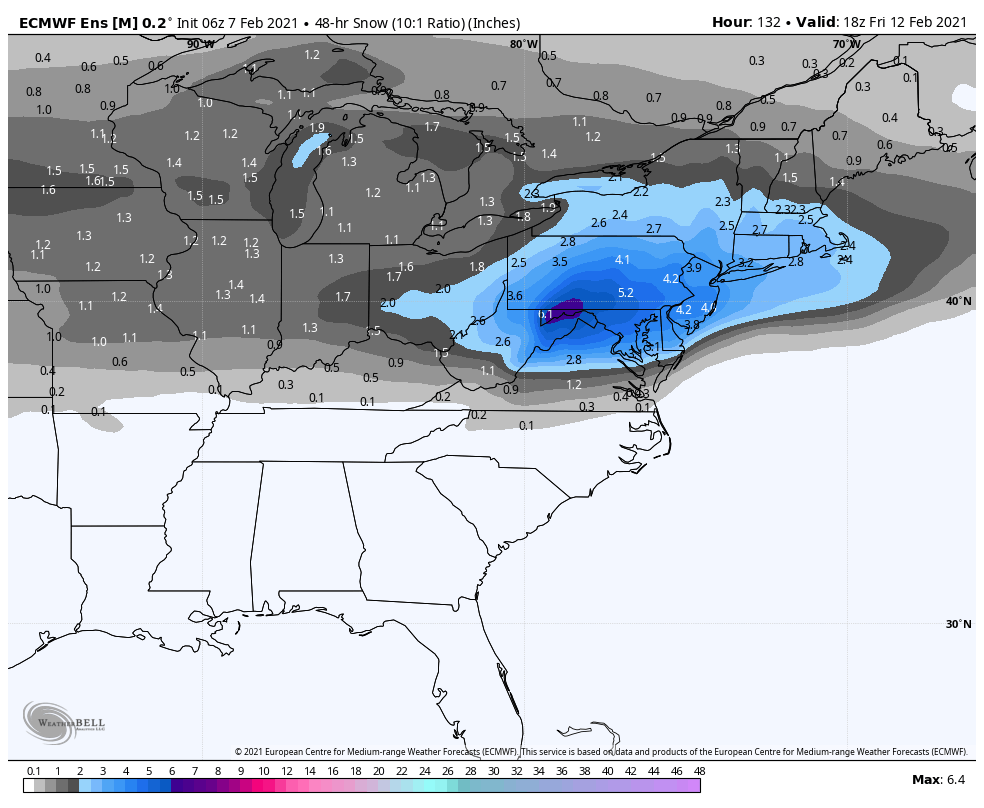
Here we go again... At this point models all agree on a bunch of overrunning snow starting Wednesday night and lasting into at least Thursday morning. But from there it gets tricky. Some models want to bring the shortwave north, resulting in more freezing rain, while others want to keep it south, giving us yet another nice snowstorm. Regardless, it looks like we’ll have some more wintry precip later this week. Here’s last night’s Euro ensemble mean for this time period. Definitely something to keep a close eye on.

-
I’m thinking a general 3-6” for the region with a stripe of up to 10” along or near I-95.
-
January 31-February 2, 2021 Major Winter Storm Observations
LVblizzard replied to Ralph Wiggum's topic in Philadelphia Region
Unbelievable...this is the storm that will not end. Woke up and there’s still steady light snow here in Allentown. -
January 31-February 2, 2021 Major Winter Storm Observations
LVblizzard replied to Ralph Wiggum's topic in Philadelphia Region
Looks like Nazareth ended up eclipsing the 3 foot mark. 36.1” officially reported there. Insanity!! -
January 31-February 2, 2021 Major Winter Storm Observations
LVblizzard replied to Ralph Wiggum's topic in Philadelphia Region
Still some flakes in the air in Allentown...over 55 hours after the first flakes! Unbelievable duration with this storm. -
January 31-February 2, 2021 Major Winter Storm Observations
LVblizzard replied to Ralph Wiggum's topic in Philadelphia Region
Woke up and it feels like I’m in a lake effect snow belt with how it looks outside. Over 2 feet on the ground with steady light snow. -
January 31-February 2, 2021 Major Winter Storm Observations
LVblizzard replied to Ralph Wiggum's topic in Philadelphia Region
I’m 6 miles NE of ABE and it’s still moderate snow. -
January 31-February 2, 2021 Major Winter Storm Observations
LVblizzard replied to Ralph Wiggum's topic in Philadelphia Region
Wish I knew! I’m stuck at work and I don’t have access to a yardstick here, unfortunately. -
January 31-February 2, 2021 Major Winter Storm Observations
LVblizzard replied to Ralph Wiggum's topic in Philadelphia Region
This band over the Lehigh Valley isn’t even moving. Guarantee somewhere approaches 3 feet. -
January 31-February 2, 2021 Major Winter Storm Observations
LVblizzard replied to Ralph Wiggum's topic in Philadelphia Region
Has to be blizzard conditions in the Lehigh Valley right now. Heavy snow and the wind is as strong as it’s been. -
January 31-February 2, 2021 Major Winter Storm Observations
LVblizzard replied to Ralph Wiggum's topic in Philadelphia Region
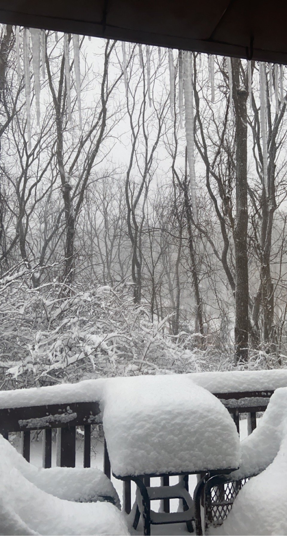
The back deck at work in Bath, PA right now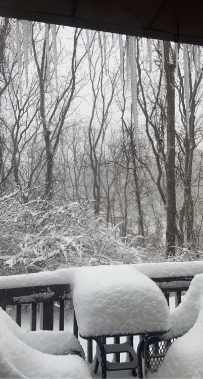
-
January 31-February 2, 2021 Major Winter Storm Observations
LVblizzard replied to Ralph Wiggum's topic in Philadelphia Region
Under the deform band...getting crushed! -
January 31-February 2, 2021 Major Winter Storm Observations
LVblizzard replied to Ralph Wiggum's topic in Philadelphia Region
I don’t have a ruler at work unfortunately and I can’t really tell since we’ve already shoveled a few times and there’s piles everywhere.