LVblizzard
-
Posts
4,477 -
Joined
-
Last visited
Content Type
Profiles
Blogs
Forums
American Weather
Media Demo
Store
Gallery
Everything posted by LVblizzard
-
E PA/NJ/DE Spring 2022 OBS Thread
LVblizzard replied to Hurricane Agnes's topic in Philadelphia Region
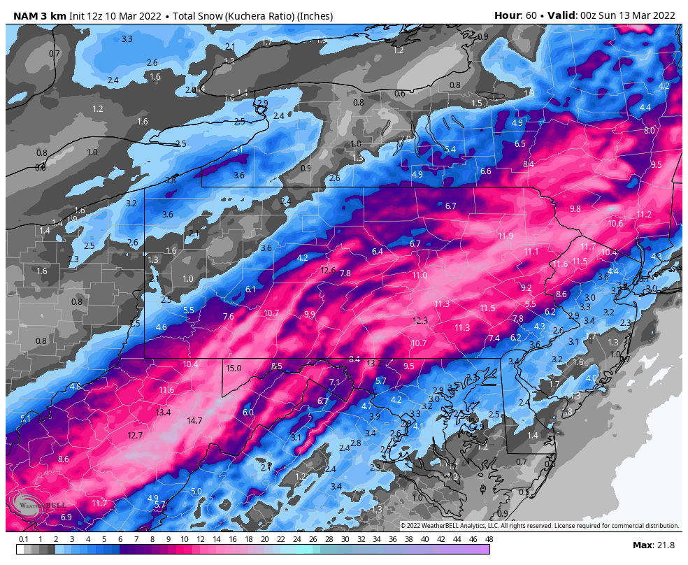
12z 3km NAM has some pretty big snows along I-78 and I-80.
-
Snow is coming down pretty good and starting to accumulate near Allentown.
-
E PA/NJ/DE Spring 2022 OBS Thread
LVblizzard replied to Hurricane Agnes's topic in Philadelphia Region
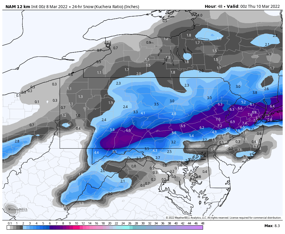
0z NAM has a pretty nice event for the Lehigh Valley and southern Poconos on Wednesday.
-
E PA/NJ/DE Spring 2022 OBS Thread
LVblizzard replied to Hurricane Agnes's topic in Philadelphia Region
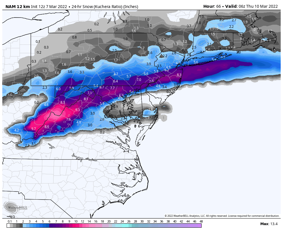
12z NAM comes in with the most weenie solution yet. This is something to watch…the NAM nailed the “surprise” event last month.
-
Feb 24-25th Event -- Generators for some, pre-emerg for others
LVblizzard replied to JTA66's topic in Philadelphia Region
Sleeting hard near Allentown. Ground is covered. -
Feb 24-25th Event -- Generators for some, pre-emerg for others
LVblizzard replied to JTA66's topic in Philadelphia Region
ZR/sleet mix a few miles west of Allentown. -
There’s a pretty good signal for this on the GFS and CMC ensembles. Definitely bears watching.
-
Radar is looking pretty nice. Precip is breaking out earlier than the models showed and there’s a heavy band almost back to State College. I have a feeling some of us will be waking up very happy in the morning.
-
In a big way too. 3-6” region-wide with up to 8” in a few areas.
-
The south trend is real with this one. That 1040+ high in southern Canada means business.
-
January 28th/29th Event Obs - From KU to FU?
LVblizzard replied to JTA66's topic in Philadelphia Region
Heaviest snow of the storm so far in the Lehigh Valley. Still not “heavy” snow by definition but it’s coming down at a pretty good clip. -
January 28th/29th Event Obs - From KU to FU?
LVblizzard replied to JTA66's topic in Philadelphia Region
Cutoff will probably hang out in Berks, into Schuylkill and Carbon counties overnight. I’m glad to be east of it even if I’m not getting in on the good stuff. -
January 28th/29th Event Obs - From KU to FU?
LVblizzard replied to JTA66's topic in Philadelphia Region
On my drive home to the Allentown suburbs it was snowing steadily, but lightly, the whole time. Snow is beginning to stick to the highways and main roads. -
January 28th/29th Event Obs - From KU to FU?
LVblizzard replied to JTA66's topic in Philadelphia Region
Each run of the HRRR just keeps getting better.
-
January 28th/29th Event Obs - From KU to FU?
LVblizzard replied to JTA66's topic in Philadelphia Region
Steady light snow at my work in Bath. Ground covered. A bit surprising given the lack of radar returns here. -
January 28th/29th Event Obs - From KU to FU?
LVblizzard replied to JTA66's topic in Philadelphia Region
Storm definitely seems more juiced so far, especially when comparing the current radar to the hot garbage that was the 18z model suite. -
January 28th/29th Event Obs - From KU to FU?
LVblizzard replied to JTA66's topic in Philadelphia Region
HRRR has been trending better throughout the evening.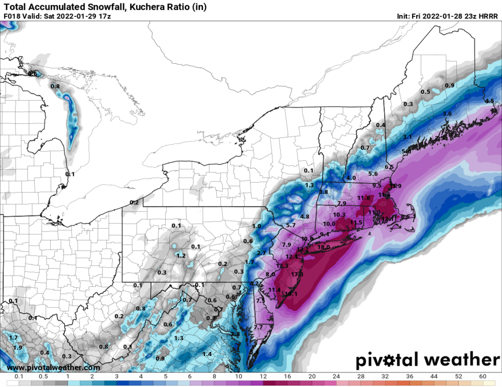
-
January 28th/29th Event Obs - From KU to FU?
LVblizzard replied to JTA66's topic in Philadelphia Region
One good thing I’m seeing is that the precip off the NC coast is quite a bit more north and west than the 18z 3km NAM showed at 4 pm.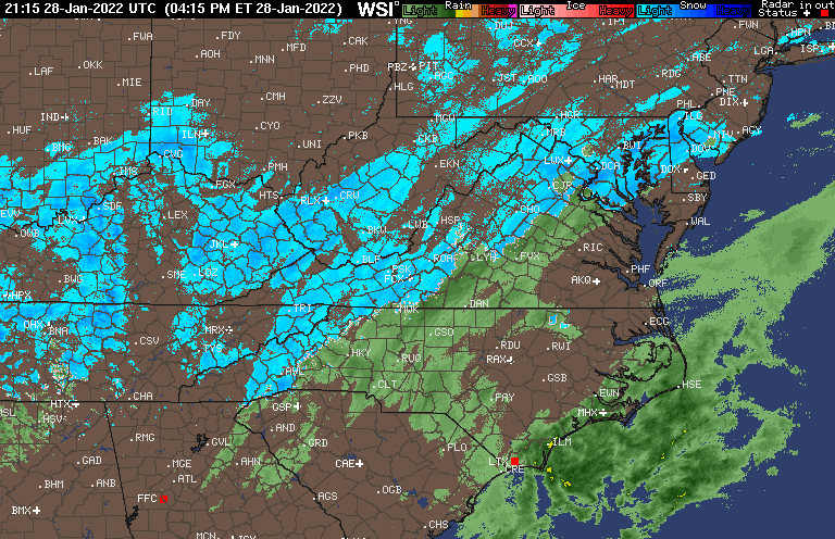

-
January 28th/29th Event Obs - From KU to FU?
LVblizzard replied to JTA66's topic in Philadelphia Region
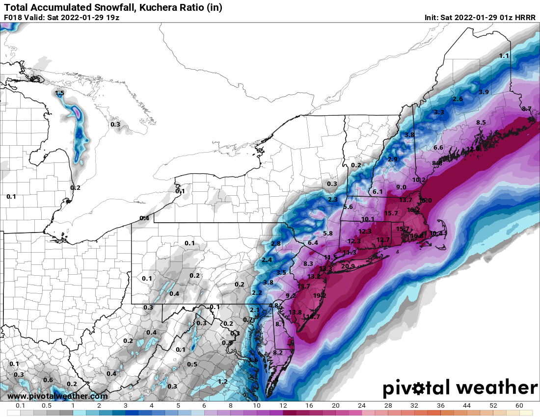
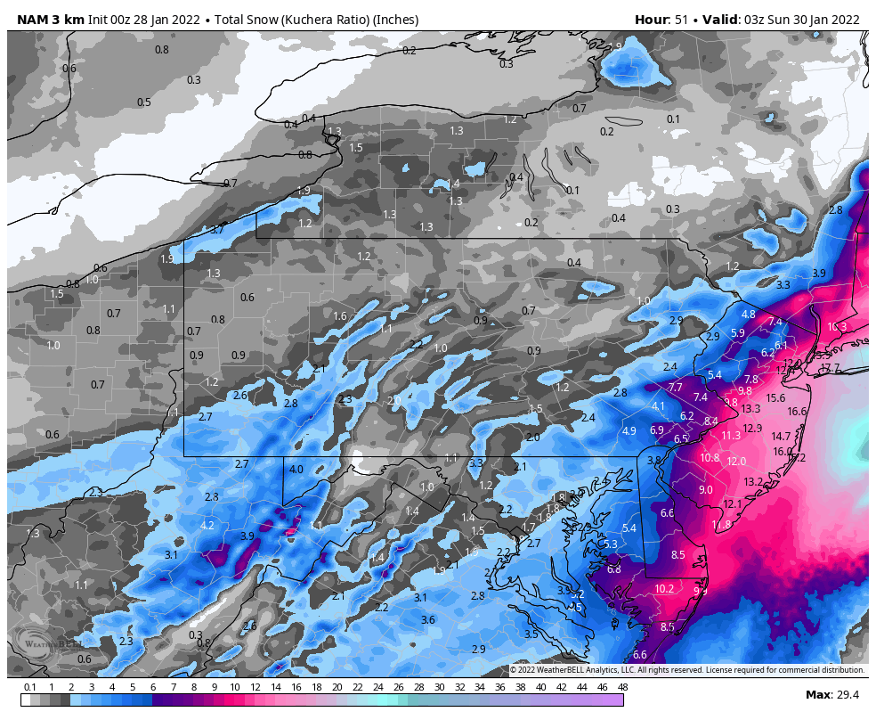
Really not liking the trends in the short-range mesos. The HRRR earlier today showed up to 4-5” in Allentown…now we’re barely seeing an inch. -
January 28th/29th Event Obs - From KU to FU?
LVblizzard replied to JTA66's topic in Philadelphia Region
Compare the 12z and 0z Euro precip maps. Very little difference in SE PA, even a bit more in eastern Bucks. It's a worse run for SNE and NYC but for us it's nothing to worry about. -
January 28th/29th Event Obs - From KU to FU?
LVblizzard replied to JTA66's topic in Philadelphia Region
Initial low confidence guess for the Lehigh Valley was 1-3"...maybe time to bump that up to 2-4" or 3-6"? Tomorrow's guidance is going to be important, as well as comparing tonight's models to tomorrow's observations in about 12-24 hours. -
January 28th/29th Event Obs - From KU to FU?
LVblizzard replied to JTA66's topic in Philadelphia Region
Regular NAM on top…and the 3km that came west as well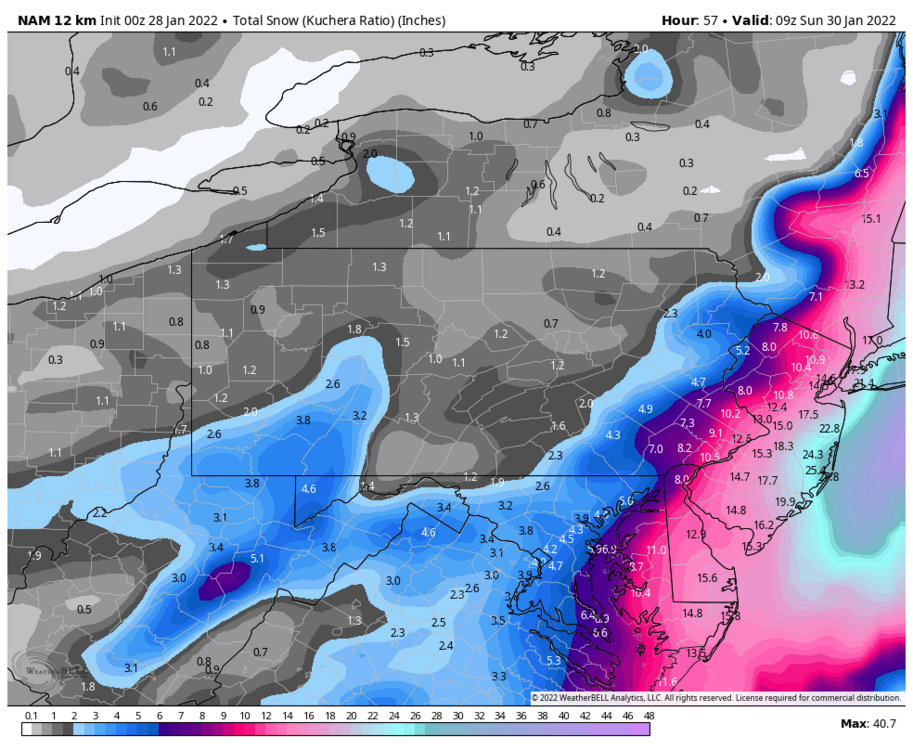

-
January 28th/29th Event Obs - From KU to FU?
LVblizzard replied to JTA66's topic in Philadelphia Region
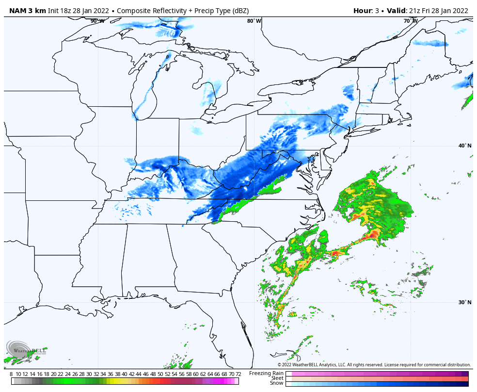
Well well well, hello there 0z NAM… -
January 28th/29th Event Obs - From KU to FU?
LVblizzard replied to JTA66's topic in Philadelphia Region
We actually have some pretty solid agreement now among the models not named the GFS. -
January 28th/29th Event Obs - From KU to FU?
LVblizzard replied to JTA66's topic in Philadelphia Region
Being in the Lehigh Valley sucks for this one…it might be one of those storms where NYC gets blasted and we just get some light snow.