LVblizzard
-
Posts
4,477 -
Joined
-
Last visited
Content Type
Profiles
Blogs
Forums
American Weather
Media Demo
Store
Gallery
Everything posted by LVblizzard
-
E PA/NJ/DE Winter 2022-2023 OBS Thread
LVblizzard replied to Ralph Wiggum's topic in Philadelphia Region
About an inch so far in Allentown. Round 1 looks like it’s about to end but the radar is improving slightly in central PA. -
E PA/NJ/DE Winter 2022-2023 OBS Thread
LVblizzard replied to Ralph Wiggum's topic in Philadelphia Region
The stuff in western and central PA looks good though. As long as the mid levels don’t torch that will bring us to our predicted totals. -
E PA/NJ/DE Winter 2022-2023 OBS Thread
LVblizzard replied to Ralph Wiggum's topic in Philadelphia Region
Can’t really see 5-8” for the LV…there’s plenty of cold air but the radar just doesn’t look good enough. I do think we see a plowable 2-4” though. Maybe up to 5” in spots. Just started snowing in Allentown. Gonna be a fun evening here. -
E PA/NJ/DE Winter 2022-2023 OBS Thread
LVblizzard replied to Ralph Wiggum's topic in Philadelphia Region
Decent storm signal on the Euro ensembles for late next week. I’m really optimistic about this one because I’ll be in California next Thursday-Sunday so if a storm happens I won’t get to experience it at all. -
E PA/NJ/DE Winter 2022-2023 OBS Thread
LVblizzard replied to Ralph Wiggum's topic in Philadelphia Region
Just started snowing in Allentown. 42F. Mid to low levels must be pretty cold if it’s over 40 with snow falling. -
E PA/NJ/DE Winter 2022-2023 OBS Thread
LVblizzard replied to Ralph Wiggum's topic in Philadelphia Region
FWIW it looks like this system is colder than modeled already in NW PA. Lots of sleet reports from Erie down to I-80 when every model had rain there at this time. -
E PA/NJ/DE Winter 2022-2023 OBS Thread
LVblizzard replied to Ralph Wiggum's topic in Philadelphia Region
Friday is looking worse by the hour…looks like tonight is our best hope here in the LV. Haven’t had an event over 2” all season, will tonight’s system finally be the one to pass that mark? -
E PA/NJ/DE Winter 2022-2023 OBS Thread
LVblizzard replied to Ralph Wiggum's topic in Philadelphia Region
Love how tomorrow night is trending colder. I just made my first call on my page, 1-3” for the Lehigh Valley…I might have to increase that a little bit if these trends continue! Also starting to get mildly excited about Friday even though I’m scheduled (for now) to drive to and from Princeton that day. -
E PA/NJ/DE Winter 2022-2023 OBS Thread
LVblizzard replied to Ralph Wiggum's topic in Philadelphia Region
I see sleet reports as far south as Delaware and the Jersey Shore. Looks like the cold air was under-modeled. -
E PA/NJ/DE Winter 2022-2023 OBS Thread
LVblizzard replied to Ralph Wiggum's topic in Philadelphia Region
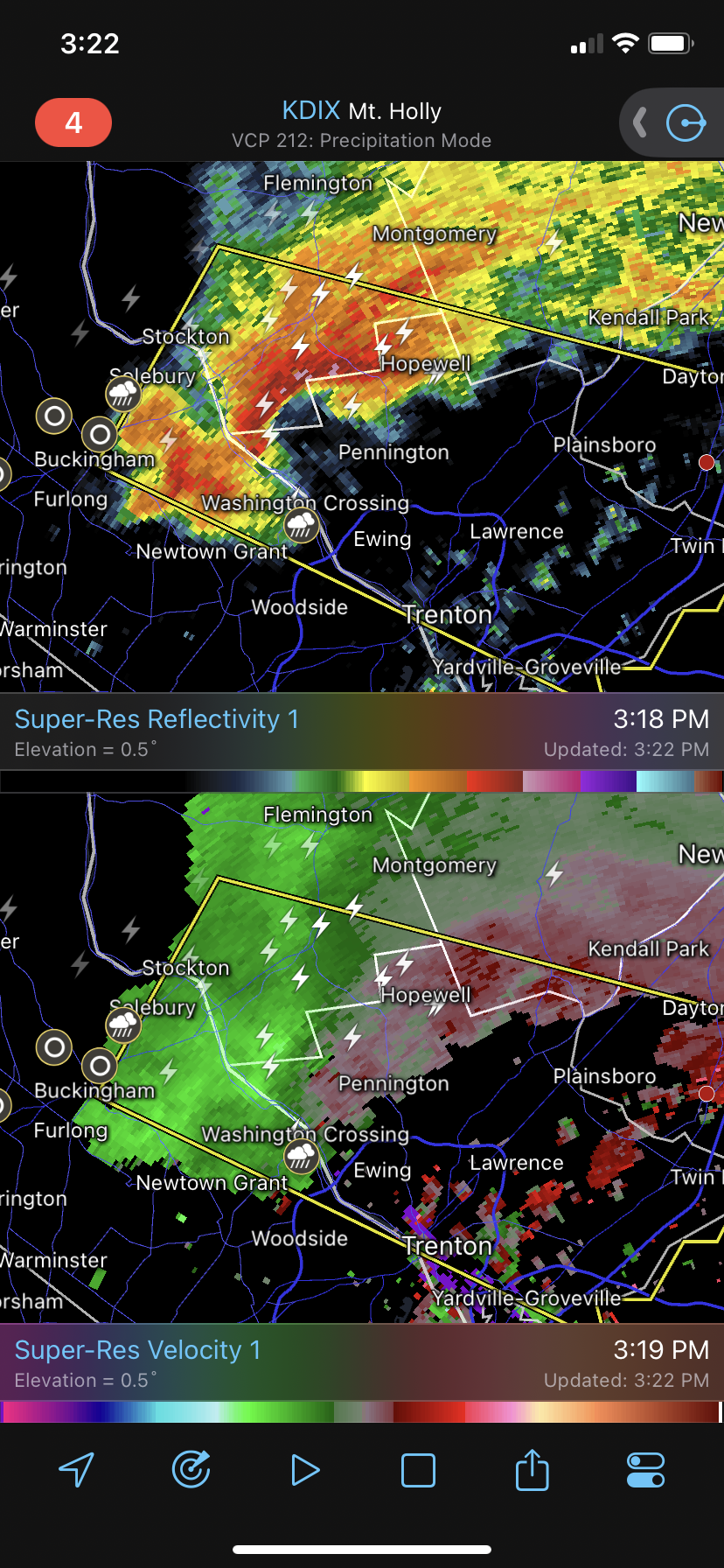
That is one nasty cell crossing into NJ right now. Even has a little hook on it.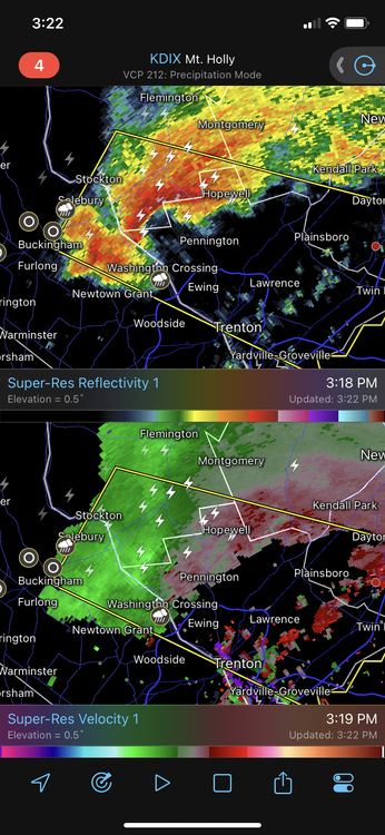
-
E PA/NJ/DE Winter 2022-2023 OBS Thread
LVblizzard replied to Ralph Wiggum's topic in Philadelphia Region
A bit of thunder here in Allentown. We’ve had more claps of thunder today than inches of snow this year. -
E PA/NJ/DE Winter 2022-2023 OBS Thread
LVblizzard replied to Ralph Wiggum's topic in Philadelphia Region
Heavy snow in Allentown. Sticking to everything. Warmer models have already busted. -
E PA/NJ/DE Winter 2022-2023 OBS Thread
LVblizzard replied to Ralph Wiggum's topic in Philadelphia Region
Snow has begun in Allentown. Looks like the R/S line is a good bit farther south than modeled so far. -
E PA/NJ/DE Winter 2022-2023 OBS Thread
LVblizzard replied to Ralph Wiggum's topic in Philadelphia Region
Driving to the PHL airport from Allentown at around 3-4 pm today. Hopefully it’s not too bad. Would have loved for this storm to come at literally any other time… -
E PA/NJ/DE Winter 2022-2023 OBS Thread
LVblizzard replied to Ralph Wiggum's topic in Philadelphia Region
Moderate snow in Allentown. Starting to stick to roofs and grassy surfaces. -
E PA/NJ/DE Winter 2022-2023 OBS Thread
LVblizzard replied to Ralph Wiggum's topic in Philadelphia Region
This winter is just absolutely brutal so far. It’s gotten to the point where all I want is a 2-3” event that stays all snow. Is that really too much to ask? -
E PA/NJ/DE Winter 2022-2023 OBS Thread
LVblizzard replied to Ralph Wiggum's topic in Philadelphia Region
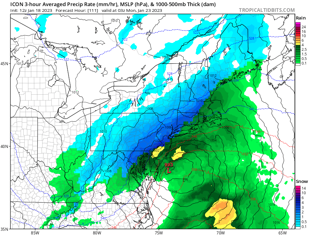
12z ICON starts off this afternoon’s model suite with a bang.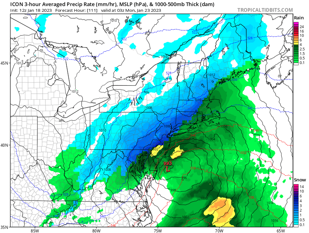
-
E PA/NJ/DE Winter 2022-2023 OBS Thread
LVblizzard replied to Ralph Wiggum's topic in Philadelphia Region
12z models have trended towards a secondary low developing on the tail end of the trough. The Euro is by far the most aggressive and the CMC and UKMET show a little bit of promise, while the GFS keeps everything well to the north. Not overly enthused about this chance but it’s something to keep an eye on. -
Currently some light to moderate snow in Bethlehem. Sticking to everything. The flakes are so fine it’s not even showing up on the radar.
-
Moderate wind-blown snow in Allentown. Sticking to grass. Can we get over an inch?
-
There’s the changeover in Allentown. Light snow with very strong winds gusting to 30-40… looks like we have 2-3 hours of this before it stops.
-
Some backbuilding going on in eastern MD and SE PA. Wouldn’t be surprised to squeeze out an inch or two in the Lehigh Valley. Still raining here but that R/S line looks like it’s racing east.
-
E PA/NJ/DE Winter 2022-2023 OBS Thread
LVblizzard replied to Ralph Wiggum's topic in Philadelphia Region
Clear east trend on the 0z models so far tonight for Thurs/Fri. This is not over. Odds are still stacked against us but there's a glimmer of hope. -
E PA/NJ/DE Winter 2022-2023 OBS Thread
LVblizzard replied to Ralph Wiggum's topic in Philadelphia Region
Christmas cutter never fails. Every f**king year. No matter how good the pattern is. -
E PA/NJ/DE Winter 2022-2023 OBS Thread
LVblizzard replied to Ralph Wiggum's topic in Philadelphia Region
0z GFS doesn’t quite do it but the 500mb setup still looks incredible. Can’t expect every run to slam us from now till next Friday. The models will waffle a lot.