LVblizzard
-
Posts
4,477 -
Joined
-
Last visited
Content Type
Profiles
Blogs
Forums
American Weather
Media Demo
Store
Gallery
Everything posted by LVblizzard
-
18z NAM/RGEM/GFS all colder. Every little change is so stressful for me near Allentown. I can hear I-78 from my yard and that very well may be the dividing line between snow and rain/mix tomorrow evening.
-
Models have been trending quicker with the timing of the start and end of the snow tomorrow. Hopefully this means the warm air doesn’t quite get here until after most of the precip has passed.
-
Two Mdt to high impact events NYC subforum; wknd Jan 6-7 Incl OBS, and mid week Jan 9-10 (incl OBS). Total water equiv by 00z/11 general 2", possibly 6" includes snow-ice mainly interior. RVR flood potential increases Jan 10 and beyond. Damaging wind.
LVblizzard replied to wdrag's topic in New York City Metro
It was over when Henry drew a widespread 4-12” and 12-18” zone 5 days out. He is always the kiss of death for snowstorms in the east.- 3,610 replies
-
- 1
-

-
- snow
- heavy rain
- (and 5 more)
-
Takes away the Sunday snow too. Still nice for the LV/Poconos as the front end thump delivers.
-
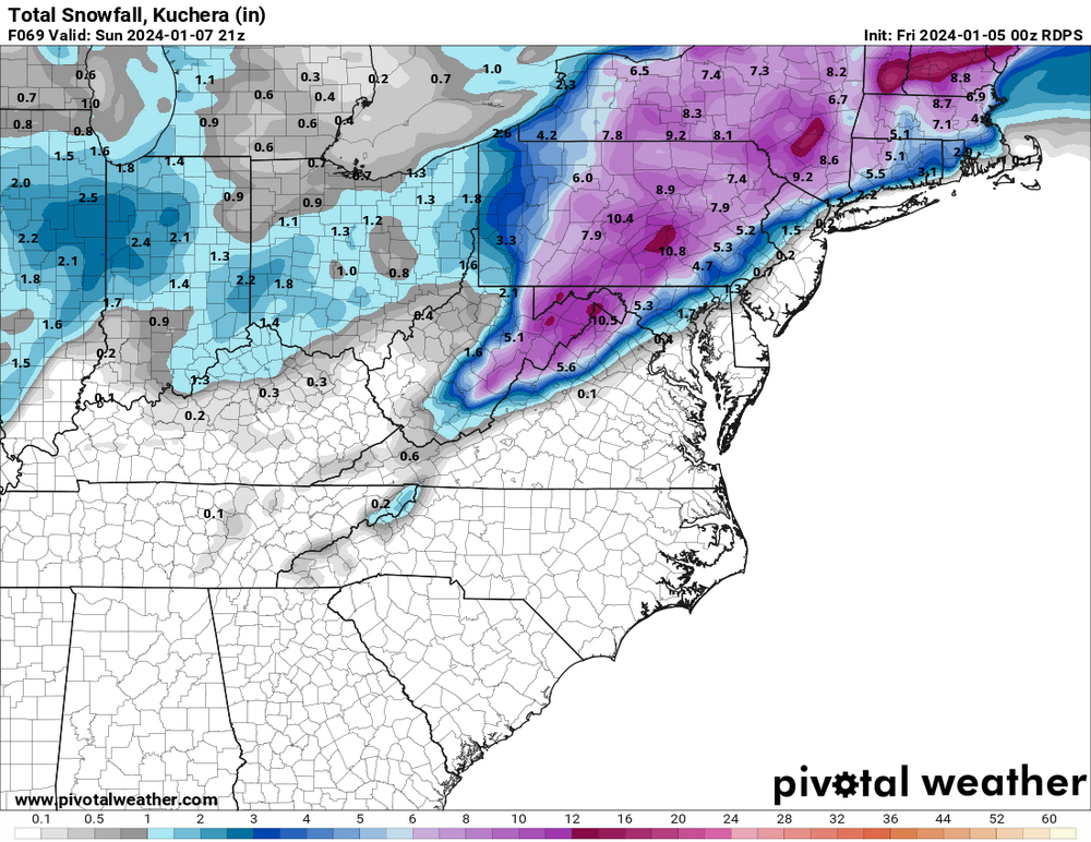
RGEM seems pretty reasonable to me. Not as cold as the NAM, not as blowtorchy as the FV3. Good hit for the LV and Poconos. It’s been pretty consistent showing something like this in the past few runs.
-
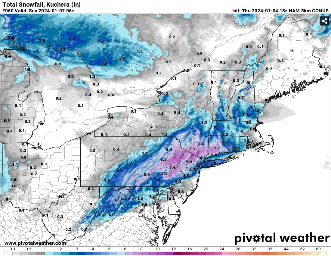
I freaking wish…I’m still liking 4-8” for us though. Made that call yesterday and see no reason to change it.
-
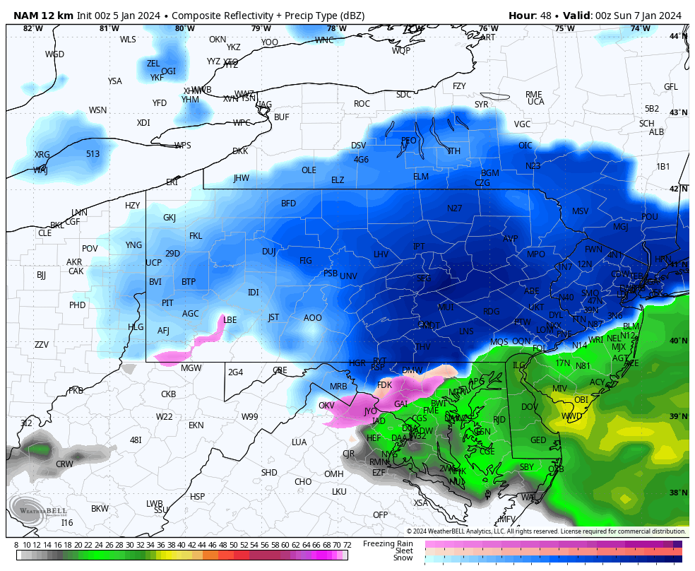
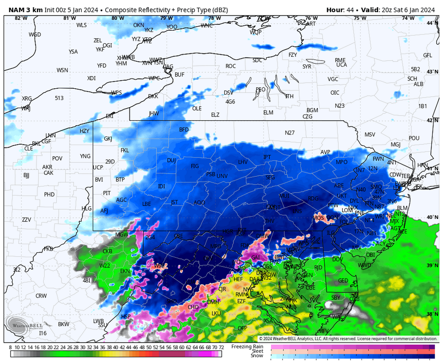
3km NAM is cold AF. Starts as snow almost down to Dover!
-
0z NAM with an absolute crush job for Philly on north. We have officially been NAM’d.

-
This reminds me so much of December 2020. Front end thump, then a light mix, then a deform band crashing through. I got 8" in that and I don't think I'll quite get there this time around, but I'm seeing a lot of similarities in the evolution of the storm.
-
3km NAM isn't half bad either. This is from the front end thump alone. Deform band hasn't formed yet.

-
NAM crushes the Lehigh Valley on east with that deform band. Extra 3-6" for I-78 east of Reading.
-
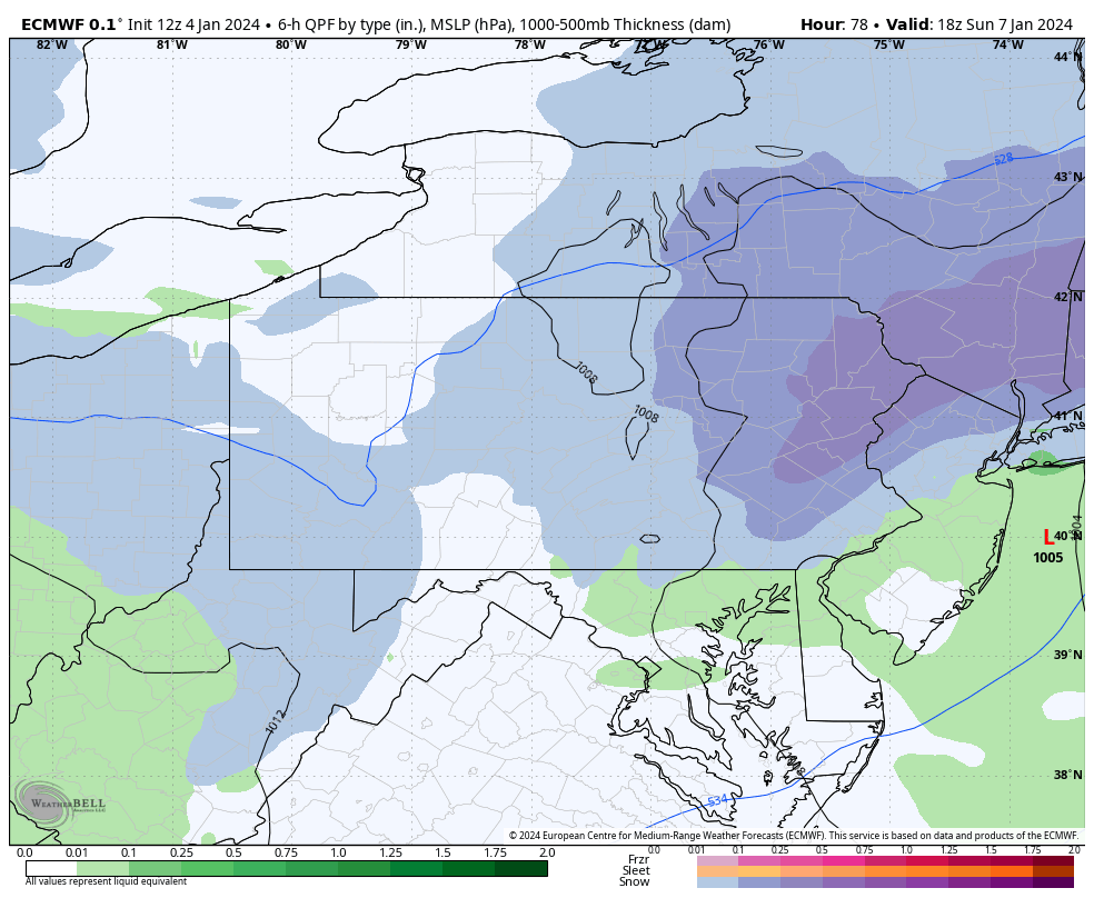
NAM is...interesting, to say the least. Much colder for Philly but very dry N&W.
-
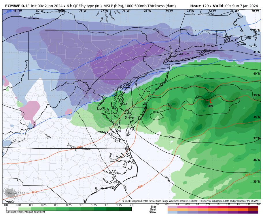
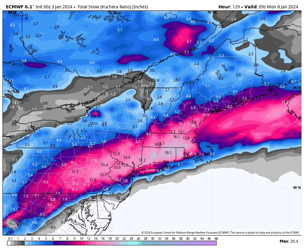
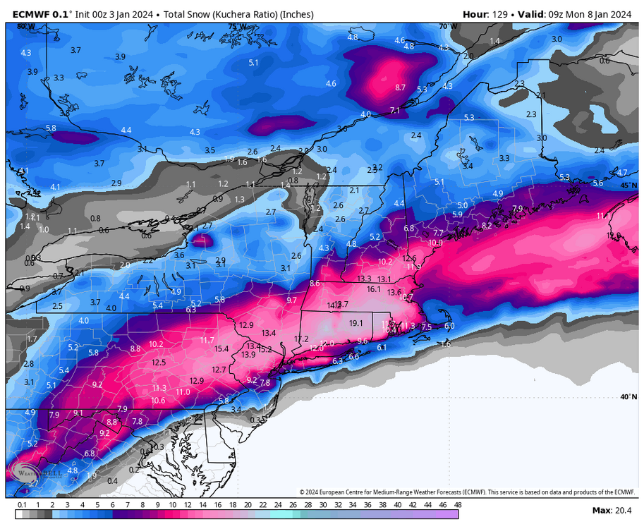
Euro has a really nice deform band Sunday morning northwest of I-95.
-
Meh, I’m calling BS on the GFS. I do think the trailing vort gives us some light snow but I just can’t see a huge deform band forming like that in our area.
-
I see so many people canceling this storm for the Philly burbs even into the Lehigh Valley, presumably because of that one warm Euro run last night. The Euro got colder at 6z and the only other model torching is the GFS, which is absolutely terrible at handling thermals. I’m still seeing a pretty snowy event even down to northern Bucks and Montgomery counties. The front end thump in these events often overperforms and dynamic cooling keeps things cooler. Will N&W areas mix? Maybe, but it probably won’t happen until the bulk of the precip exits. if you’re in or near Philly, then yes, there’s reason to be pessimistic. But I’m just not feeling like that for more northern areas.
-
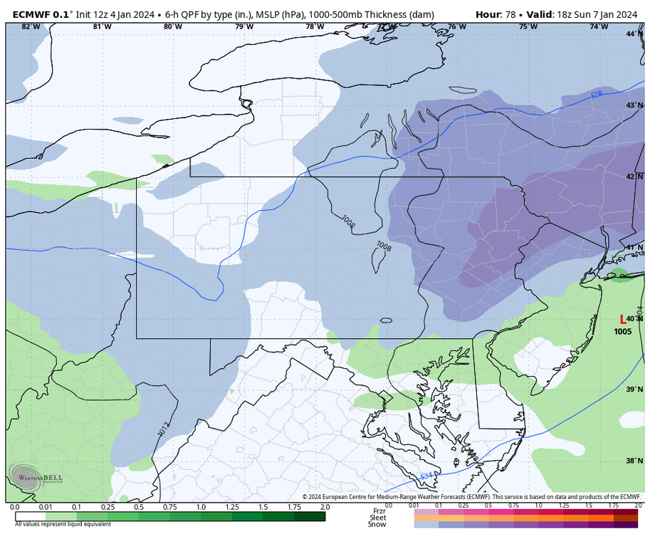
Euro is ugly for pretty much everyone. Quick front end thump quickly turns to sleet and rain as the mid levels torch. Gross.
-
If you're south of Philly don't look at the 0z runs...pretty ugly. The turnpike and 10-20 miles in either direction are hanging on but it's borderline there. Lehigh Valley and Poconos still look to be in a good spot.
-
The long range NAM will either show the most weenie outcome possible or something that’s ridiculously different from all the other models. Never fails.
-
Made my first call on my page…4-8” for the Lehigh Valley. That mix line does concern me a bit but I think we avoid it.
-
Don’t look now but the Canadian has gotten much colder for Tuesday. Significant event north of I-78.
-
Euro is weenie paradise for the I-78 corridor!
-
Very good 0z suite for the entire subforum. Except maybe the Jersey shore. GFS seems lost and even if it verifies it’s still not bad.
-
Wildly different evolution than any other run. Basically says F the primary low and kills it long before it gets to our latitude. Love the final product but I’m not sure I buy it.
-
Not a good trend for Philly and the immediate suburbs. Lehigh Valley on north still looks decent.
-
E PA/NJ/DE Winter 2023-2024 OBS/Discussion
LVblizzard replied to The Iceman's topic in Philadelphia Region
Oh man…tonight’s Euro is beautiful!