LVblizzard
-
Posts
4,433 -
Joined
-
Last visited
Content Type
Profiles
Blogs
Forums
American Weather
Media Demo
Store
Gallery
Everything posted by LVblizzard
-
Snowfall NYC subforum Jan 6 and OBS if needed
LVblizzard replied to wdrag's topic in New York City Metro
21z SREF mean is waaaaayyyyy north. Looks like the ICON. -
18z GFS with another jump north. 6-10” event up to the Lehigh Valley.
-
Snowfall NYC subforum Jan 6 and OBS if needed
LVblizzard replied to wdrag's topic in New York City Metro
I wouldn’t say *way* north but it is a pretty decent sized jump. -
6-12” from Wilmington all the way up to Scranton. Beautiful run! Now if only the other models could follow suit.
-
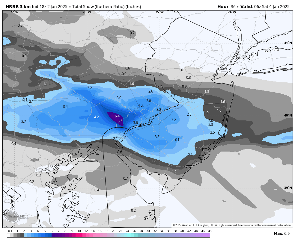
3km NAM isn’t as ambitious as the HRRR but it still paints a wide swath of ground whitening snow throughout SE PA.
-
Jackpot of half a foot in Chesco. This would be quite the surprise event.

-
GFS and Canadian look great. This is a warning level event for all of us with another 40-50 mile tick north. Which I think is fairly likely given how these systems usually trend.
-
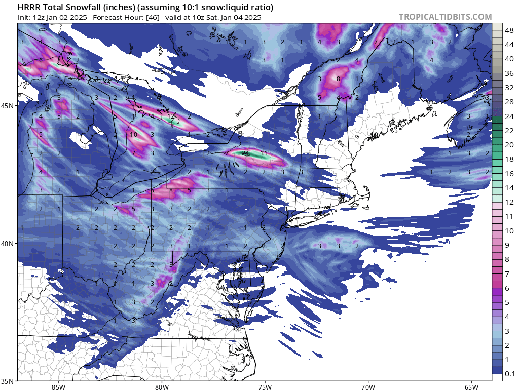
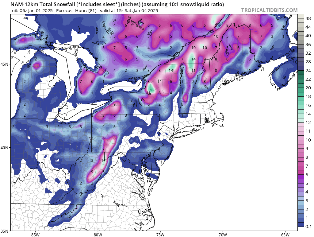
FWIW the 12z NAM at 84 seems in line with most of the other models. Maybe a little more amped.
-
12z HRRR gives us 1-3” tomorrow. Is it on to something? I’m inclined to say no, but we’ve seen these surprise setups produce before.
-
Euro ticked south a little. Still 3-6” for most of us.
-
These SWFE type storms trend north more often than not. I think plowable snow gets up to I-78 or I-80 in the end.
-
This is interesting. 6z NAM has a thin stripe of 1-3” in the Philly area on Friday.

-
Seeing good trends in the 0z models for the two storm threats next week. Hopefully we can get at least one of them.
-
Not getting any of the crazy wind or hail to the south but there is some lightning and thunder here. Crazy for New Year’s Eve!
-
Both threats are very much alive and well despite the surface output not looking great on a lot of the models. A lot of things would have to go wrong for us to not see anything.
-
12z models look like hot garbage at the surface but I’ll gamble with this H5 look any day.
-
Models are starting to key in on 1/6-1/7 rather than 1/9-1/10. Tonight’s Euro has a 986 low off the Delmarva throwing back 6-12” of snow into the area. The second threat isn’t dead yet but it needs a lot more things to go right to make it happen.
-
0z Euro is a flat out NUKE for this entire subforum!
-
Some really thick fog in and around Allentown tonight. Visibility down to 1/4 mile in spots. That GFS is very intriguing. Meanwhile the Canadian looks like it would focus on the second piece of energy around 1/9-1/11. Tonight’s Euro should be fun!
-
Snowpack has dwindled down to just a little bit of white in less than half the yard. I’m just glad it stuck around for Christmas.
-
0z meso models looking juicier for Tuesday north of Philly. Lots of them showing over an inch in the Lehigh Valley now.
-
I wonder how much of this snowpack will stick around till Christmas. I like our odds of a white Christmas with temps not getting above freezing for the next 3 days and the low sun angle, plus the chance of a little bit more on Tuesday.
-
Not surprised, lots of people went to work or even went for a night out thinking there would be no more than an inch on the ground by now. Instead there’s 3” on untreated roads. I was out delivering food for over 3 hours tonight and I didn’t see a single plow.
-
Looks like around 3” out there. I had to stop DoorDash for the night because the roads were getting too slick for my FWD car. Probably another inch or two tonight. Love these overperformers!
-
Looks like about 1 1/2-2” in and around Allentown. Still coming down too. DoorDash and Uber Eats are an absolute gold mine tonight because of the snow, I don’t think I’ve ever worked a night quite this good.