LVblizzard
-
Posts
4,433 -
Joined
-
Last visited
Content Type
Profiles
Blogs
Forums
American Weather
Media Demo
Store
Gallery
Everything posted by LVblizzard
-
January 3, 2025 Light Snow Event Observations
LVblizzard replied to ChescoWx's topic in Philadelphia Region
Dusting on the grass in Allentown. Steady snow has stopped but some flurries remain. -
1/6 snowstorm - nuisance event or something bigger?
LVblizzard replied to LVblizzard's topic in Philadelphia Region
Ends up being a little better but the MA forum still wins. -
Looks like a…uh, never mind.
-
1/6 snowstorm - nuisance event or something bigger?
LVblizzard replied to LVblizzard's topic in Philadelphia Region
Not sure if we’re about to fully get NAM’d or not but this run should be better than 12z. -
January 3, 2025 Light Snow Event Observations
LVblizzard replied to ChescoWx's topic in Philadelphia Region
This is the kind of event where I REALLY wish we had a radar near I-81 in the coal region. -
1/6 snowstorm - nuisance event or something bigger?
LVblizzard replied to LVblizzard's topic in Philadelphia Region
There’s also some confluence we have to deal with in the upper Midwest. Although that could be related to that lobe over Maine. -
January 3, 2025 Light Snow Event Observations
LVblizzard replied to ChescoWx's topic in Philadelphia Region
Those squalls in central PA look like they mean business. Hoping they hold together so we can get an inch or so. -
January 3, 2025 Light Snow Event Observations
LVblizzard replied to ChescoWx's topic in Philadelphia Region
Light snow has started in Allentown. Not sticking yet. -
Snowfall NYC subforum Jan 6 and OBS if needed
LVblizzard replied to wdrag's topic in New York City Metro
For what it’s worth (probably not much) the 15z SREF bumped north a bit. -
Radar is blossoming in central PA. Looks like it’s headed for the Philly burbs.
-
1/6 snowstorm - nuisance event or something bigger?
LVblizzard replied to LVblizzard's topic in Philadelphia Region
I would be very surprised if this storm trended down to just flurries and snow showers for us. In the Poconos, sure, but I’m confident accumulating snow will get to the Lehigh Valley. -
1/6 snowstorm - nuisance event or something bigger?
LVblizzard replied to LVblizzard's topic in Philadelphia Region
It’s called the crazy uncle for a reason. As much as it sucks it’s still better than the abomination it showed last night. -
1/6 snowstorm - nuisance event or something bigger?
LVblizzard replied to LVblizzard's topic in Philadelphia Region
GFS gives SE PA weenies hope again. Warning level snow up to Quakertown. -
1/6 snowstorm - nuisance event or something bigger?
LVblizzard replied to LVblizzard's topic in Philadelphia Region
12z models so far (NAM, RGEM, ICON) aren’t horrible for us. They all get accumulating snow into pretty much the entire Mt. Holly CWA, except maybe Sussex County NJ. But another tick south and I will start to get very worried. -
1/6 snowstorm - nuisance event or something bigger?
LVblizzard replied to LVblizzard's topic in Philadelphia Region
December was halfway decent so I wouldn’t consider us “snow starved.” But yes this storm is a really annoying one. -
Snowfall NYC subforum Jan 6 and OBS if needed
LVblizzard replied to wdrag's topic in New York City Metro
It’s the hope that kills you… -
1/6 snowstorm - nuisance event or something bigger?
LVblizzard replied to LVblizzard's topic in Philadelphia Region
12z NAM comes in line with the model consensus. Heavy snow stays south of Philly and I-80 on north gets nada. -
Snowfall NYC subforum Jan 6 and OBS if needed
LVblizzard replied to wdrag's topic in New York City Metro
With that new lobe of confluence showing up and pressing down into Quebec and Maine, we need this storm to buck the trend of slowing down and speed up again. If it’s too slow then that lobe comes crashing in and squashes the whole thing towards DC. -
1/6 snowstorm - nuisance event or something bigger?
LVblizzard replied to LVblizzard's topic in Philadelphia Region
Happened somewhat in Jan. 2016 too. 4-5 days out a lot of the models started to shift south and some even missed the Philly area. Then 2-3 days out the slow north trend began again and it ended up being a historic storm for all of us. -
1/6 snowstorm - nuisance event or something bigger?
LVblizzard replied to LVblizzard's topic in Philadelphia Region
Euro starts off fine but ends up positively tilting the trough as it approaches the Mid-Atlantic, as opposed to the GFS which amps it up and keeps it closed off. Pretty ugly run. -
Snowfall NYC subforum Jan 6 and OBS if needed
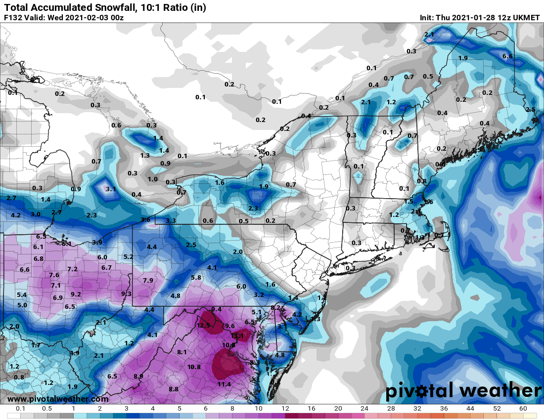
LVblizzard replied to wdrag's topic in New York City Metro
I’ve seen the UKMET do this before. In February 2021 it showed snow completely missing eastern PA 4 days out. I ended up getting 2 1/2 feet. Edit: found it lol
-
Started a thread for this one. If this storm trends back south towards suppression you guys can blame me.
-
1/6 snowstorm - nuisance event or something bigger?
LVblizzard posted a topic in Philadelphia Region
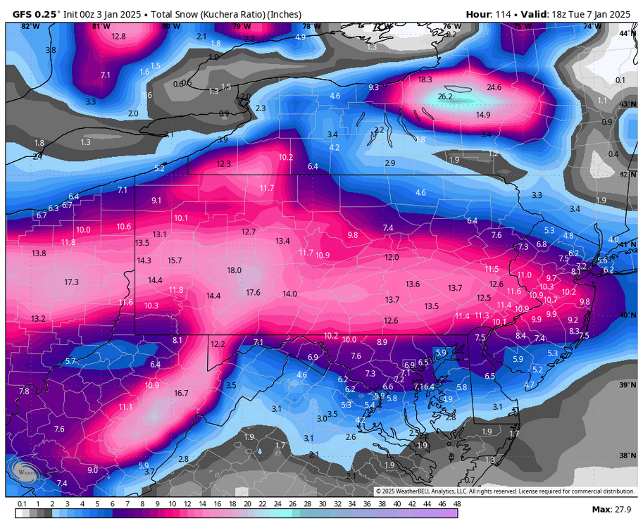
It now appears pretty certain that it will snow on Monday. So I don’t think a thread can curse us. The question is, how much? Some models, like the Canadian, keep the heavy snow to our south in Baltimore and DC. While the GFS has a MECS for all of us. It’ll be an interesting weekend of tracking, hopefully we can all get in on the fun with this one. -
The GFS turns this into a fairly long duration storm as snow continues with the passage of the vort, as opposed to previous runs where most of it was the front end WAA thump. As a result we get a major snowstorm.
-
Ummm…holy GFS. Wow. This is a crazy good run for all of us.