nwohweather
-
Posts
3,694 -
Joined
-
Last visited
Content Type
Profiles
Blogs
Forums
American Weather
Media Demo
Store
Gallery
Everything posted by nwohweather
-
Bad idea in my opinion. It’s more simple to know there’s a Winter Weather Advisory than issuing headlines
-
Largest dense fog advisory in US history?
-

Did Someone Say Clipper(Hybrid)!?! 1/18-1/19
nwohweather replied to Frog Town's topic in Lakes/Ohio Valley
Might be time to change the avatar from the Heat Miser. Strong clippers and frozen ponds, Winter has actually arrived! -
Winter 2023/24 Short Range Discussion
nwohweather replied to Chicago Storm's topic in Lakes/Ohio Valley
I almost think these two waves are being underplayed for the Toledo area. I think 2-4" with the energy rotating around the ULL tomorrow is a solid bet along the turnpike followed by 3-5" with such high snow ratios and a relatively strong clipper. May be best to put an advisory in place as 4-8" of fine powder over the course of 48 hours is going to be relatively impactful, especially from a blowing & drifting perspective -
Glad to see I had good instincts haha! 3 was good timing, it definitely was wild to see the weird cold air solution shown by the models actually play out in real life.
-
Accumulations definitely at 3” here and climbing. Such a slushy snow
-
Where are you? I'm by the river in P-Burg/Waterville
-
Very heavy here as well. A bit more wind driven as well. That's brutal. Meanwhile off to the east it's pouring snow
-
Rippage
-
Man am I a genius or what?
-
NWS Cleveland needs to get WWA's up ASAP. The snow is far more entrenched along the lines of what the GFS showed than what they predicted. Tough call, but I think 3-4" is capable. It's definitely extremely wet, heavy snow
-
I think 2-4" for NW Ohio looks pretty reasonable... At 119 PM EST, radar indicated wet snow moving north into the Toledo metro area. HAZARDS INCLUDE... Visibility dropping to less than three quarters of a mile... Up to 2 inches of quick snow accumulation through 5 PM... Locations impacted include... Toledo, Swanton, Perrysburg, Oregon, Sylvania, Rossford, Waterville, Northwood, Whitehouse, Genoa, Holland, Maumee, Ottawa Hills, Walbridge, Millbury, Haskins, Grand Rapids, Tontogany, Clay Center, and Berkey. Heavy, wet snow at the moment with visibilities below a quarter of a mile. I think that 2" amount will be exceeded in spots, especially west of Toledo
-
Absolutely ripping snow at my house SW of Toledo. Radar returns of rain are inaccurate
-
Yes
-
Lightning just caught on the weather channel live! That was awesome
-
Ice fog levels of cold
-
This keeps trending towards something more substantial for Toledo
-
I’m gonna go with 2-4” for everywhere west of I-75 with 1-2” east of it here in Toledo. I can’t imagine how bad conditions will be in the heart of this storm, absolutely paralyzing to get those winds with this level of snow
-
Should’ve changed into January gale or white hurricane like the old newspaper articles
-
Unreal runs on the GFS... Almost 24 hours out and it's showing 0" essentially on the Euro & 4-6" on the GFS for Toledo. This is insane
-
What in the world...

-
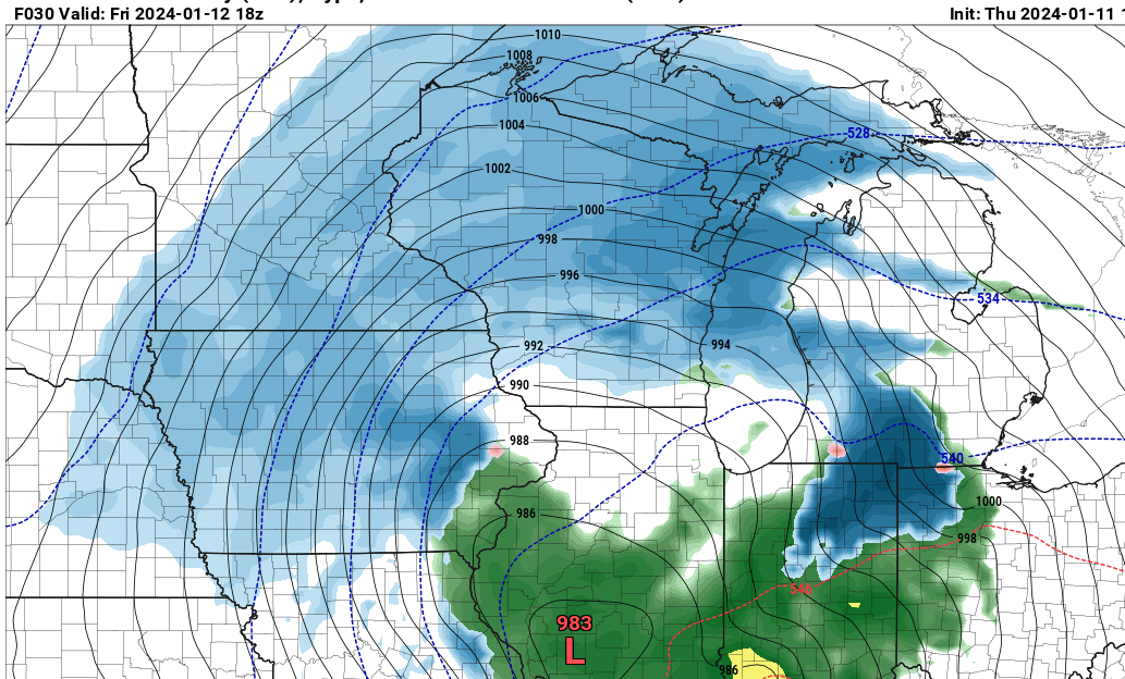
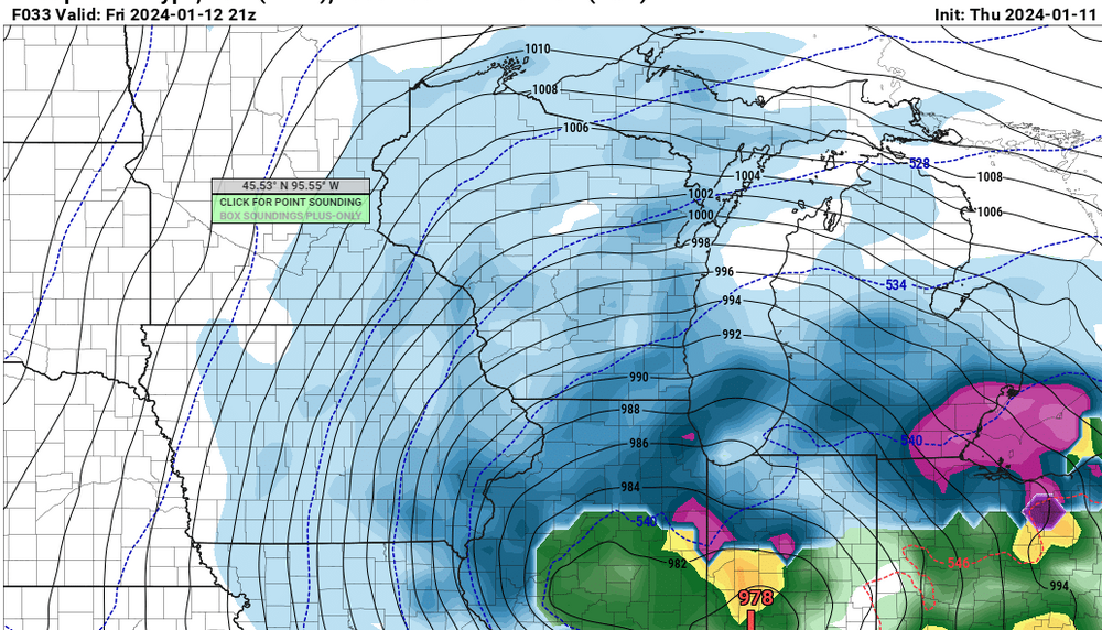
Pretty good agreement on the models here today. Can't say it any different, that's a historic blizzard for this weekend.
-
Winter '23-'24 Piss and Moan/Banter Thread
nwohweather replied to IWXwx's topic in Lakes/Ohio Valley
Tomorrow evening is when the picture becomes much clearer. Sampling occurs, the current system moves out and the NAM comes into play. Patience folks -
Barometer at home officially at 28.90. Can’t say I’ve seen it this low much in my life
-
So often you see the heaviest snows trend more towards the IN border counties west of I-75. We will see here but with mixing it wouldn’t shock me to see Toledo proper shafted a bit