nwohweather
-
Posts
3,694 -
Joined
-
Last visited
Content Type
Profiles
Blogs
Forums
American Weather
Media Demo
Store
Gallery
Everything posted by nwohweather
-

-
Definitely deserving of a moderate risk today. Hot take, the NWS being in Norman, OK comes with biases
-
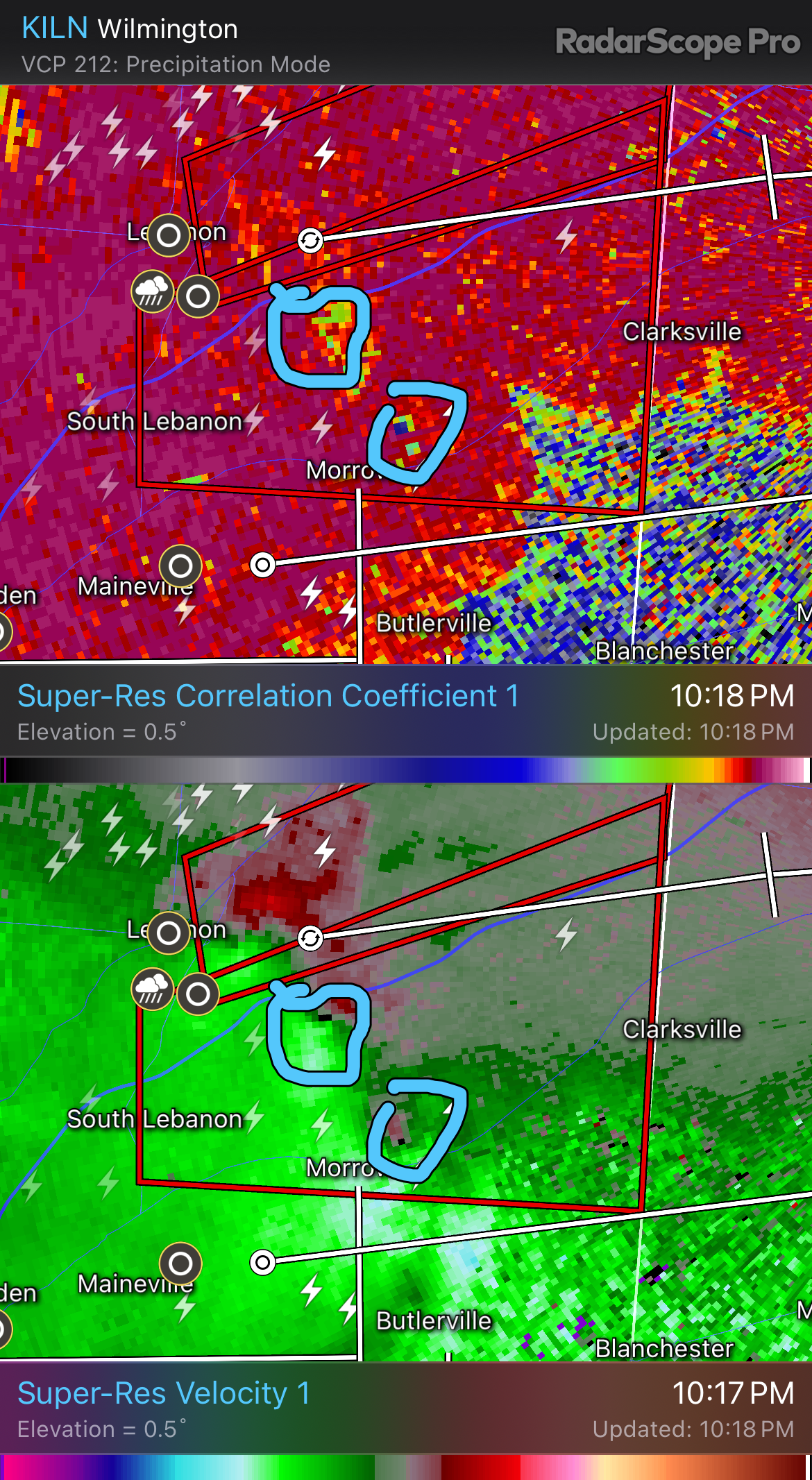
What’s your thoughts on the Paulding county cell? Some better shear and helicity off to the east may help it tighten up fully IMO
-
It looks like the Ohio Turnpike is sort of the line. Decent amount of CIN in place at the moment in the mid layers. I think the cell around Paulding, OH could stay tornadic until around Bowling Green
-
STP’s are very high in NW Ohio at the moment. That Indiana cell could explode as it heads east. Only caveat is that the air seems drier in NW Ohio
-
East wind off the lake may put a lid on this for Toledo proper. Areas to the south though… That Ft Wayne storm looks legit
-
Fremont, IN just was hit by a large tornado
-
Headed to Bowling Green, Ohio to chase. Instability isn’t even high where those large tornadoes are at the moment either SPC should consider a MDT as well
-
Man the atmosphere around Findlay is absolutely juiced at the moment. Serious ingredients in play
-

Severe Weather 5-6 through 5-9-24
nwohweather replied to cheese007's topic in Central/Western States
I'm glad someone brought this up. I can't hate on the High risk because it was a very small area that had it. Moderate would have been fine but we did get a truly violent tornado that was long tracked. -
If the lunchtime line can put a nice boundary down, it may get pretty dicey this evening. Van Wert to Findlay would be an outstanding place from a chase perspective to scout out.
-
Severe Weather 5-6 through 5-9-24
nwohweather replied to cheese007's topic in Central/Western States
Idk if anyone buys into the “nudge theory” but that’s a textbook display north of Tulsa. Has to be a huge twister there -
Agreed. NW Ohio/rural SE Michigan and NE Indiana is very similar to Oklahoma, especially NW Ohio
-
Severe Weather 5-6 through 5-9-24
nwohweather replied to cheese007's topic in Central/Western States
Still some CIN in the mid levels. What an impressive clash of air masses, you have a dryline featuring dews in the 20's running into a near tropical airmass with dews into the 70's. The LCL's are absolutely ground scraping, especially into East OK/KS at the moment. This evening certainly has a chance to be historic -
Severe Weather 5-6 through 5-9-24
nwohweather replied to cheese007's topic in Central/Western States
Impressed at the strength of the jet max on the latest models. I don't blame the SPC going with a High risk here, any discrete cells should be able to cover a lot of ground today and put down some prolific tornadoes. With the LCL's projected to be where they are, I wouldn't be shocked to see some nice videos of wedge twisters today. Can't sleep on the damaging wind risk as well, that's going to be a very potent line once everything congeals -
Severe Weather 4-30-24 through 5-2-24
nwohweather replied to cstrunk's topic in Central/Western States
Maybe one of the more reckless, but no. IMO the Phil Campbell, AL tornado takes the cake for me -
Severe Weather 4-30-24 through 5-2-24
nwohweather replied to cstrunk's topic in Central/Western States
Sheesh that cell is trying so hard in Topeka -
Severe Weather 4-30-24 through 5-2-24
nwohweather replied to cstrunk's topic in Central/Western States
The environment looks dangerous around OKC. Unreal it’s under a MARGINAL risk, showing no inhibition with extremely high instability and much better LCLs -
Severe Weather 4-30-24 through 5-2-24
nwohweather replied to cstrunk's topic in Central/Western States
If that thing tightens up in the next 10 minutes then we’ve got a situation here. Quite a bit of instability and helicity to work with. Condensation level is a little high north of OK though -
Not a bad storm reports day at all, definitely warranted the slight risk. Shocked to see some of the damage reports on US-127, it did not seem like the line was that strong at the time it went through there
-
Not much of an event here in the Toledo area. Looks like the LCL put a bit of a lid on things, instability and shear weren't enough to drop anything truly severe
-
NW Ohio has a much better environment. LCL's likely need to come down a few hundred meters though
-
Might just need a little more humidity for this to really get going. The atmosphere is solid at the moment, I'm shocked nothing is really taking off
-
Tornado Watch going up shortly in west Ohio
-
Little rain overnight is all that's left over. To be honest, I'm not sure why they aren't going ENH, the atmosphere is going to be absolutely primed across the region today.