nwohweather
-
Posts
3,733 -
Joined
-
Last visited
Content Type
Profiles
Blogs
Forums
American Weather
Media Demo
Store
Gallery
Everything posted by nwohweather
-
Wow what a long track storm this has been. Still showing a major tornado as it moves into Georgia. Has to be approaching 150 miles worth of warning length
-
Meh I'm not totally sold here. SRH is not what it should be for this
-
Look at that debris ball
-
Verbatim that cell is in an area of 66 knots of shear, SRH of 325 & a LCL of 491 with decent instability
-
Wow this thing is going wreck Hoover. Good Lord
-
Too much convection firing up on that main cell's inflow. You almost wonder if the insane amount of forcing aloft clutters the playing field today
-
What a monster of a storm and at Noon!?
-
It’s a general rule of thumb in my opinion. I think back to my Great Lakes days and the June 2010 outbreak where you had a deepening low spawn one violent tornado and multiple EF-2’s through NW Ohio/SE Michigan around the midnight hour. In fact many of the better tornado outbreaks I’ve lived through were lows going through significant intensification bringing in ample winds aloft and moisture. Also let’s not forget we’re talking about an expected up to 3500 j/kg of energy and SRH’s in the ballpark of 500. That is simply insane
-
People comparing this to last week need to remember that the low was much weaker than this bad boy. We’ve got a rapidly deepening low expected to go below 990 MB. That is something that in my opinion was really lacking last week. Even here at home we’ve got dews into the mid 60s far from the low
-
Perfectly said forecast by the SPC. Sure previous convection could ruin it, if it does not then we're looking at a historic afternoon/evening
-
Jesus this looks like a more southerly positioned version of April 3rd, 1974 on the CAM's
-
Insane pattern we’re in here folks. After getting 33 tornadoes last week in one day (absolutely a High risk verified) we’re now looking at potentially another in the same spot? Wild
-
Deaths are way down though. Looking at the numbers last year this time I think that has a lot to do with current attitudes. In places like Michigan, New York, Illinois where deaths were in the hundreds daily last Spring really affected the populace quite a bit in how they view the virus. That never happened in the South which combined with political climate made this area so standoffish towards pandemic rules.
-
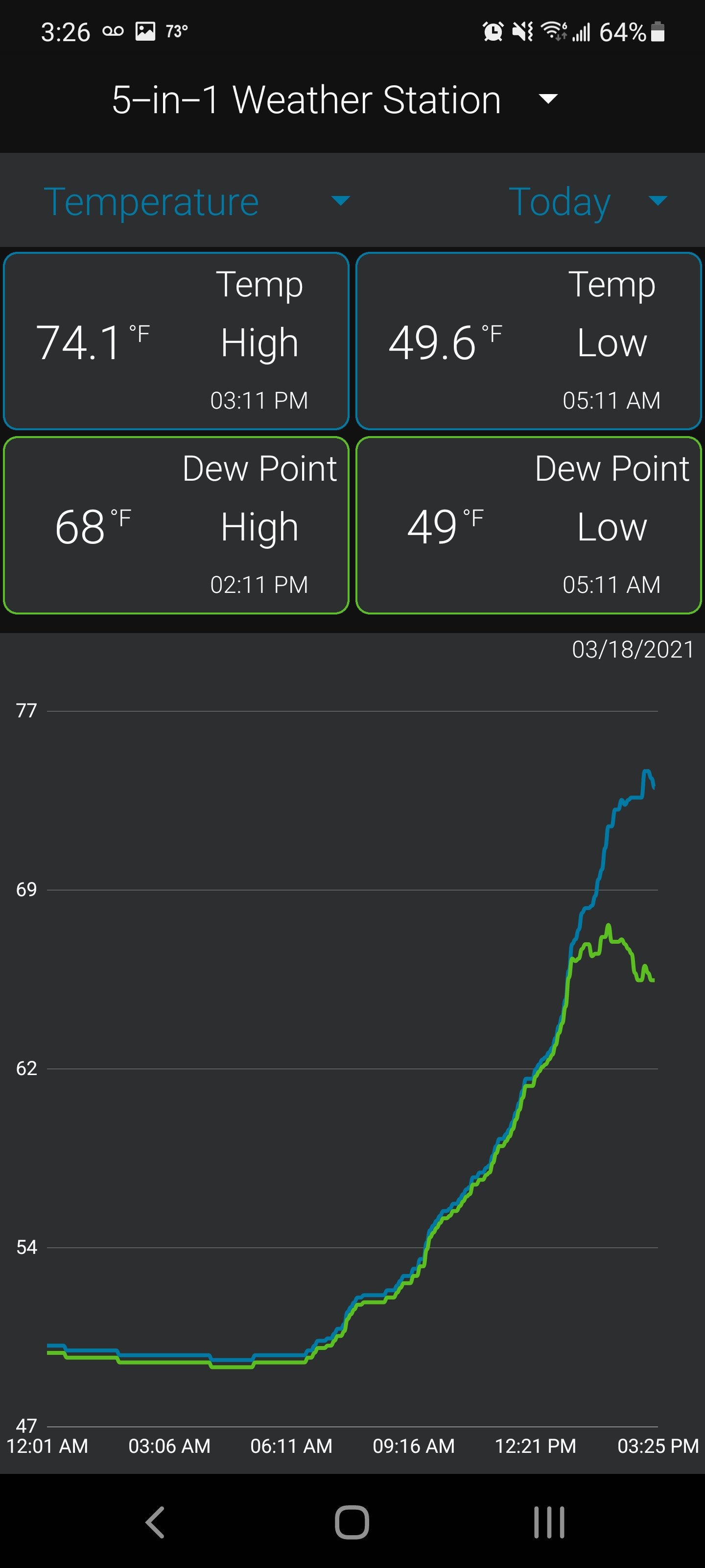
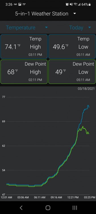
I'll be honest, I've been slightly stunned at the moisture/temps expected in this which gives me actually more confidence than what we had last week. We've had a fishing/camping trip planned for sometime out by Columbia, SC so to see mid to upper 80s this weekend shows the dynamic nature of this system. I know I am certainly a hobbyist in this field but the thing that gives me quite a bit of pause is the strength of the low shown on the Euro. Last week we were dealing with a system at 998 MB I believe at its strongest, while the Euro shows a rapidly deepening low for this week that may very well go sub-990. I'd say the vast majority of outbreaks I've dealt with in the past had this very feature, a strong deepening low sparking off overachieving cells that spawn violent tornadoes.
-
Yeah I’m over this chilly weather. It is not helping the golf game at all
-
Got the fireplace rocking today
-
Man this thread is woke. I for one am disgusted that the 1918 epidemic is referred to as the “Spanish Flu”. What a disgusting comment to those in Spain, how will they get by with such an offense
-
Definitely a major tornado out over the ocean at the moment...
-
Agreed but it costs $10 Million for a new one, and $500K a year to maintain. Very expensive technology for sure
-
Right haha a quick step outside and you can visually see the LLJ absolutely screaming here
-
Charlotte cell moving into better instability and SRH as it goes east. To be honest it may drop in the city as I'm getting 80 mph winds already per RadarScope in the couplet
-
Nice updraft on the cell just west of Charlotte. If that thing tightens up could see a potential tornado in a heavily populated area
-
Nice little CU field back in GA here, sun is now out here as well
-
Terrible take in my opinion. Massive clearing is unfolding across GA/SC/NC with CAPE surging. We have 60-70 knots of bulk shear, SRH at 200-400 to boot. It would not shock me at all if the atmosphere recovers fully to get 1-2 long track tornadoes this evening
-
Gonna be interesting here folks. So much shear and helicity in the air, once we get this crapvection out of here that line is for sure going to spark of some storms all across SC/NC