nwohweather
-
Posts
3,733 -
Joined
-
Last visited
Content Type
Profiles
Blogs
Forums
American Weather
Media Demo
Store
Gallery
Everything posted by nwohweather
-
Two large tornadoes that could come into play soon for Owensboro and Clarksville. While the big one may be on its last legs, these two definitely are not. Instability is still there and SRH is off the charts now as the pressure continues to fall with this deepening low. Just an absurd environment
-
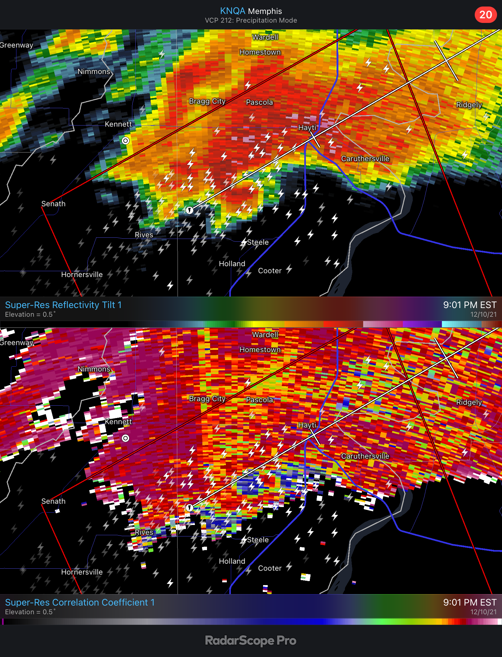
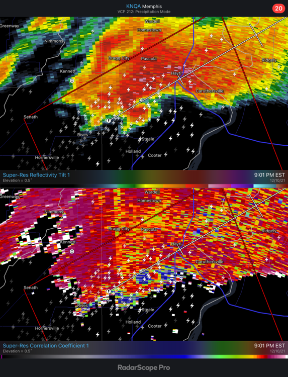
I don’t think this tornado has weakened as much as folks think. It’s in a bit of a radar hole and still posting a solid couplet
-
Was going to post this. Louisville is going to be under the gun around 1:30 Eastern and the SPC believes if anything that the atmosphere is only going to ripen ahead of this
-
My thoughts exactly. Regardless of if there was some lift at all, we’re looking at a damage path of 150-200 miles. The emergency response is going to have to be incredible here for so many affected. Hopefully they can get Paducah’s radar back, there are still some strong supercells off to the west
-
If I’m not mistaken, this is probably the longest track tornado ever at this point
-
Probably need to send the National Guard in ASAP. Another town wiped out there in Princeton…
-
What’s horrifying is that this low is deepening and SRH levels across the region are rising considerably. LCL by and large is only 600 meters as well. In all honesty, this is the best environment of the evening currently
-
I’ve never seen this much debris falling out on a radar. Until that main line catches up, this thing is going to continue to be violent. Absolutely amazing how long this has gone unimpeded by neighboring storms
-
I feel like I’m watching Greensburg all over again
-
Worse thing I’ve seen in a long time. That town just got wiped out
-
KY/IN storms clearly battling CIN at the moment. Not a very robust look outside of the long tracker that just entered the state
-
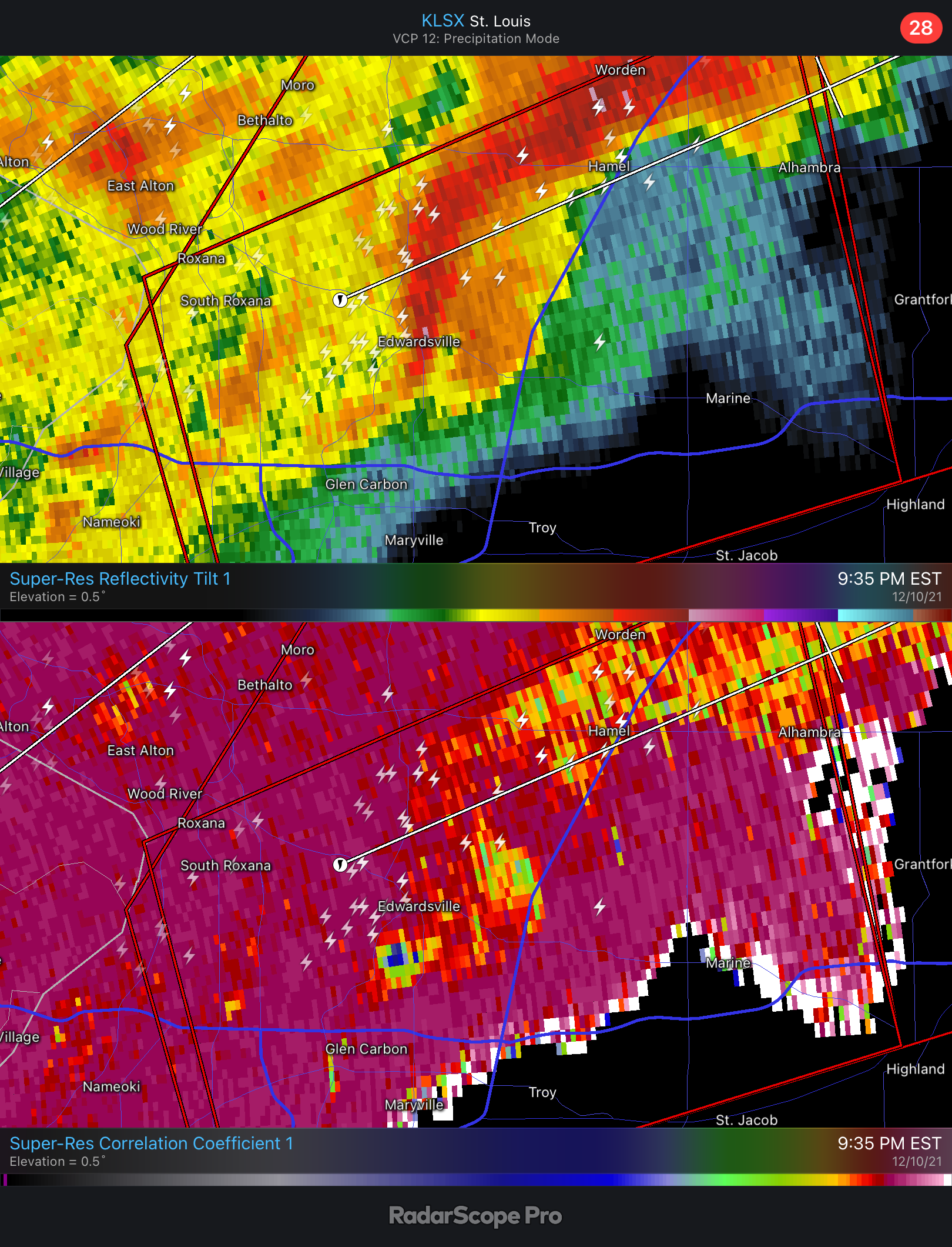
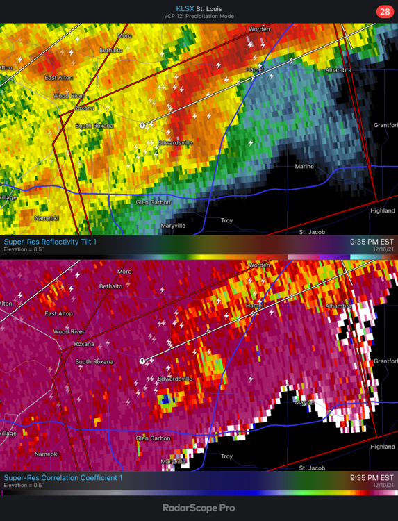
Not the most impressive reflectivity considering the CC drop
-
Some CIN ahead in Kentucky could be the dagger
-
That thing is incredibly violent at the moment. And the environment is just perfect. SPC has a discussion about it
-
And it’s in a little bit of a radar hole as well. That structure looks as good as ever
-
Just wow at the scope of this outbreak currently. Talk about a big dog cell north of Memphis
-
And to think this is the slow one. I wouldn’t be shocked tonight to see storm motions at 60+
-
Nail on the head, dews are approaching 70° in Memphis & Jackson already. Once that cap breaks tonight, holy smokes. So many ingredients in place for long track twisters tonight
-
Seems like more of a linear event but we’ll see. That jet is going to absolutely be hauling the mail tomorrow night though
-
Definitely some severe chances on the horizon
-
Damn, I didn't know my chances could get any lower to be honest here...
-
Man a week straight of 70°/50° incoming? Sweet Jesus that's perfection
-

Could it be? November 13-15 Potential Snow
nwohweather replied to Hoosier's topic in Lakes/Ohio Valley
Definitely looks like a legit slug of cold across the Eastern US next week. 540 line dropping all the way to the TN/NC southern borders, and definite chances for lows in the teens west of Lake Michigan next week. Winter is definitely coming -
Have a week of meetings next Monday across our Michigan operations. It literally always snows when I visit during the cold season so I expect to some flurries, especially when I’m in Muskegon for a couple of days
-
There's always that one maple that hangs on later than the others