nwohweather
-
Posts
3,733 -
Joined
-
Last visited
Content Type
Profiles
Blogs
Forums
American Weather
Media Demo
Store
Gallery
Everything posted by nwohweather
-
Honestly wouldn't shock me if this eventually is the track. Probably will be closer to Columbia but still it's not that far away
-
I'd feel really good if I were in Greenville, Winston-Salem & especially Asheville. Charlotte & Raleigh are going to have an absolute mess on their hands with the 3-5" of concrete that falls here. Regardless, I'd get groceries now because most of NC & VA is going to get shut down by this storm
-
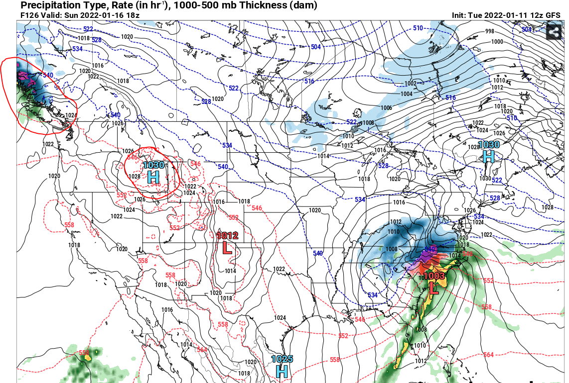
These model runs are pretty amazing, especially on the Euro. Honestly with that powerhouse high to the north I'm shocked it isn't going further south. Definitely a very strong storm to say the least, a 10 mb drop in 6 hours is some legit stuff. From 1005 mb over Birmingham to 978 when it's over CT shows just how dynamic this system is. I'd feel confident if I'm in Chattanooga, Greenville & Asheville, and somewhat worried in Charlotte & Raleigh. With the moisture transport & pressure gradient this has all the looks of a serious snow machine
-
If you compare the GFS & Euro the Eastern US is pretty similar, high pressure placement almost identical and only 4 MB difference. However the GFS is showing major difference to the west, the high over ID is considerably weaker on the GFS and it's bringing a low pressure into the Pac NW about 12 hours sooner. Just seems to be one of those solutions that until we get to sampling will produce some wild differences as there's so many pieces of energy throwing the models off. It's my opinion that the GFS is clearly not handling this well

-
One of the greatest spreads I’ve ever seen. GFS deepens into arguably a blizzard with a monster 12-18” swath meanwhile the Euro has a 1-3” special from Aiken to Wilmington. I will say I worry about how amped the GFS is throughout this storm, shows almost a foot of snow when this thing is back in Omaha & Des Moines. Euro is probably the more realistic solution at this time
-

Mid to Long Range Discussion ~ 2022
nwohweather replied to buckeyefan1's topic in Southeastern States
Nice!
-
Mid to Long Range Discussion ~ 2022
nwohweather replied to buckeyefan1's topic in Southeastern States
Speak for yourself lol still making tee times here. Next weekend looks very interesting, especially for the folks in VA. Still, I’d like to see a little more of a snowpack put down in the Midwest to firmly entrench that cold air in the Eastern US -
I will say those deep cold snaps were a treat for pond hockey & snowshoeing. Definitely would be okay with a Traverse City/Minneapolis type climate which is ironic coming from someone in Charleston but hey that’s what makes weather so cool right?
-
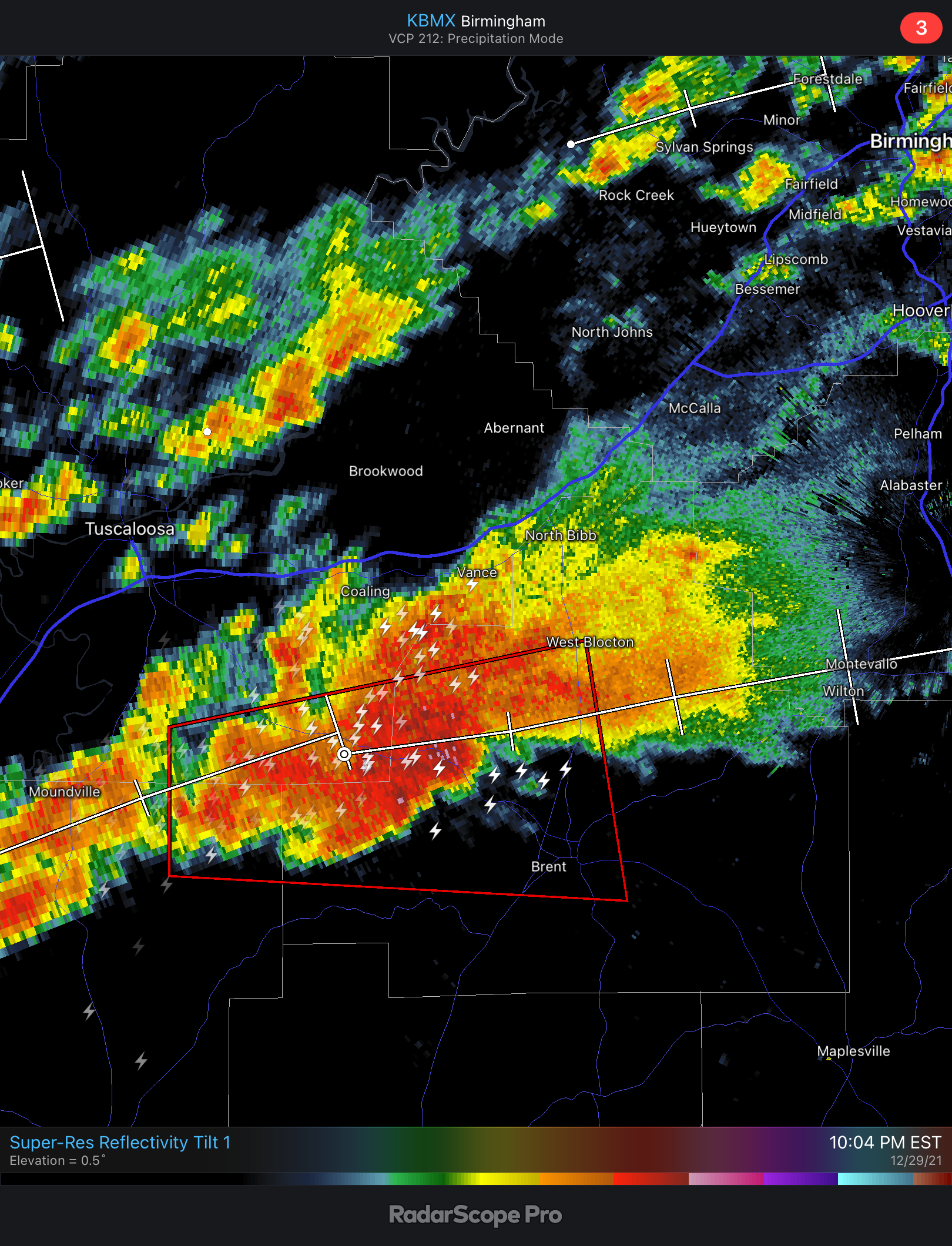
Might be a little bit of an event over in MS/AL today… URGENT - IMMEDIATE BROADCAST REQUESTED Tornado Watch Number 14 NWS Storm Prediction Center Norman OK 1045 AM CST Sun Jan 9 2022 The NWS Storm Prediction Center has issued a * Tornado Watch for portions of Southwest Alabama Southeast Mississippi * Effective this Sunday morning and evening from 1045 AM until 600 PM CST. * Primary threats include... A few tornadoes likely with a couple intense tornadoes possible Scattered damaging wind gusts to 70 mph likely Isolated large hail events to 1.5 inches in diameter possible SUMMARY...Thunderstorms are intensifying over southeast Mississippi, and other storms are likely to form farther east into southwest Alabama through the afternoon. Conditions appear favorable for a few supercell storms, capable of isolated tornadoes and/or damaging wind gusts.
-
My complaint is everyone expects a Traverse City winter. The last 15 years have totally spoiled snow fans with its deep cold and deeper snows
-
Just about. In Birmingham average highs in November are between 60-70 degrees
-
Orangeburg wouldn’t be a bad place to post up today
-
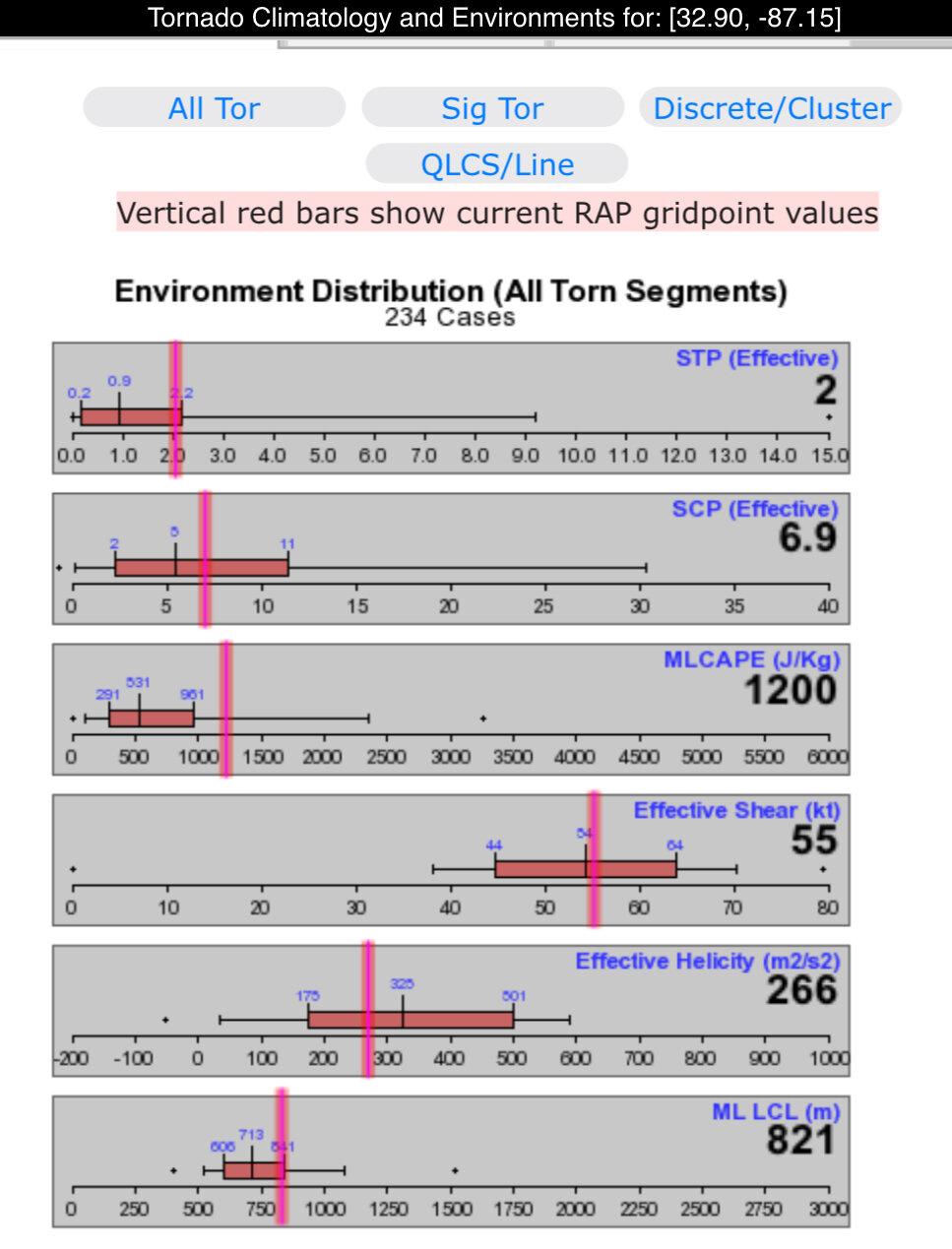
What a gorgeous low! The thing I love about weather is whatever goes up, must come down. After a week of April weather we go hard into the season with back to back lows. I think we’ll get some winds up to 40 mph in the Midlands and Lowcountry but other than that I’m not expecting much. It’s a shame soil temps are what they are, or else we could’ve had clipper like accums in North Alabama & Georgia. I will say though I expect some tornadoes today that definitely bear watching on the warm side of this. Not too much instability but just enough with a strong jet and tons of helicity. Definitely an October/November Midwest type threat today
-
It’s what the models have been showing for quite sometime. Widespread severe weather combined with a primary moisture feed from the Pacific is not an ideal combo. Too much dry air
-
Just flipped on the Winter Classic, holy smokes it’s -6° in Minny right now?! Some serious cold air behind this thing eh?
-
Absolutely not toss worthy. Hard wish casting by a pro right here
-
Tomorrows southern severe outbreak is going to play a huge role on the snowy side of things. Just too likely that intense convection is going to rob the backside of the storm of moisture, 3-5” except back towards the IA/MO/IL border is probably best bet.
-
Could get interesting for sure

-
On track to finish December with 19 of 31 days with highs in the 70’s here. Even with a few chilly days looks like our average high is going to be 69°, that’s 9° above average for December. Glad to see you’re getting a little winter weather in the region, gives me hope for some “Fall” weather
-
On track to finish December with 19 of 31 days with highs in the 70’s here. Even with a few chilly days looks like our average high is going to be 69°, that’s 9° above average for December. Glad to see you’re getting a little winter weather in the region, gives me hope for some “Fall” weather
-
Fall/Winter Banter - Football, Basketball, Snowball?
nwohweather replied to John1122's topic in Tennessee Valley
I figured it’d have to be warm up there as well. I’ve been routinely running my AC here in Charleston the last few weeks -
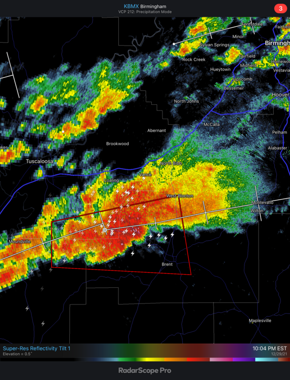
Lots of CIN really putting a lid on tonight. If it wasn’t for that, we’d have likely a significant outbreak tonight
-
Tons of shear aloft and decent SRH, but looks like some solid CIN is really putting the lid on this evening. Just nothing really taking off despite a Tornado Watch that is cautioning for even intense tornadoes. I’m just not seeing it here
-
Right lol? I certainly do. Today hasn’t been the most lively day though, just a couple notches in the line
-
That environment is gonna pop off at 3-4 Central here. I’d be real worried in N MS today, strong LLJ with little CIN and ample instability