nwohweather
-
Posts
3,733 -
Joined
-
Last visited
Content Type
Profiles
Blogs
Forums
American Weather
Media Demo
Store
Gallery
Everything posted by nwohweather
-
I suggest you read up on that storm. Drifts were up to 20’, winds gusted to 60 mph, barometric pressure bottomed out around 956 MB. No one really knows how much snow either because of the wind
-
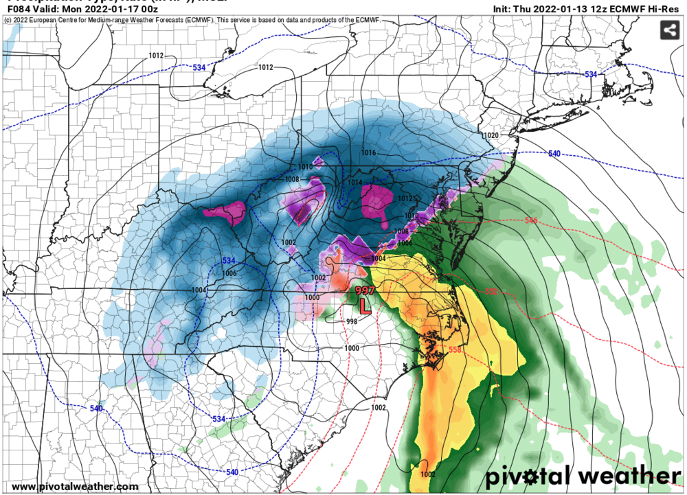
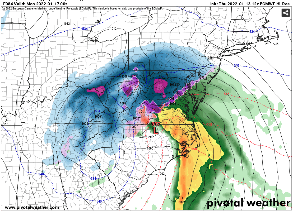
Amazing to see these model runs. If I’m not mistaken in 2009 we received a similar storm that was a 1’ of long drawn out snow. To see the Euro pumping out 15-25” across NW Ohio with isolated amounts of 30” is almost incomprehensible
-

Potential 1/28-1/30 2022 winter storm
nwohweather replied to Prismshine Productions's topic in Southeastern States
I said it before this week, that conveyor belt looked slightly over amped -
I need to schedule a work trip to Toledo ASAP
-
Potential 1/28-1/30 2022 winter storm
nwohweather replied to Prismshine Productions's topic in Southeastern States
I'd personally never want to see it. Growing up in Northern OH, anything over 10" was quite debilitating to the region and that was with a plethora of snowplows and houses having proper heating. Many down here don't and a storm of that size is going to have tons of cold on the backside of it that will linger for a few days at least. The infrastructure already cannot support the population surge, I cannot imagine what would happen if SC got something like that. To this storm, I'm interested to see how much convective feedback may be playing into it. Euro is bombing it to around 965 MB which would be on par with the Midwest Blizzard of 78 strength wise. I think the conveyor belts may be a little overamped which could be why it's so hell bent on dropping 2-4" when in reality 1-2" is probably more likely with isolated amounts of 3" -
If there’s one thing I miss, it’s pond hockey. Just an awesome time
-
Potential 1/28-1/30 2022 winter storm
nwohweather replied to Prismshine Productions's topic in Southeastern States
100%. It’s easy to love the GFS and it’s over amped solutions though -
Mid to Long Range Discussion ~ 2022
nwohweather replied to buckeyefan1's topic in Southeastern States
I have to say it’s quite something to go from basically April/May weather to true winter conditions -
Feel like I’m back in Ohio tonight. 20° with football on and cold Coors
-
Pretty cool to see the amount of snow up in NC. What a wacky year with back to back snowstorms through the South
-
January 20-22 “bring the mojo” winter storm threat
nwohweather replied to lilj4425's topic in Southeastern States
Just feels like a hard wish cast map. Hard to expect these results out of such a weak low -
January 20-22 “bring the mojo” winter storm threat
nwohweather replied to lilj4425's topic in Southeastern States
Definitely could see some accretion on Friday night here in Charleston, but it'll be so difficult with today's warm weather I think for things to get too dicey around here. If anything I think the "re-freeze" opportunities on Saturday night could create more challenges than the actual freezing rain event itself, inland temps around the Charleston metro will probably dip below 20! -
January 20-22 “bring the mojo” winter storm threat
nwohweather replied to lilj4425's topic in Southeastern States
Hot take -
January 20-22 “bring the mojo” winter storm threat
nwohweather replied to lilj4425's topic in Southeastern States
It will not be huge because we're still days out, not really even in Winter Storm Watch range. From the looks of it though, seems like one hell of an ice storm for the Carolinas -
0.0" but lol currently flying back. A little bit coming into DC
-
Hearing from people that Cleveland is basically immobilized at the moment from the storm
-
Textbook storm with a rapidly deepening low underway. Should see about a 10 mb drop over the next 6-10 hours which is going to make this thing absolutely rip. Hopefully sleet doesn’t impact snowfall totals but it’s a definitely possibility if this thing trends further west
-
Winter Storm Izzy Obs Thread
nwohweather replied to Prismshine Productions's topic in Southeastern States
Yeah I believe they got around 20” in the Superstorm -
Greenville, Spartanburg and especially Asheville are getting smoked here and Charlotte is going to have one hell of a gradient. Still think snow totals are going to come in a bit higher than the models suggest with that cold air aloft, it won’t be all concrete
-
High pressure weakens a bit and slides east while the main low deepens from 1000 MB to around 990 MB in 12 hours. Of course it’s going to go hard poleward during that time, and it’s steered by the high as well
-
Combined with the wind & mostly cold temps the following few days after, this is definitely a no bueno event for Charlotte
-
Just seems so hard for this to not pan out for the folks in West and Middle TN. Low is on a perfect track from Birmingham to Myrtle Beach before running up the coast to just slam the Tennessee Valley and Apps
-
I'm curious of why the forecasts are so much lower than what models are showing. Predicting more sleet/low rates?
-
Man this snow is going to come fast and heavy. Looks like Greenville & Asheville get 4-8" in the matter of 6 hours. Big winners look to be the Nashville metro though, 12-18" is a solid forecast to be honest at this point which is insane to even think about
-
Well look at the model runs here today... That's a Charleston-Raleigh path for the low and only a drop of a few millibars in that time stretch. Wouldn't shock me at all to see this as we get closer to the event get a tad stronger, more westerly in its track