nwohweather
-
Posts
3,733 -
Joined
-
Last visited
Content Type
Profiles
Blogs
Forums
American Weather
Media Demo
Store
Gallery
Everything posted by nwohweather
-
Whoa, that is very strong language. The upper level divergence is damn near perfect
-

2022 Short/Medium Range Severe Weather Discussion
nwohweather replied to Chicago Storm's topic in Lakes/Ohio Valley
Ooh boy might get warned quick
-
Well that's a shame. Today has potential but that MCS is probably going to cut off some of the moisture flow into the region
-
Definitely looks like a damaging wind day here in the Carolinas
-
Those are the best looking cells of the day
-
Just too messy of a storm mode at the moment
-
Almost wonder if it's peaking too early today. Everything popping on the line
-
I don't know I'm kind of leaning the other way, parameters are such today seems like the day for a potential "big one"
-
That line is going to put down a nice boundary for this evening
-
Yikes that’s bad radar coverage there
-
Holy balls
-
I figured once those cells got in the better shear/helicity this would get dicey. Atmosphere lined up well this evening
-
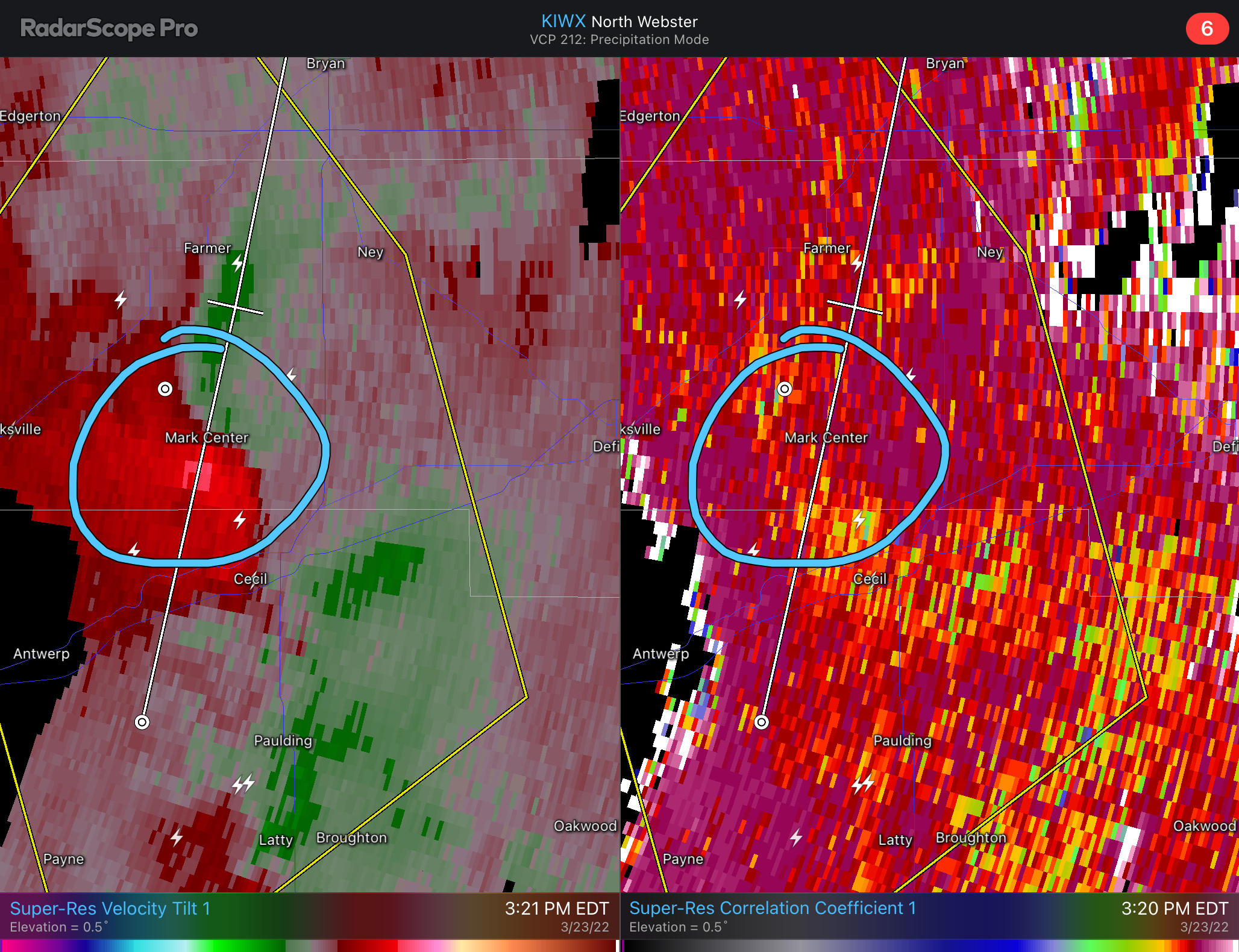
That cell east of San Antonio is ripe once it gets into a higher helicity environment. Great structure and a little isolated from the other cells, could see some serious hail and a strong tornado from it in an hour or so
-
That environment just to the east is significantly better. If this can line up, ooh boy. Great LCL’s and spin ahead of the line, but noticeably better lapse rates and instability where it is now
-
Rain wrapped tornadoes is an odd threat in TX

-
I almost wonder if too much initiation tomorrow could inhibit things but sheesh it looks damn good. Nice boundary going to get laid down by todays storms combined with a pretty damn strong low for this latitude at this time of year
-
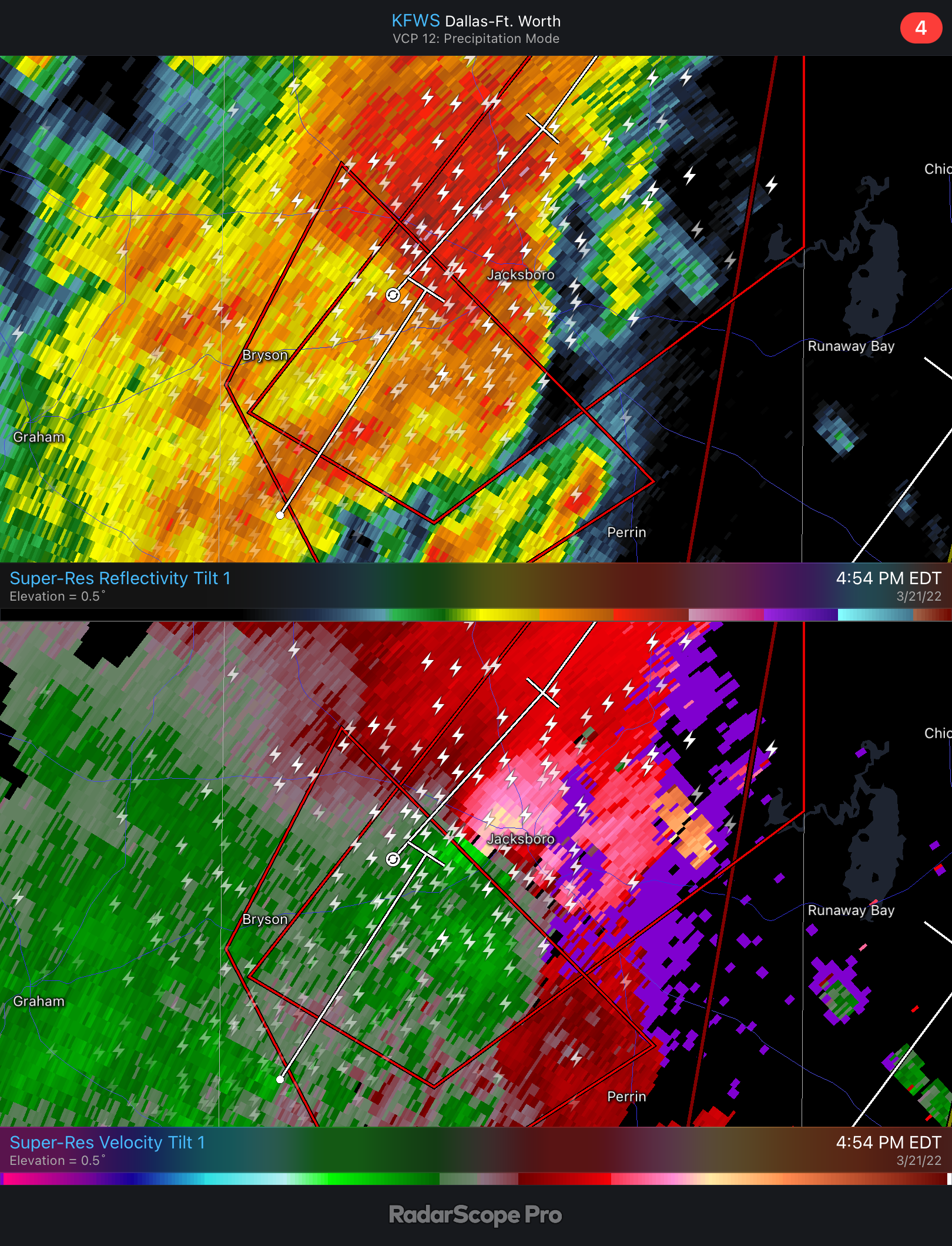
You can tell the environment is loading up ammo in a big way here as that low strengthens. Temps in the 90s down around Corpus Cristi with some serious moisture getting pumped up north. Lapse rates look pretty good for later on as well, the hail threat is going to be legit here. I’m not sold on the strong tornado threat completely lining up today though, it seems the best helicity will stay to the east of the cells but we will see
-
Wouldn't be shocked to see some insane reflectivities today with the hail. I'm not 100% sold on the strong tornado threat today though, the LLJ isn't totally syncing up per models yet with when the cells are expected today
-
I'm a little concerned about that second line approaching Mobile. Ample instability & decent SRH/Shear ahead of it
-
I figured I'd start this as we're looking at a couple active days starting this morning in Southern AL/MS
-
Damn here in Charleston containers were blown off the bridges when the front passed
-
Definitely a hallmark November or March powerhouse front coming on through. 540 line making it almost to Florida on the backside of this is insane for this time of year. I like some legit damaging wind reports to come out of this line tomorrow
-
Not a great setup but I wouldn't be shocked to see some severe reports around lunch time today as this moves east
-
Mid to Long Range Discussion ~ 2022
nwohweather replied to buckeyefan1's topic in Southeastern States
Yeah it's getting pretty bad downtown, king tides regularly flood it -
Lol tradeoffs though. Swimming from mid April to Halloween is a heck of a lifestyle