nwohweather
-
Posts
3,702 -
Joined
-
Last visited
Content Type
Profiles
Blogs
Forums
American Weather
Media Demo
Store
Gallery
Everything posted by nwohweather
-
I’m gonna go with 2-4” for everywhere west of I-75 with 1-2” east of it here in Toledo. I can’t imagine how bad conditions will be in the heart of this storm, absolutely paralyzing to get those winds with this level of snow
-
Should’ve changed into January gale or white hurricane like the old newspaper articles
-
Unreal runs on the GFS... Almost 24 hours out and it's showing 0" essentially on the Euro & 4-6" on the GFS for Toledo. This is insane
-
What in the world...

-
Pretty good agreement on the models here today. Can't say it any different, that's a historic blizzard for this weekend.
-

Winter '23-'24 Piss and Moan/Banter Thread
nwohweather replied to IWXwx's topic in Lakes/Ohio Valley
Tomorrow evening is when the picture becomes much clearer. Sampling occurs, the current system moves out and the NAM comes into play. Patience folks -
Barometer at home officially at 28.90. Can’t say I’ve seen it this low much in my life
-
So often you see the heaviest snows trend more towards the IN border counties west of I-75. We will see here but with mixing it wouldn’t shock me to see Toledo proper shafted a bit
-
Hell of a storm for Toledo on deck, one of the best I've ever seen if it pans out on the GFS.
-
A little out of area, but a PDS Severe T-Storm Warning is in effect for Charleston, SC due to 70-80 MPH winds. A string of warnings in effect from Richmond, VA to Tampa, FL. Just a truly dynamic storm system on display here in the CONUS today
-
Huh? I’m south of Toledo and it’s ripping snow! On a side note, there is a hell of a hook on a supercell just NE of PCB. At the moment SRH values in AL/FL are between 400-800. Going to be a hell of a weather day in the US today
-
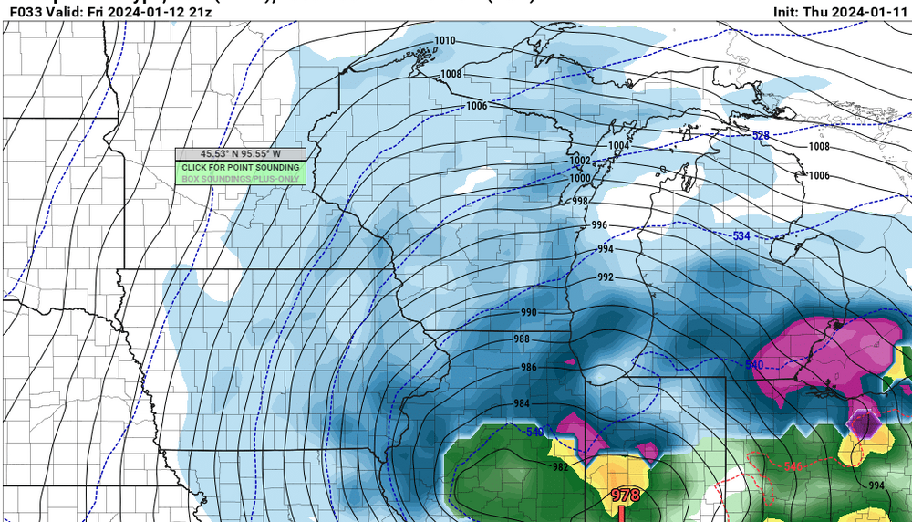
Sub 970 is just wild inside of 100 hours. When is the last time in winter this has even occurred?
-
What has the total snowfall been up there this season? I’m up there sometimes for work (in the quarrying industry) and it’s usually a damn tundra this time of year
-
When was the last major one? Usually, not always these tend to go west
-
To me it's starting to look like a classic Panhandle Hook, especially with that track. I can't think off the top of my head very many times we've cashed in on these systems, Chicago can though
-
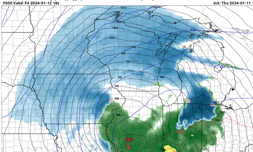
Bingo. It’s one thing that really jumps off the page to me with the guidance thru hour 144, these are some rather impressive SLP’s from a pure barometric standpoint. What I’m curious about is why are we seeing such strength? Typically we see 995ish storms with 6-10” in its strongest swath, not very deep cyclones
-
Why wouldn’t you expect it to trend NW over time? It’s a strong, deepening low that wants to go poleward. The sampling that has been done IMO has allowed the models to produce a more realistic solution. I’m still concerned about the dry air intrusion in that second window, would not be shocked at all to see QPF impacted from the possible MDT risk event occurring in the Gulf Coast region
-
Winter 2023/24 Medium/Long Range Discussion
nwohweather replied to Chicago Storm's topic in Lakes/Ohio Valley
Sheesh. The US-24 special here. This solution occurs, I’m stuck in my house for a week -
Winter 2023/24 Medium/Long Range Discussion
nwohweather replied to Chicago Storm's topic in Lakes/Ohio Valley
I don’t recall if I’ve ever seen a 60+ mb gradient in my life quite like that. 1045 MB high in WCAN and a 970 MB low rushing through the GL is prolific. The thing that made ‘78 so special was that the arctic jet was basically brought down to the surface, wind gusts topped 100 mph over Lake Erie with sustained winds topping out at 80 in Cleveland -
I do think though pure climo is against anyone east of Chicago and Milwaukee getting a solid snow. This is a pretty damn strong low without anything to really keep it from cutting poleward as it bombs out
-
Winter 2023/24 Medium/Long Range Discussion
nwohweather replied to Chicago Storm's topic in Lakes/Ohio Valley
As much as I’ve grown fond of warm, mild weather from years in the South, it’s been 5 years since I’ve seen a snowstorm of any kind. This would be cool to watch -
Damn that's a beast of a storm, but the track is a tad unbelievable at the moment. Arkansas-Indy-Toledo on a storm bombing out? If it really enters the lower GL at around 975 MB then I'd expect more of a South Bend-Lansing low track
-
Heck of a system on there, not often you see sub 980 mb rolling thru the GL. Concerned about the severe side of things robbing this one of moisture on the backside, with the 540 line digging all the way to the GOM and FL I'd expect some serious convection on the southern end of this.
-
I cannot get over how little cold air there is on the backside of some pretty dynamic systems here in the upcoming days. Is it really that hard to get a high pressure on the backside of either of these events like normal to create a legitimate swath of snow?
-
Winter 2023/24 Medium/Long Range Discussion
nwohweather replied to Chicago Storm's topic in Lakes/Ohio Valley
You can tell the pattern is ready to flip in a thunderous way. Mid January should be rocking