

paweather
-
Posts
11,418 -
Joined
-
Last visited
Content Type
Profiles
Blogs
Forums
American Weather
Media Demo
Store
Gallery
Posts posted by paweather
-
-
9 minutes ago, Bubbler86 said:
GFS throwing stuff at the wall now.

Looks good this far out LOL
-
3 minutes ago, Bubbler86 said:
You could have started thing about sprots or something and held out longer so your money shot was this.....

I saw it......But decided against posting at 384 map..

-
 1
1
-
-
The reversal begins:

-
 1
1
-
-
1 minute ago, Atomixwx said:
McKean-Elk-Clearfield-Cambria-
Including the cities of Bradford, St. Marys, Ridgway, DuBois, Clearfield, and Johnstown
220 PM EST Sun Dec 17 2023
...WINTER WEATHER ADVISORY IN EFFECT FROM 1 PM MONDAY TO 10 AM EST TUESDAY...
* WHAT...Snow expected. Total snow accumulations of 2 to 4 inches. Winds gusting as high as 40 mph.
* WHERE...McKean, Elk, Clearfield and Cambria Counties.
* WHEN...From 1 PM Monday to 10 AM EST Tuesday.
* IMPACTS...Plan on slippery road conditions. The hazardous conditions could impact the morning or evening commute.
* ADDITIONAL DETAILS...The periods of heaviest snowfall and travel impacts are expected between 8 PM Monday and 8 AM Tuesday as temperatures drop below freezing.
PRECAUTIONARY/PREPAREDNESS ACTIONS...
The Pennsylvania Department of Transportation and Pennsylvania Turnpike Commission remind motorists to adjust speeds based on driving conditions as winter weather impacts will include snow covered roads and limited visibility.
Call 5 1 1 or visit www.511pa.com for the latest travel, roadway and traffic conditions.
To report snow or ice, post to the NWS State College Facebook page, use Twitter @NWSStateCollege, or visit weather.gov/ctp.
Sent from my motorola edge 5G UW (2021) using Tapatalk
Excellent Enjoy!!!
-
10 minutes ago, Atomixwx said:
I have been advised. Fun.
Sent from my motorola edge 5G UW (2021) using Tapatalk
Advised of what?
-
3 minutes ago, TimB said:
I’m certainly not TCC or the other guy.
Oh OK sounds good
-
3
-
-
46 minutes ago, Wmsptwx said:
Why does it make you so angry to talk about CC? I really don’t get why anger is the response.
Because he has 10 different screen names that’s why. He serves no purpose in here.
-
1
-
-
56 minutes ago, PSUWhiteout70 said:
Opinions vary.
Exactly!
-
1
-
-
2 hours ago, Itstrainingtime said:
Useless to society isn't fair or accurate.
I’m sorry when someone uses 10 different screen names that is useless.
-
4 hours ago, mitchnick said:
Let's just not engage CC or his alter ego TimB. They are not happy souls. Has either ever posted anything positive for cold and/or snow? Of course not, and it's intentional. The whole purpose is to bring everyone down their dark, depressing hole. Best to leave them in their corner alone because they are not here to sincerely discuss weather and there's nothing anyone on this Board can do to cure them.
Agree 100% TimB climate change and dream traveler they don’t have anything to do but jack our forum up all are useless to society
-
1
-
-
2 hours ago, TheClimateChanger said:
Maybe it's just me, but I'm not overly enthused by little more than a half inch of snowfall modeled over a 10-day period, when the current average single day snowfall is 0.3" and rising.
Quiet until Mr Cllmate dream traveler joins.
-
2 minutes ago, mitchnick said:
It includes an inch, gige or take, with the u/l low that swings thru after the big rain and the an inch or 2 on CHRISTMAS EVE!
Keep them coming Mitch....Let's make January fun and white for a change.
-
2
-
-
5 minutes ago, mitchnick said:
Everyone asleep for the Euro? 10:1 and Kuchera.
.thumb.png.8ce273df01822fab0355e510b85dd859.png)
Lookin good!
-
It's a quiet Friday....let's hope WSW are in the air soon!
-
1
-
-
6 minutes ago, Itstrainingtime said:
WPC continues to up the goods:
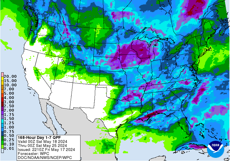
a nice soaker!
-
1
-
-
5 minutes ago, Bubbler86 said:
I did not mean to offend, just stating my opinion. I understand not wanting the drama so my thought was more toward the comments that no one from anywhere but CTP can post. Can't we all get along. LOL.
No worries at all. I didn't take it that way. All good!
-
1
-
-
4 minutes ago, Atomixwx said:
I did. Screw em. I can appreciate the opinion of those who think otherwise. I can appreciate snownut's appreciation for weather reports from East Nantmeal, as it is closer to him than say, Ridgway, and I have said on many occasions that folks like TugHillMatt are more than welcome here, but the trolls, they can go.
Sent from my motorola edge 5G UW (2021) using Tapatalk
Agree!
-
I didn't ask anyone to leave with the exception of staying in their boundaries.
-
1
-
-
1 minute ago, Bubbler86 said:
That fake snow does not cut it. Buffaloians feel your pain.
They better feel it this weekend. Lol
-
1
-
-
4 minutes ago, Dannny said:
Hey all! Was wondering if anyone knows what happened to WX Disco!? The site disappeared within the last few days. Considering I just spent $300 on the membership a month ago I’m not too happy that the site is no longer. Does anyone have any info on to what happened?
????
-
No Red Rose Drop this year so that means it gotta snow on NYE. Breaking of a tradition.
-
Just now, Itstrainingtime said:
Perhaps he will - that won't stop me from being respectful. I can control me, my words, my actions and no one else's.
True. So sick of these people. Your a better person than I am and I respect that. But I am not sorry for my words to these clowns. And if it helps me I will continue to show my peace to them. They do this because they have nothing else to do, come into our forum and act like idiots.
-
2
-
-
19 minutes ago, Itstrainingtime said:
Tim, I understand. I really do. And I told him as much as well. My "issue" is that some of us in here are weather fans, but the majority are into one thing...snow. The board ebbs and flows with the seasons, and it's the time of the year when snow lovers have returned. So, part of my hang up is the "knowing your audience" thing - a lot of people only are interested in reading/hearing/talking about one thing, and that is how are we going to get snow on our yards. The second, related part of it is - we've talked Steelers, downtown Pittsburgh, snow, soccer, and other things. Depending on the season and other factors, all is okay in my book. However, TCC clearly has a singular agenda. It just so happens that his agenda is counter to what the masses want to hear about. And that dynamic, like it or not, even dare I say fair or not, has caused a lot of tension. I'm really trying not to take sides because a part of me sides with your "team." I balance that with the thought of trying to keep this a fun, comfortable place to hang out and chat.
All I can say is this - if I'm told that I'm constantly pissing people off, I'd stop. Right or wrong, I'd stop. And he hasn't, even though he was asked to. That's just my perspective. Again, what I'm really tired with is the constant tension. As Atomix just alluded to, we'd have occasional "spats" (some of which I was a part of) but nothing of this nature. It's concerning.
He won't stop he will come in here from Pittsburger with another name Climate Dick 100.
-
2
-
-
1 hour ago, PSUWhiteout70 said:
Zzzzzzzz. Take your schtick somewhere else, loser.
Agree!!! what a moron!
-
1
-


.png.068a9353ea9789ae9dcd46f7d2318ea7.png)
Central PA Winter 23/24
in Upstate New York/Pennsylvania
Posted
BLizz just keep doing what your doing. I agree I said late next week it begins.