

paweather
-
Posts
11,418 -
Joined
-
Last visited
Content Type
Profiles
Blogs
Forums
American Weather
Media Demo
Store
Gallery
Posts posted by paweather
-
-
On the train track:
-
39 minutes ago, Blizzard of 93 said:
Exactly, highs in the teens here with freezes to the Gulf Coast often means suppressed storms.
Give me “cold enough” all day.
Right on track Blizz.
-
 1
1
-
-
11 minutes ago, TimB said:
Helps that modeled temps are sitting in the lower 20s at the height of that thing.
Didn’t you go back to Pittsburgh?
-
 1
1
-
-
6 minutes ago, Voyager said:
That shafts Tamaqua. Toss it...
Your in Zona right?
-
27 minutes ago, mitchnick said:
Don't look now, but 2/10 just walked in the door. Sharp north cut-off included.
.thumb.png.c4f2baee42d5a90a43e533c7ba10f906.png)
HAPPY HOUR!
-
6 minutes ago, Blizzard of 93 said:
The pattern supports chances….
Yes it does for sure
-
Just now, Bubbler86 said:

Sweet!
-
6 minutes ago, Bubbler86 said:
Cold air and lower heights retreating as we enter the middle of the first week of the new year on the 18Z GFS.
Only 6hrs before it changes
-
1
-
-
1 hour ago, TimB said:
Uh oh
Thanks for the forecast. Pittsburgh is calling your name now.
-
1
-
-
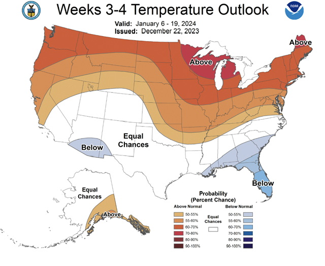
3 minutes ago, Blizzard of 93 said:
“Leaning Below” according to their key.
40 to 50% chance of below… so I guess that means around 50% chance of Above or Normal?
First week in January @Blizzard of 93looks good!
-
1
-
-
4 minutes ago, Atomixwx said:
Good. Despite the thumping I'll take from the fuel oil folks, that really is the desired result.
Sent from my motorola edge 5G UW (2021) using Tapatalk
You got it my man. New Year and more SNOW.
-
12z GFS looking good for a Cold Start to the New Year and possible snow!
-
7 minutes ago, Blizzard of 93 said:
Sorry that I lost my cool this morning.
I am generally entertained by your posts.
I hope that you & your family have great holidays.
All good @Blizzard of 93 we know the pattern is changing. Just not the specifics of when yet.
-
5 minutes ago, mitchnick said:
No way slp would head for the GL with the ensemble mean 500mb and 250mb wind flow.
Thanks Mitch notice @Bubbler86did the GFS takes it into the lakes. I hope this is the one,
-
5 minutes ago, Superstorm said:
Was just about to post that. Yes, great to see it respond.
.Yep here it comes....
-
1
-
-
-
2 minutes ago, Bubbler86 said:
Late nooners. Mostly Sunny and 35.
Nice chilly nooner 43 and Sunny here.
-
1
-
-
1 minute ago, TimB said:
None of those years start with 2. Strange.
So Strange.
 Climate change is our death.
-
2 minutes ago, TheClimateChanger said:
Assuming less than 3.5 inches falls between now and the end of the month, this is the third lowest 5-year snowfall on record at MDT - behind only the 5-year periods ending on 12/31/1934 & 12/31/1992.
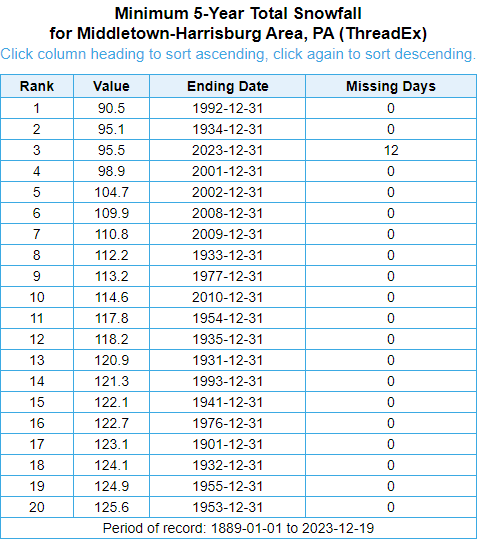
OMG how did I know Climate Changer would in the house telling us about anti snow.
-
1
-
-
3 minutes ago, Itstrainingtime said:
Elliott on next week's rain potential (and beyond):
Not until next Tuesday or Wednesday should a storm system move into the Ohio Valley and mid-Atlantic States and bring the next round of unsettled weather to the region. This system will likely bring rain to parts of the Deep South, Tennessee Valley, and Midwest on Christmas Day but face resistance from the large high pressure system over New England. Regardless of the system's timing, temperatures will be way too high and the storm track too far north/west for any wintry precipitation in the entire mid-Atlantic region. Thus, another soaking rainfall is a "good bet" at some point during the middle of next week, but amounts should not be high enough for any more flooding concerns. As mentioned, it will also be another "mild rainstorm" with temperatures in the 40s or 50s. 'Tis the norm in December during strong El Niño winters. As for snow and ice, the tide may turn in early- to mid-January, but it'll be a "no-show" until then. Cue the old adage, "Patience is a virtue".. -- Elliott
Elliot has been spot on. He has not wavered at all with his predictions. and @Bubbler86 correct on the MA forum. Lots want it to snow snow snow like myself but as Elliot says we need patience. I don't have much of that but trying hard. LOL.
-
1
-
-
1 minute ago, Bubbler86 said:
Yea, on the 6Z. Eastern side of the country is evacuated of BN temps on the 27th. Not a torch either, just mild. Colder air works in after Jan 1 but only for a few days as it looks transient. Just a PBP on an Op model, not a forecast.

Yep. Let's see what we get today. PBP is good and certainly if 6z is correct that is what happens.
-
26 minutes ago, Bubbler86 said:
Several 50's on the GFS for post-Christmas week into New Year Day so if that is close, it will probably rise indeed...from the current 3.2.
Reviewing 6z? Makes sense...we shall see.
-
29 and Sunny. Weather will be headed in the right direction after Santa.
-
Nooner 35 and Flurries feels like winter.
-
2
-

.png.3425e6f25611383000088b16814b0723.png)


Central PA Winter 23/24
in Upstate New York/Pennsylvania
Posted
Pittsburgh calling?