

paweather
-
Posts
11,418 -
Joined
-
Last visited
Content Type
Profiles
Blogs
Forums
American Weather
Media Demo
Store
Gallery
Posts posted by paweather
-
-
1 minute ago, Bubbler86 said:
I have to do something to counteract the silly comments I get about not using guidance past a certain hour....this after watching the big boys flip and flop today.
Lots of flip and flops today but that is all the time. I am still liking the chances of a quick 4-8" type storm. Power El Nino like.

-
 1
1
-
-
9 minutes ago, Bubbler86 said:
NAM AT RANGE WARNING----NAM AT RANGE WARNING
At 84 hours the SLP is on the cusp of the Gulf near New Orleans in a very similar position as the 12Z CMC. The approaching High is displaced a bit East vs, the CMC. Looking at 500H it is going to go North East in some manner but would be guess work to suggest how.
NAM at range warning. You serious? LOL.
-
27 minutes ago, canderson said:
I was not ok last night …
Better than State College even a 12 team playoff we will likely be out of with Franklin our coach.
-
1
-
-
14 minutes ago, MAG5035 said:
To further on the 12z Euro EPS
3”+ probs
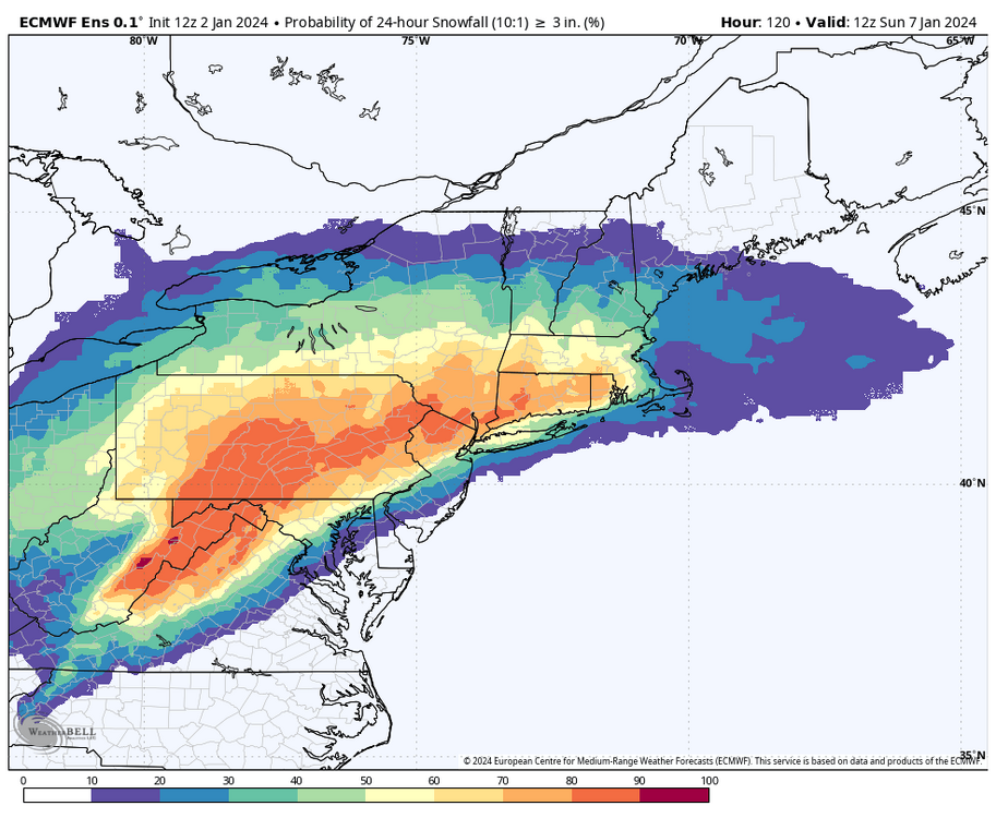
6+ probs
Maybe
Edit to note that the 12”+ probs are completely non-existent (no ensemble member showing 12+), so the ensemble overall has definitely picked up on the faster motion of this storm.
Maybe more like a 3-6 4-8 storm for us. Outside of this one model run. 18z up in the next couple of hours.
-
3 minutes ago, mitchnick said:
Geps a whole lot better than 0z run
.thumb.png.33d364369fbf75543617a26a60ae4a8f.png)
A PA Plower.
-
1
-
 1
1
-
-
Tough Loss @candersonI was rooting for them.
-
 1
1
-
-
6 minutes ago, Blizzard of 93 said:
Low is in a great spot, just need to slow it down a bit & ramp the precip back up.
4 days to go, but I would be good with a region wide 5 to 10 of snow.


Let's do this one Blizz.
-
1 minute ago, Bubbler86 said:
Parts of the MA lost over 1/2 foot.
Yep this is really becoming a PA snowstorm. Intense and quick.
-
2 minutes ago, Atomixwx said:
Remember: For some weird ass reason, the biggest storms tend to happen on weekends.
Sent from my motorola edge 5G UW (2021) using Tapatalk
Get the snow shovels ready!
-
21 minutes ago, mitchnick said:
I think we're ok. There's enough model support for at least 4" at this range imho.
100% agree. Model support for at least a 4-6" storm if not more.
-
1
-
-
2 minutes ago, Bubbler86 said:
The GFS does drop warning level snows before any change over so not terrible...to clarify. Just not a strictly snow system with the proximity of the vort. Almost no snow for MA cities.

Just going to post that....crushed before a changeover.
-
5 minutes ago, Wxdavis5784 said:
ICON @ 6z
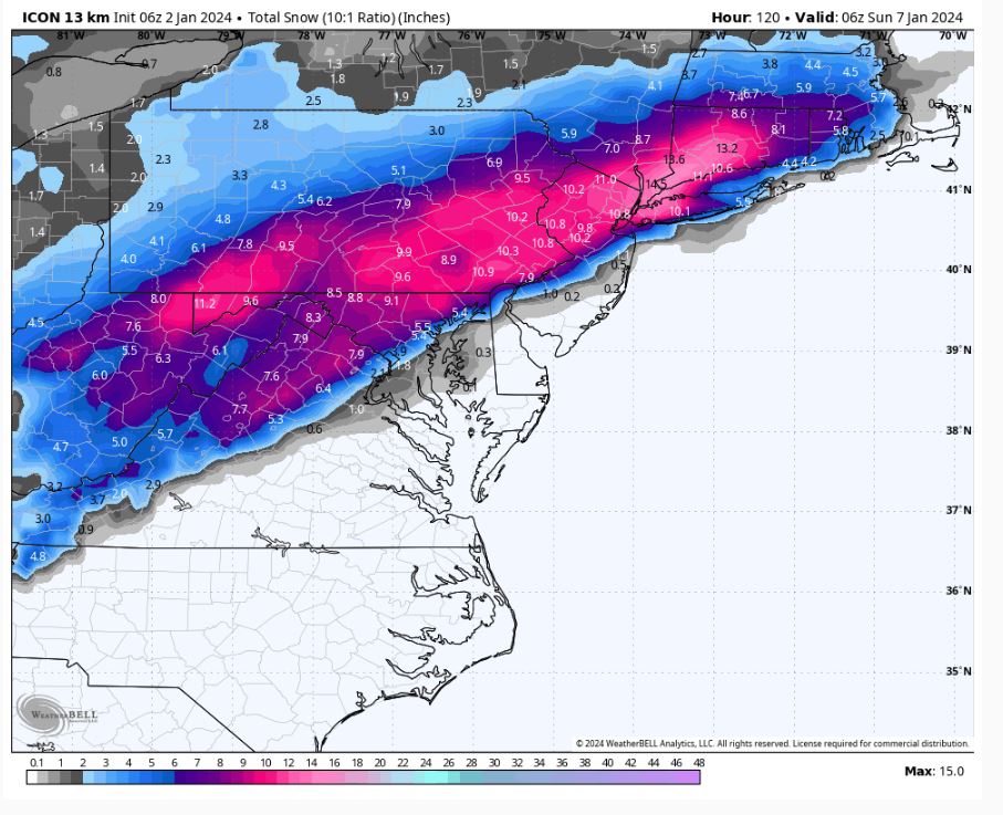
@ 12Z
Sweet either way!
-
CTP thinks we are in play!
SaturdaySnow likely after 2pm. Mostly cloudy, with a high near 37. Chance of precipitation is 70%.Saturday NightSnow. Low around 30. Chance of precipitation is 90%.SundaySnow. High near 36. Chance of precipitation is 80%. -
17 minutes ago, Wxdavis5784 said:
WGAL certainly mentioned potential significant snowfall this morning.
They did last night as well. I think we are all ready for this to happen.
-
1
-
-
Just now, Blizzard of 93 said:
Wow!!! Crushed!


Great run!
-
4 minutes ago, MillvilleWx said:
Thanks! It feels great to be back on the east coast and I get to actually track something for my back yard again

I think the trends right now are positive for the LSV and south-central PA area. I would imagine the favorable spots along the Mason Dixon up to the turnpike are in a good area for the time being. Too early to talk totals, but the key will be the storm not going too far south and the confluence to the north doesn’t thwart latitude gain. Analogs right now are pretty solid for the region, so I like where you guys sit at this point. I’ll come by and add some insight as we approach. Perhaps a snow map is in order!! Been awhile since I did one for the subforum.
Let’s see one
-
5 minutes ago, MillvilleWx said:
Howdy everyone
")
This only means good things shall happen
-
1
-
-
4 minutes ago, Itstrainingtime said:
I am all about snow cover. Normally, I would prefer 4" of snow that lasted 2 weeks than 12" of snow that was gone in 3-5 days.
These aren't normal times. I haven't shoveled in 2 years. If we get 6-12" of snow that is completely washed away a few days later, so be it. I'll be thrilled to put up a big crooked number.
Exactly!
-
Crushed!
-
1
-
-
Almost time!
-
Where’s TimB negativity now?
-
1
-
2
-
-
Just now, mitchnick said:
Geys pished along this run by trailing waive keeping totals more in the 6-10" vs. 10-14"
6-10 perfect!
-
Just now, mitchnick said:
Should be a great run methinks
That’s what I think as well way overdue!
-
2 minutes ago, mitchnick said:
Gunna be a little further north than 0z. High in Canada 2mb weaker and heights along the coast a bit higher.
Me liking

.png.ef1045fbcb6d0cb8b20536e931d0e977.png)


Central PA Winter 23/24
in Upstate New York/Pennsylvania
Posted
CTP: