

paweather
-
Posts
10,467 -
Joined
-
Last visited
Content Type
Profiles
Blogs
Forums
American Weather
Media Demo
Store
Gallery
Posts posted by paweather
-
-
8 minutes ago, Bubbler86 said:
PA snow map for Wed....very little rain over us....quick snow to taint then dry. Surface temps in the 40's for the LSV when dry slot hits. A little rain as the dry slot approaches.
I'll take 3" of digital snow! LOL. Let's hope we get a better thump upfront on the next run or 2.
-
 2
2
-
-
2 minutes ago, Bubbler86 said:
Was wondering why no one posted about the GFS Feb 3 threat. I figured it was failed digital blue syndrome.
Need some lift when it hits the coast


-
1
-
-
6 minutes ago, Itstrainingtime said:
That certainly seems like our best chance for those us down this way. Have a pretty decent feeling about it.
All Aboard!!! I am on the train with you.
-
1
-
-
1 minute ago, pasnownut said:
Dont look, but beyond mid next week.....
the pattern looks decent. I know...doesnt it always?
Gut says this SHOULD be legit period of fun.
Happy almost weekend to all.
I agree I looked as well. It will change for sure. Happy Weekend!
-
GFS rainstorm for Wednesday.
-
11 minutes ago, Itstrainingtime said:
12z Icon with a low over Erie next Wednesday that still manages to snow on all of PA except the extreme western counties and SE of I81.
And a Low off the coast on Sunday with rain in mid January,

-
Well Lebanon County weather isn't giving up:
Good Friday morning! SNOW LIKELY SundayAnother cloudy and breezy day is on tap. Temps today will again be held in the middle 40s. A stiff NW breeze will make it feel cooler so dress warm.Saturday will feature partly cloudy skies with temps holding around 40 degrees.As addressed in the header, snow is coming, and it's coming Sunday! How much? Likely several inches, but the details will need to be worked on, so a FIRST FALL can be expected later today, around 3 or 4 pm. -
22 minutes ago, MAG5035 said:
Not sure why my WB hasn’t loaded any of the 0z GFS in yet but in the meantime.. here’s the early prediction sure to go wrong just issued from CTP.
GFS has been slow.
-
45 minutes ago, Bubbler86 said:
0Z NAM good for the Central and Southern LSV and the LV. Misses North and West of there.

I mean we are down to 3 days how can anything go wrong
-
34 minutes ago, Blizzard of 93 said:
The 18z Euro has a good low track for Sunday from eastern NC to the southern DelMarVa to Atlantic City, NJ.
It delivers a solid Advisory event to most of CTP. It looks to be juicing back up again, so with this track, hopefully we can ramp up snow amounts a bit closer to game time.


Blizz you got the luck!
-
3 minutes ago, canderson said:
Friday will be windy af around these parts.
Canderson winds strike again.
-
HH GFS time for it to be Happy and cheery cheers!
-
1 minute ago, Itstrainingtime said:
18z NAM not backing down:

That is pure LOVE! for 6 hours LOL.
-
1
-
-
33 minutes ago, Blizzard of 93 said:
The 12z GFS & 12z Canadian still bring an Advisory level event to MDT and most of CTP Sunday into Monday.


Still in Play!
-
9 minutes ago, Itstrainingtime said:
@paweather - CTP just provided their PM update. They added a mix of rain/snow to grids for Sunday, lowered temps some, but mention in their discussion that it'll be a rainstorm SE with a mix across central PA.
They also talk about next week and say that models showing a cutter "makes sense" given the alignment of the ridge axis off the west coast.
Thanks!
-
2 minutes ago, Atomixwx said:
That's a weird, not-likely resolution.
Sent from my motorola edge 5G UW (2021) using Tapatalk
Any resolution that doesn't have snow seems to be always correct. LOL
-
1 minute ago, pasnownut said:
Great call.......

Luck changer!
-
Gotta change the luck in here. I'm calling it now. Winter is Over!
-
 1
1
-
 1
1
-
-
4 minutes ago, pawatch said:
Been awhile since I have seen the Nam get so much love.
Even at 84

nooner: 37 and rain.
Whatever model that has snow in my area is the one I use!
-
2
-
-
1 minute ago, Bubbler86 said:
If you want to believe the little to no inland push scenario on the nam, the icon is the leader (IMO) there.
It is starting to come together.
-
2 minutes ago, Itstrainingtime said:
CTP won't update the weekend until this afternoon's package. They'll finesse today's rain over the next several hours and will then turn their attention to the weekend thereafter.
Yeah agree. Let's see what the GFS does.
-
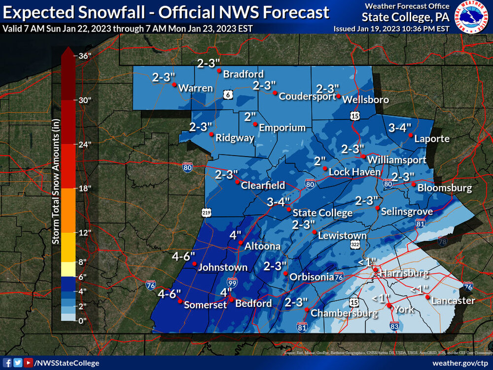
CTP wants nothing to do with Sunday and really nothing for Wednesday.
-
2 minutes ago, pasnownut said:
I'll "nice call" myself.....
That is a good call.
-
1 minute ago, Bubbler86 said:
Nam @ 84 is a hit for the LSV with Light to Mod all around.
Yeah it is the Nam at 84 but we hang onto something until the GFS run.
-
1
-


Central PA Winter 2022/2023
in Upstate New York/Pennsylvania
Posted
Now that is a cheers!!!