

paweather
-
Posts
10,465 -
Joined
-
Last visited
Content Type
Profiles
Blogs
Forums
American Weather
Media Demo
Store
Gallery
Posts posted by paweather
-
-
Just now, Blizzard of 93 said:
I passed out when I saw the full 18z GFS snow total map through 384 hours….wow!
LOL Love it!!!
-
@Blizzard of 93hope you have 0z covered the morning and afternoon group are tired

-
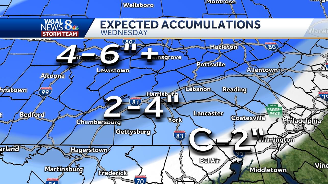
WGAL update:
#WINTERWEATHER UPDATE: Here's what to expect for our Wednesday! This could be the first plowable #snow for much of the Valley! The farther north you live, the heavier snow you'll see. 2-6" is possible! Stay tuned for our latest! #pawx #weather wgal.com/weather WGAL News 8 Storm Team WGAL News Channel 8 Susquehanna Valley, Pa.

-
 2
2
-
-
-
Happy Hour

-
Doesn’t look that bad to me
-
18 minutes ago, Itstrainingtime said:
I was caught on company security cameras watching today's models:
https://www.youtube.com/watch?v=HtTUsOKjWyQ
Classic!!!!
-
 1
1
-
-
15 minutes ago, pasnownut said:
Thats about as good as we can get w/ this setup. Nice to hear they are "on board" with us weenies....
")
Yep they are certainly on board!
-
Great update!
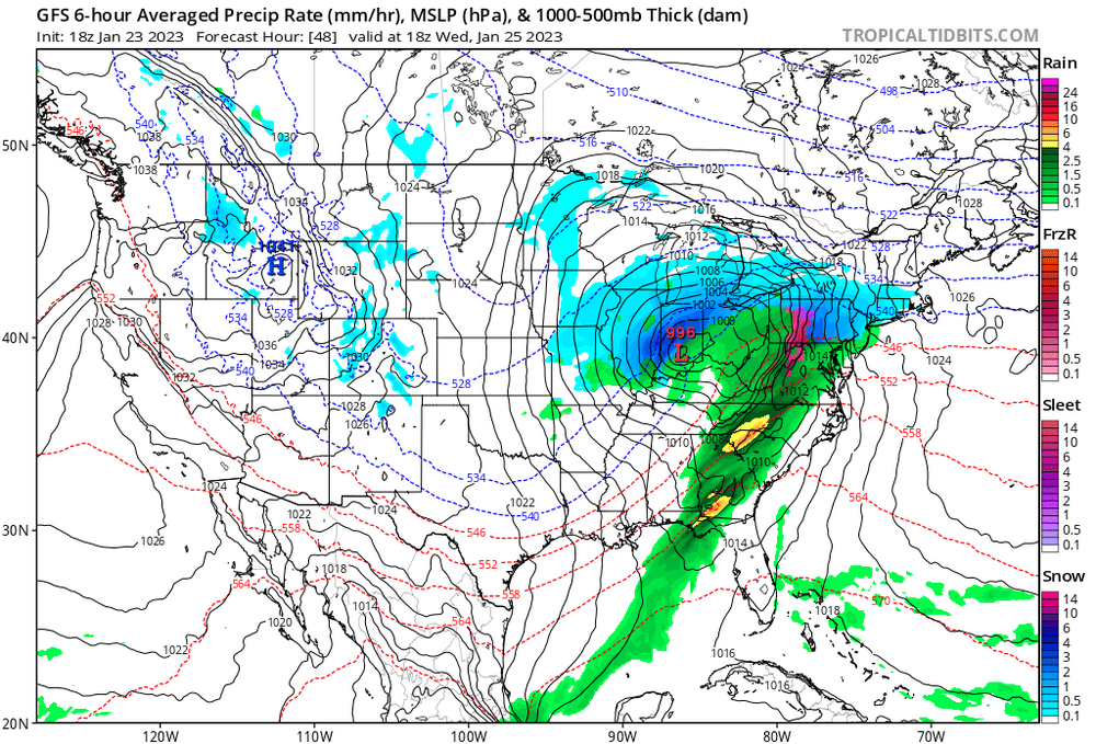
.LONG TERM /TUESDAY NIGHT THROUGH MONDAY/... Noon Monday Update... Just some minor adjustments will be made to timing and QPF/Snowfall amounts at this point for late Tuesday night/Wed in order to preserve consistent messaging next Winter Storm that will soon be taking the NE turn toward us from the Llano Estacado and Permian Basin of West Texas. It looks like the period of snowfall from this upcoming storm will be associated primarily with the period of moderate to strong UVVEL from a potent, southerly low to mid-level jet and its WAA. The track of the primary low is seen by the majority of model Guidance heading into the Ohio Valley with the nose of a strong, 60KT south- southwesterly LLJ creating an approx 6 hour period of strong isent lift and a cross-hair pattern on regional timesections between 12-18Z Wed, where the max UVVEL and DGZ zone intersects. This should bring widespread MDT to HVY snowfall rates of 1-1.5 inches per hour for much of the mid to late morning hours Wed, and into the mid-late afternoon hours across the NE part of our CWA. Afterward, a transition to sleet/freezing rain and gradual decrease in intensity will occur as first a deepening layer of above freezing Tw air aloft races north over us, followed by the deeper, seer-feeder cloud layer into the DGZ peeling away to the NE leaving warmer clouds confined to the layer up through about 8-10 kft AGL. Temps Wed afternoon and evening will only inch up to the 30-33F range across much of the Central and Nrn Mtns, but should climb just above freezing across the region near and to the SE of interstate 81, changing the snow/mix to plain light rain or drizzle Wed evening.-
2
-
-
Late nooner 38 cloudy and raw
-
6 minutes ago, anthonyweather said:

.Looks good in my book!
-
3 minutes ago, anthonyweather said:

Euro for your pleasure.
Can’t be disappointed with a large swath 3-6” ISO 8 storm, in this winter at least
.Nice!
-
3 minutes ago, pasnownut said:
Oof. Add the Euro to the jog north with thermals camp.
Did NOT expect that......but the term atmospheric memory comes to mind right now.
I may need to go get a jockstrap and cup....this may hurt a little.
Still showing about 3" here.
-
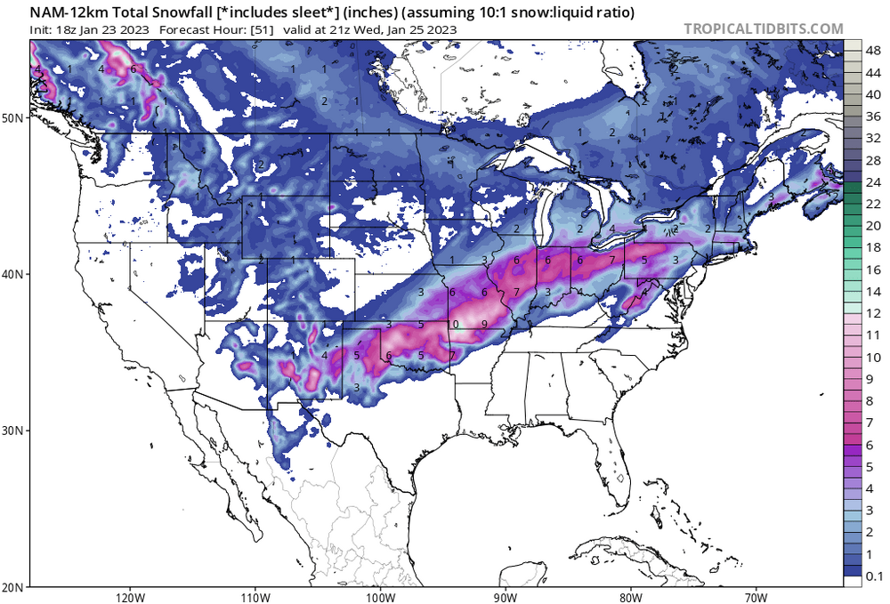
CTP call of 2-4 might need to lowered to 1-3
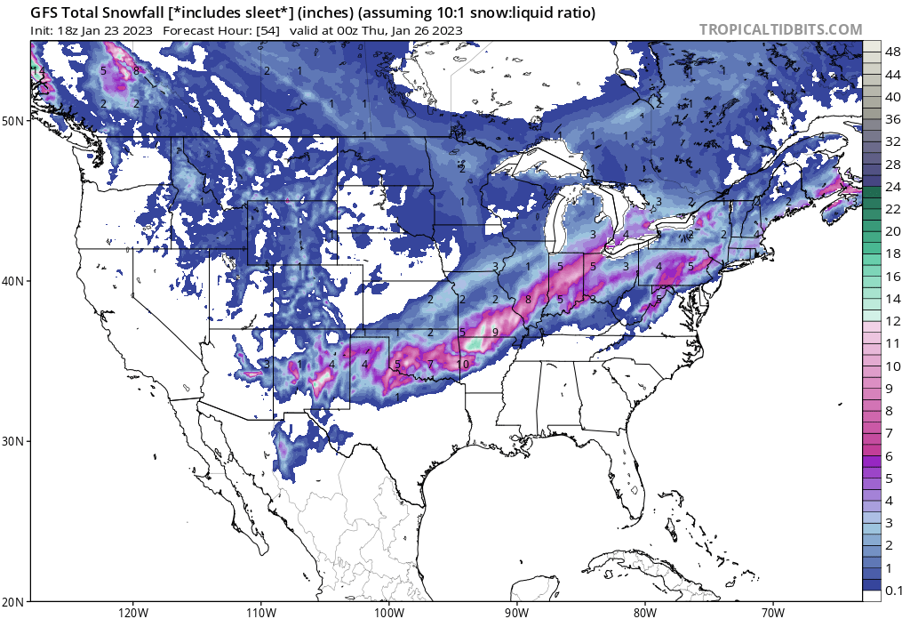
Edit: 5-9 in State College WOW.
-
When are Winter Storm Warning going to be posted?
-
CTP my first accums in the forecast of 2-4" on Wednesday.
-
2
-
-
Cutters giving us snow.....Interesting but will take it.
-
10 minutes ago, Blizzard of 93 said:
The 0z GFS also has the tomorrow am snow for the LSV with 1 to 2 inches.


Yeah 1-2” sorry not enough of DIGI snow for more
-
16 minutes ago, Blizzard of 93 said:
Best EPS run of the day for the Wednesday thump for all of CTP.

Keep bringing the good luck Blizz
-
9 minutes ago, Bubbler86 said:
With a low in the mid-west that seems to be our fate either way. No one I saw posted the Icon, can you blame them after how it handled this system, but it snowed for quite some time at 18Z. Dawn to dusk in the LSV.
ICON equals weenies model like me. LOL
-
 1
1
-
-
Just now, Itstrainingtime said:
The SE edge of the blues is advancing northwest the past 24 hours. Might not matter for some but it means a lot for you and me.
My expectations are low for Wednesday. Very low.
Whatever we get it washing away UGH
-
@90 artic air but the country is dry UGH
-
@72 wash away
-
@66 high is in a good spot


Central PA Winter 2022/2023
in Upstate New York/Pennsylvania
Posted
Not sure what that means great melt most models have 3-4” for the area