

paweather
-
Posts
11,418 -
Joined
-
Last visited
Content Type
Profiles
Blogs
Forums
American Weather
Media Demo
Store
Gallery
Posts posted by paweather
-
-
Look at that low tucked and ready to move NE.
-
Beautiful:

-
1 minute ago, Bigfoot said:
Yes all speculation even that far out
it is certainly not progressive.
-
 1
1
-
-
5 minutes ago, Bigfoot said:
Euro Laughs at GFS again!
Truth. @ 48h.
-
Here we go. Init 0z EURO.
-
-
That is a pretty juicy storm down to our south heading this way. Rain/Snow coming soon to be our appetizer.
-
Let's do this. Soon EURO.
-
Time to get ready for the 0z EURO.
-
Just now, Blizzard of 93 said:
Here is the 0z Canadian super zoomed in for CTP. The 10 to 1 map is impressive, but the Kuchera map should be illegal!


Blizz Love it!
-
-
4 minutes ago, AllWeather said:
00z CMC goes full
 over my house
Allweather been showing this run after run. One more tonight EURO.
-
-
-
5 minutes ago, Voyager said:
What's the GFS seeing that the other models aren't? The Poconos above I-80 don't really get much. That dip south puts me on a tight gradient, perhaps not even seeing a foot here. I believe this is at least the second run that's done this.
I'll let the experts to tell you but it is the most progressive model of all of them at this point. * Meaning more confluence than other models.
-
CMC rolling.
-
Another run:

-
-
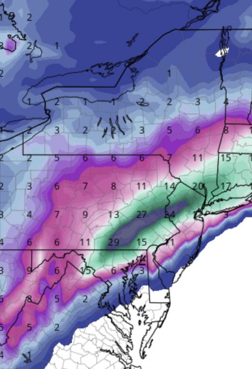
Just a classic look:

-
Looks like a skeleton crew tonight. Lets bring it home. GFS/CMC/EURO.
-
These Med Range Models just don't like tomorrow. 0z GFS ready to go,
-
-
Crush Job 0z NAM.
-


Central PA - Winter 2020/2021
in Upstate New York/Pennsylvania
Posted