

paweather
-
Posts
11,418 -
Joined
-
Last visited
Content Type
Profiles
Blogs
Forums
American Weather
Media Demo
Store
Gallery
Posts posted by paweather
-
-
1 minute ago, Itstrainingtime said:
Interesting that both the RGEM and now the GFS align the heaviest snows from the Lehigh Valley into New Jersey. Areas to my west get less. Not sure what to make of that...I guess better coastal development?
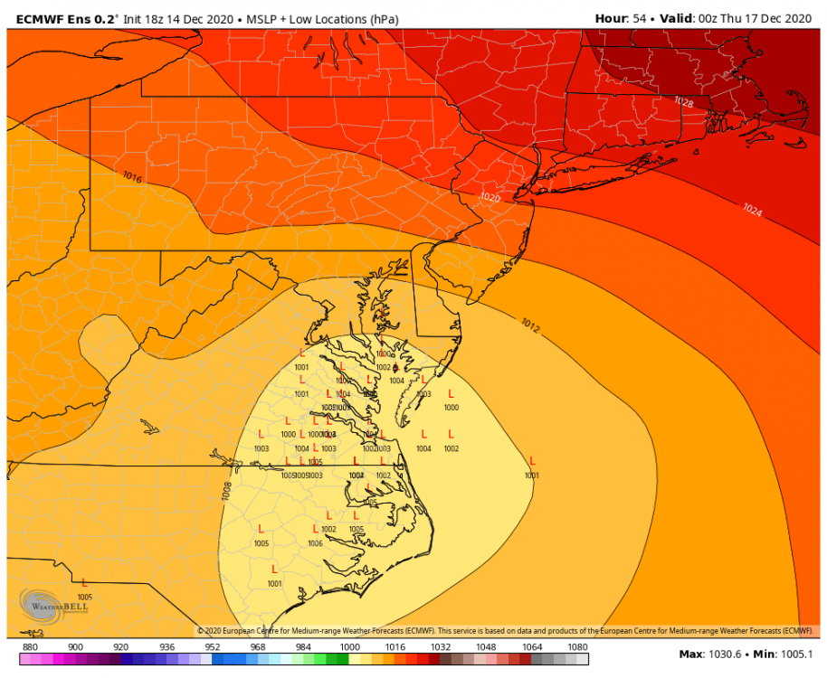
The Coastal has literally been in the same position for several model runs. It is really just a matter now do I get 12" or 24" or 36".
-
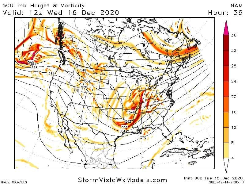
GFS held at 54. Good stuff. Forget the snow maps from the GFS.
-
Just now, canderson said:
I’m ready for the big boy runs.
Love it!
-
-
0z GFS is running.....
-
Just the start of the RGEM it is buckers.
-
-
Just now, Atomixwx said:
Yes. Including 36°F and rain. Don't bring this year into it.
 Not going happen with this setup but I agree,
-
3rd shift crew let's do it.
-
It's 2020 anything can happen!
-
Just now, Blizzard of 93 said:
How about 30 “ ?!?!?!
The 3k NAM is out of this world!!!
Yep I figured. When I saw the setup.
-
40"
 it is 2020 so you never know. LOL. Just kidding, let's get this.
-
 1
1
-
-
-
Nam'd we knew it would happen, not saying this is the solution. But it is at least nice to see.

-
1 minute ago, pasnownut said:
More uniform western expanse of qpf early on.
Primary not dying?
-
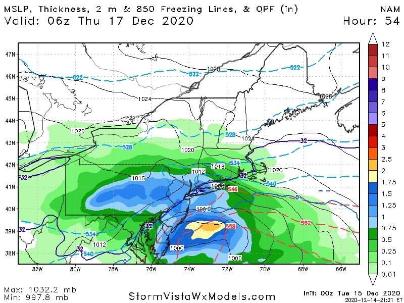
Wednesday 4pm:

-
 1
1
-
-
1 minute ago, cfbaggett said:
And there may be timing differences amongst the members, so some that are east, could have been further west an hour or two earlier. Anyway, it all looks really exciting, regardless.
Thanks again for sharing.
-
2 minutes ago, cfbaggett said:
The green is a mean, median longitude is a tad west.
Yep but pretty consistent with the model runs over the last several days.
-
We are going to get Nam'd.
-
1 minute ago, pasnownut said:
I hope the 4 WAAYYY east outliers can offset the 14 western outliers. Ughh.
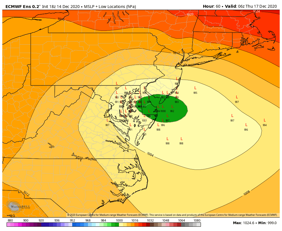
The green marks the spot and has been consistent on the models.
-
2 minutes ago, cfbaggett said:

Thanks for sharing.
-
Out to 24.
-
Soon time to Kickoff 0z.
-
5 minutes ago, Blizzard of 93 said:
The low again gets to southern Delaware and then starts crawling east from there to off of the coast and continuing eastbound!
This run, any mixing in York & Lancaster goes back to all snow as the low turns slightly to the east and off the coast!


The trends today suggest this goes into Thursday afternoon instead of shutting off Thursday morning.


Central PA - Winter 2020/2021
in Upstate New York/Pennsylvania
Posted