

paweather
-
Posts
10,458 -
Joined
-
Last visited
Content Type
Profiles
Blogs
Forums
American Weather
Media Demo
Store
Gallery
Posts posted by paweather
-
-
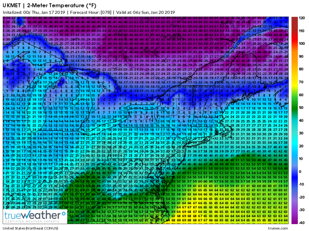
Per EC 0z 2M temps below 32 and in the mid 20's through 18z Sunday (1pm) lots of ice for us. back to snow.
-
1 minute ago, daxx said:
Yes
DAXX Thank you man.
-
Just now, 2001kx said:
Im no Met but that looks good for C-Pa to my eyes.
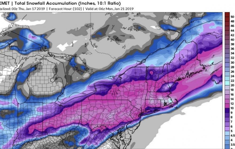
yep. You got it. Good luck things are falling into place. Your in a good location. 12" plus. < less than 12 to 8" no rainstorm that is for sure for us here.
-
2 minutes ago, daxx said:
Damn cold Monday morning! Has most of us below zero!
below zero down here. :-)
-
Williamsport, dude. get your shovel ready. This is going to be one of a historic storm. I still think it will come in colder for LSV lots of cold air. Lots of sleet/FR rain. Pretty much we get a great thump to start. 8-12" LSV is my call. and yes, Horst I know you can prove me wrong but model trends are trends. See you tomorrow folks.
-
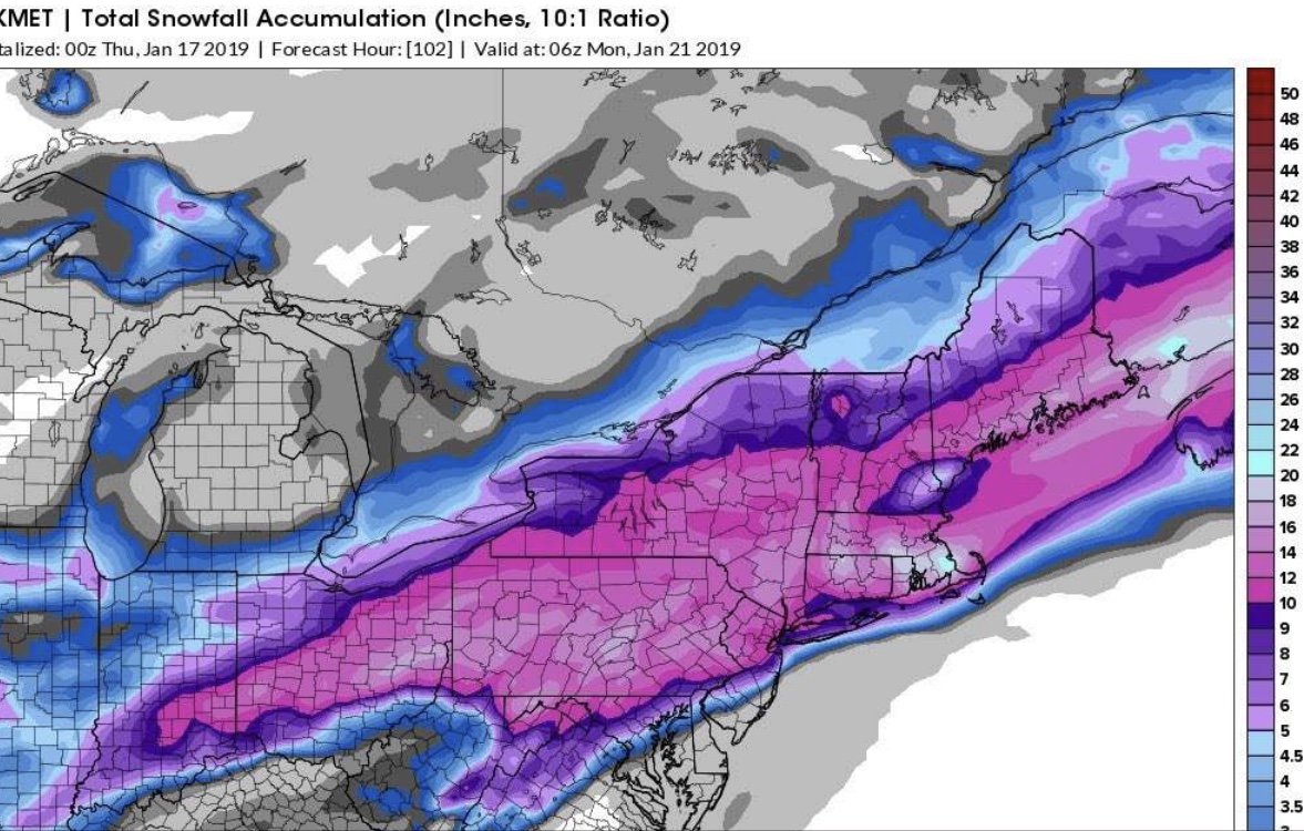
Pummeled before we change over:
.thumb.png.803ef9785c5ca1f5f60301ae41e5707f.png.a5feb5293206d540a645381fbb8b8fed.png)
-
Just now, Stormlover74 said:
Not quite Pittsburgh but northern WV
and it doesn't transfer it just heads east. This is what you want up in NYC. That is why you see the snow totals.
-
OK Here we go EURO. I will try to maneuver through the other forums.
-
1 minute ago, 2001kx said:
LOL. haven't seen his name in a long time. I don't know what to think.
-
Just now, USCG RS said:
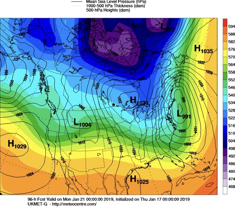
Im saying it's a model depiction. I believe thr Ukie has the right idea but it's not there yet. I don't believe this is a transfer situation.
Sent from my SM-N960U using Tapatalk
Thank you. it is a low moving east based on the boundary. We all need that boundary to setup to the south. All you need to do when a model runs is look at Canada.
-
 1
1
-
-
I really think we need a new thread for this weekend. 1-3" tomorrow night and Friday and then our weekend storm.
-
Just now, Blizzard of 93 said:
That is a beautiful UKMET map !!! Wow!
Yep. Let's go Euro.
-
2 minutes ago, USCG RS said:
Yeah. I'm guilty of this here. I didn't look at the LP in the frame before it scoots to the delmarva
Sent from my SM-N960U using Tapatalk
yes you are correct there is no miller B at all. There is no secondary. Good work. It is a matter of if the HP is strong enough to suppress it to our south. UKMET shows that.
-
This is hardly a miller b scenario.
-
Gosh these other sub forums LOL. Primary to Pittsburgh? I love it.
-
-
1 minute ago, paweather5 said:
Nice!
-
Well I was sucked in, didn't think I would stay up for the EURO. Anyone here have PBP and again thank you DAXX for last night being on vacation. If not I will go to NYC forum who is still talking about Hurricane Sandy :-)
-
Just now, paweather5 said:

Beautiful!
-
16 degrees in in Harrisburg as the high Monday. Come on Artic press down prior a bit don't let the southern stream take everything.
-
1 minute ago, MAG5035 said:
I think if the low does just that and doesn't press into PA or get really close to the mason dixon line that things will eventually work out for the majority of the forum in favor of mostly the frozen stuff. We don't really have a mixed bag of guidance with some models cutting west or through PA vs going south. We're getting down to resolving the details of p-type, which of course is always the hard part with these types of systems.
You and bubbler have called it phased versus a low riding the underneath and to the south of PA. This is quite interesting. Model camps are all over place. Forget the NAM right now. Last night's 0z GFS told me that the HP in Canada will be strong and that is the key IMO. Great guys. Plenty on the table. More importantly snow will be flying tomorrow night and then again on Saturday just how long Saturday for us in LSV. Good trends again.
-
Just now, bubbler86 said:
Thanks for that. More good news. Big picture things are trending toward that LP staying south of us.
Sure. I feel like this is still a good first part thump, ice/rain/ then backend snow that will be in 8-12" range. OK sissy not staying up for you, be good to your brother.
-
 1
1
-
-
Just now, paweather5 said:
Thanks for posting.
-
It goes south of PA off the Delmarva. :-) Just some added mixture into this recipe. 12" plus.

Central PA - Winter 2018-19
in Upstate New York/Pennsylvania
Posted
For you me too! You are looking good.