

paweather
-
Posts
11,418 -
Joined
-
Last visited
Content Type
Profiles
Blogs
Forums
American Weather
Media Demo
Store
Gallery
Posts posted by paweather
-
-
-
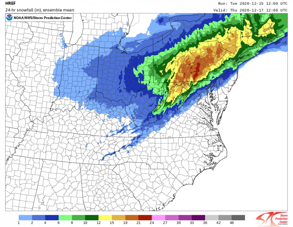
Being NAM'd again.
-
sorry about the EURO only get 24HR increments. from 24 to 48 it jumped east so everything else in between I didn't/couldn't see.
-
 1
1
-
-
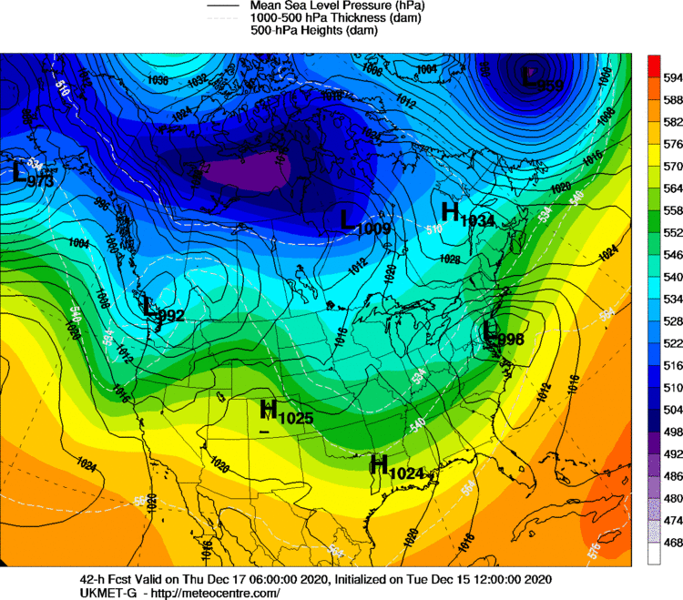
EURO went east, not sure what that means for totals but would limit the mixing issues in Lanco.
-
Through 24 looks pretty much the same.
-
-
1 minute ago, pasnownut said:
Yeah complaining about 6 vs 16 is probably not right, but I've been sucked in and see enough to see it in jeopardy. I'm not panicking. If I get a crap ton of sleet on top of 6-10 I'll be alright.
It's all good my friend. I get it, I got sucked in for over a foot but who knows. I'll be up all night tomorrow night. LOL. I have been up after 1am every night to catch the EURO. Good time for remote work.

-
1
-
-
1 minute ago, paweather5 said:
 ukie is ugly when does the west trend stop.
Nice.
-
1 minute ago, pasnownut said:
Euro will really tip the scales IMO.
Parsing over thermal profiles, we are still safe, although SE is marginally so for a few panels. Thats going over the 700's and 850's, so while best forcing may be NW, we may depend on rates prior to any changeover for eastern locals. Were on the edge, but still have a little buffer.
Things certainly got a little tighter right now down here. All I know is that is going to snow and it will be a winter wonderland for the first time since I can remember it.
-
7 minutes ago, pasnownut said:
CMC loves CTP, but tells me to get tissues ready. Tucked LP is undeniable on nooners. Still scratchin my head tho.
In summary of nooners...I have less confidence for mby, but think mag to hazelton and areas around are big winners of the 12 runs.
I agree to a certain extent, but think we are all winners whether it is 12" or 18" There may be a period down in Lancaster and York counties that flip for a bit, but I can't see it lasting long. EURO for run after run never shown mixing issues.
-
These models have been dialed in for days now more than ever. Now it is just time for the event to start. I haven't seen so much consistency in model run after model run at least for the state of PA.
-
1
-
-
Sweetness:

-
5 minutes ago, pasnownut said:
RGEM tucks into western bay. Waiting for panels, but CTP should be liking it. My nerves are about shot tho....lol
nice CCB signal as well. starting to see that again.
RGEM is a winner. Yes, some mixing occurs down in the southern counties on this model but it is very limited and back to snow. Similar to 1993? :-)
-
3 minutes ago, Atomixwx said:
Has der Ikon ever been right? Lol
No.
-
4 minutes ago, pasnownut said:
But DOOONNNT look at the panels that follow....YUUKK. This one will push people to the ledge. Just assume the germans are messing w/ our subforum. ITS UGLY.
It is the ICON, had to do it just once!
-
 1
1
-
-
-
8 minutes ago, Paleocene said:
Welp. Hope I see a bunch of sleet in Silver Spring before it changes to rain tomorrow afternoon. Good luck to the northern tier.

What map are you posting?

-
3 minutes ago, Atomixwx said:
I'm wondering if Lake Raystown would be the spot to see this go down at this point.
I don't think you would have to travel to see it go down at this point.
-
4 minutes ago, sauss06 said:
i hope you guys like what i'm giving you for Christmas. You can open your gift Thursday Morning.
Thanks for the Snowblower Sauss!
-
1
-
-
2 minutes ago, pasnownut said:
verbatim, no dry slot on 12k. Scratch that off "our" worry list. LP shift NE seemed to save us. I liked the subtle increase of CAD and hope that in the next couple runs we continue to see the HP in Quebec do its thingy to the LSV thermal profiles. Track really was nice, so I'm happy w/ that (and am cool w/ sleet in the mix - just not too much).
At the very least on the sleet changeover per model trends if it were to happen, very minimal and then back to all snow. We will see what the rest of the day brings.
-
2 minutes ago, pasnownut said:
In fairness, you can see at 45 the "dampening" in my area (Lanco). I looked S and SW of me to see the movement of the R/S line and I'm ok w/ what 12z did. It's first out of the nooner gate, and seemed to stop the westward progression of the LP
6z

12z

Agreed good comparison between 6z and 12z.
-
Just now, Itstrainingtime said:
You are correct.
However, the trend north and the band of heaviest snow has moved notably north as well. His concern at this point is valid. (still think his area is in a really good spot)
I think whatever/whoever changes over or mix of snow/sleet/FRZ rain is just for a small period of time based on the track of the low. It will not damper in snow totals all that much unless the model runs today continue to trend north and west further that even true Central PA gets into mixing. Highly doubt that.
-
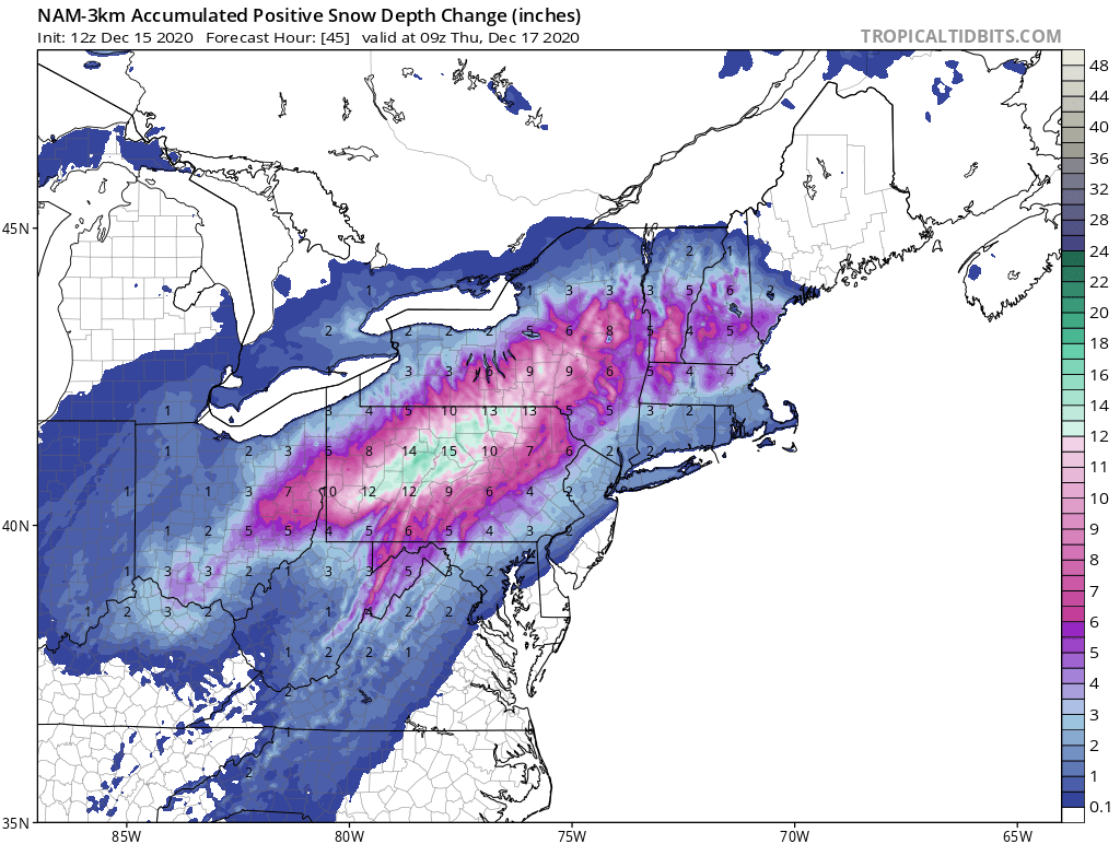
2 minutes ago, pasnownut said:
@42 LP 50 miles NW of 6z.
This is 42:

-
1
-
-
6 minutes ago, whiteout said:
Man really feel like this is slipping away for us in the LSV here the last 12 hours. First Euro jumped N with the best totals and judging by the NAM we may be in big trouble.
.If your in Shippensburg I am not sure what is slipping away from you. It does appear on the NAM that Lancaster county is at risk to turn to sleet/FRZ rain for a period of time.

Central PA - Winter 2020/2021
in Upstate New York/Pennsylvania
Posted
No more snow showers.