

paweather
-
Posts
10,339 -
Joined
-
Last visited
Content Type
Profiles
Blogs
Forums
American Weather
Media Demo
Store
Gallery
Posts posted by paweather
-
-
GFS = sorry. You can look at Canada and it is writing on the wall.
-
the first weak storm became a convoluted mess.
-
6 minutes ago, bubbler86 said:
Yea I was speaking for Pitt specifically.
yeah saw that sorry.
-
and it is the icon hug the NAM. :-)
-
Just now, bubbler86 said:
Not what you wanted to see unfortunately

that's not bad though.
-
Just now, 2001kx said:
fingers crossed!
For you me too! You are looking good.
-
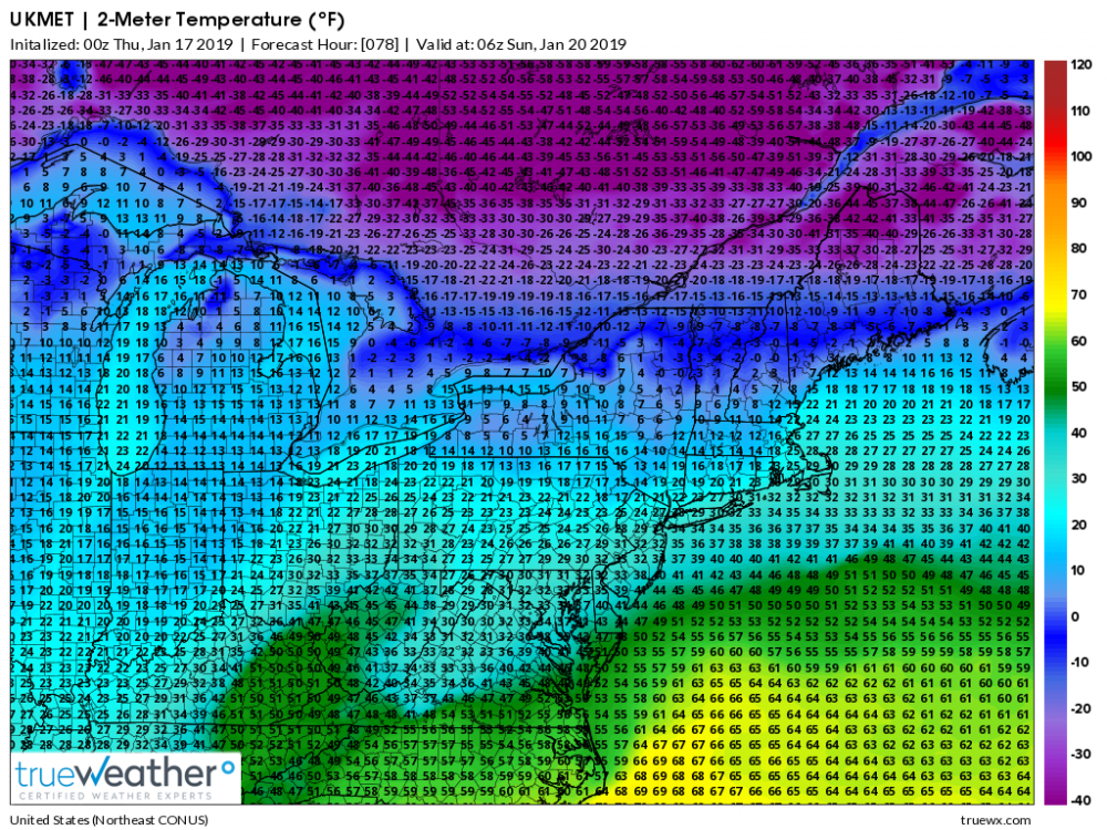
Per EC 0z 2M temps below 32 and in the mid 20's through 18z Sunday (1pm) lots of ice for us. back to snow.
-
1 minute ago, daxx said:
Yes
DAXX Thank you man.
-
Just now, 2001kx said:
Im no Met but that looks good for C-Pa to my eyes.
yep. You got it. Good luck things are falling into place. Your in a good location. 12" plus. < less than 12 to 8" no rainstorm that is for sure for us here.
-
2 minutes ago, daxx said:
Damn cold Monday morning! Has most of us below zero!
below zero down here. :-)
-
Williamsport, dude. get your shovel ready. This is going to be one of a historic storm. I still think it will come in colder for LSV lots of cold air. Lots of sleet/FR rain. Pretty much we get a great thump to start. 8-12" LSV is my call. and yes, Horst I know you can prove me wrong but model trends are trends. See you tomorrow folks.
-
Pummeled before we change over:
.thumb.png.803ef9785c5ca1f5f60301ae41e5707f.png.a5feb5293206d540a645381fbb8b8fed.png)
-
Just now, Stormlover74 said:
Not quite Pittsburgh but northern WV
and it doesn't transfer it just heads east. This is what you want up in NYC. That is why you see the snow totals.
-
OK Here we go EURO. I will try to maneuver through the other forums.
-
1 minute ago, 2001kx said:
LOL. haven't seen his name in a long time. I don't know what to think.
-
Just now, USCG RS said:
Im saying it's a model depiction. I believe thr Ukie has the right idea but it's not there yet. I don't believe this is a transfer situation.
Sent from my SM-N960U using Tapatalk
Thank you. it is a low moving east based on the boundary. We all need that boundary to setup to the south. All you need to do when a model runs is look at Canada.
-
 1
1
-
-
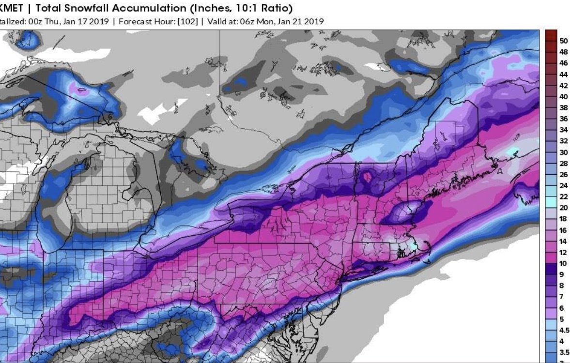
I really think we need a new thread for this weekend. 1-3" tomorrow night and Friday and then our weekend storm.
-
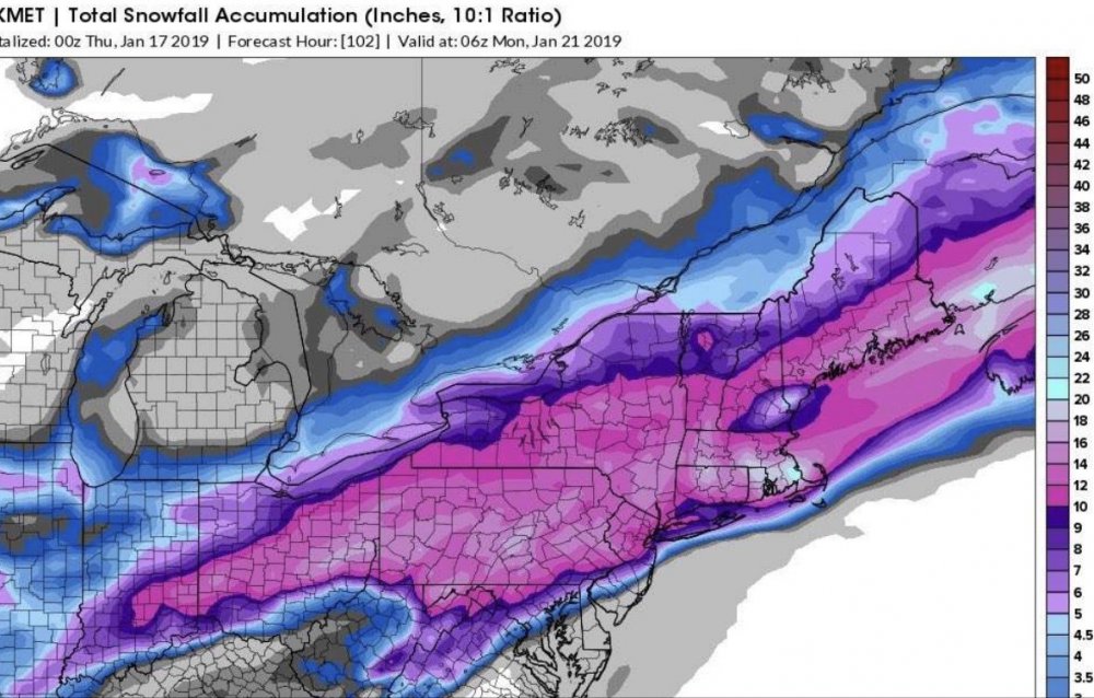
Just now, Blizzard of 93 said:
That is a beautiful UKMET map !!! Wow!
Yep. Let's go Euro.
-
2 minutes ago, USCG RS said:
Yeah. I'm guilty of this here. I didn't look at the LP in the frame before it scoots to the delmarva
Sent from my SM-N960U using Tapatalk
yes you are correct there is no miller B at all. There is no secondary. Good work. It is a matter of if the HP is strong enough to suppress it to our south. UKMET shows that.
-
This is hardly a miller b scenario.
-
Gosh these other sub forums LOL. Primary to Pittsburgh? I love it.
-
-
1 minute ago, paweather5 said:
Nice!
-
Well I was sucked in, didn't think I would stay up for the EURO. Anyone here have PBP and again thank you DAXX for last night being on vacation. If not I will go to NYC forum who is still talking about Hurricane Sandy :-)

Central PA - Winter 2018-19
in Upstate New York/Pennsylvania
Posted
Toast but nice front end thump om the GFS so close though...……..this is going to be a rollercoaster the next couple of days.