

paweather
-
Posts
11,418 -
Joined
-
Last visited
Content Type
Profiles
Blogs
Forums
American Weather
Media Demo
Store
Gallery
Posts posted by paweather
-
-
39 minutes ago, MAG5035 said:
Generally in agreement here. While not completely flipping the EPO, ensembles have been at least neutralizing it some as it's gotten out past next week. It's a key thing to happen, because we do have an issue of source region of cold initially which likely manifests in the coastal later this week probably not getting cold enough at the low levels for much snow in PA (more likely toward interior NY/New England) and probably the next system of note that comes about later next week. But you can see it on the models.. once they build any semblance of higher heights on/just off the west coast, it's enough to get the eastern US right where we want it. With that block over the top, we don't really need a raging -EPO ridge to succeed (though an EPO ridge would be nice). We just need to tone down the Pac jet enough as to not flood the CONUS with Pacific air under this awesome block we have materializing in the NAO/AO realm. I'm pretty confident were going to get there.. it just might be around week 2 of Jan or so where we really start seeing this.
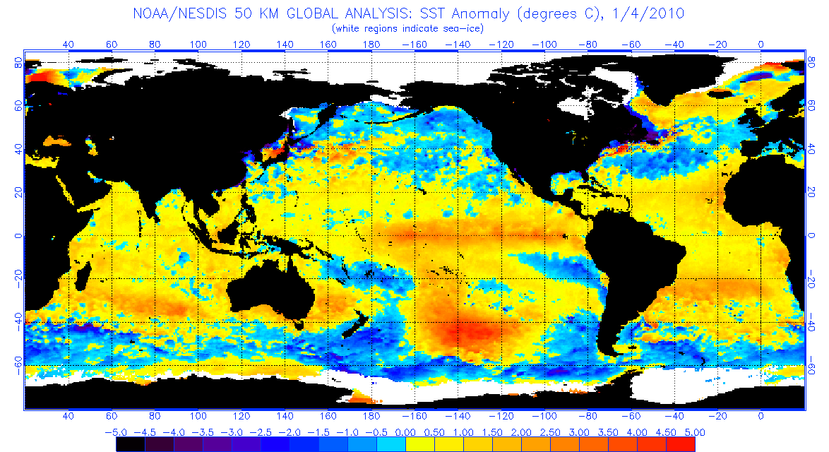
The 09/10 comparison is relevant here.. simply because we haven't seen that kind of a strong and stable NAO/AO blocking regime since 09/10 and the early part of the 10/11 winter. What I'm curious to see is where the obvious differences between this winter and that winter take us. Of course the big difference is we're working a solid La Nina vs 09/10's solid Nino. The other thing is the SST anomalies in the north Pacific. I was going to post about this earlier in the month, but then the big snowstorm showed up and that was the big topic. But pretty much when comparing past Nina's of the last 25 years+, you won't find one with the + anomalies in the N Pacific that this one has. Most of them are quite cold there. The most recent Nina in 2017-18 is about the closest comparison but still had more colder water.
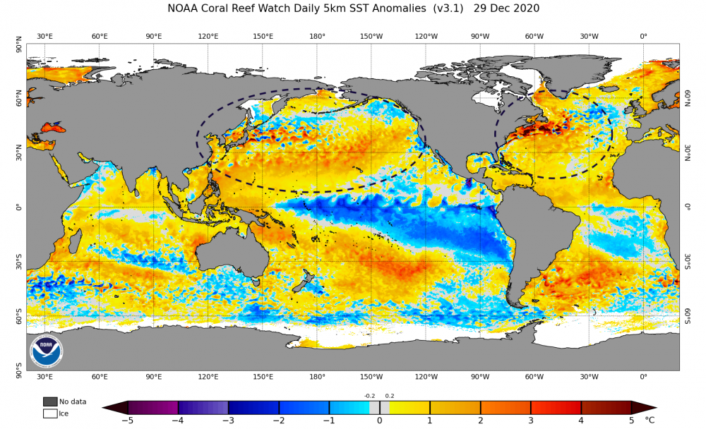
My big worry initially when seeing anomalies like this going into the winter was the assumption of not much help from the NAO/AO and seeing hostile teleconnections from the Pac side materialize. One could see the potential torch in the making. The blocking is a game changer, and now suddenly one can see the potential from an active pattern and suppressed storm track from the blocking. Back to 09-10, here's what that looked like at this point.
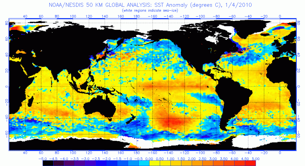
The Atlantic and the Gulf of Mexico got even colder with respect to average when February rolled around. But yea, huge difference in SST makeup. I tend to suspect that the much warmer N Atlantic this year might help keep a tighter storm track to the coast and you might not see quite the suppression you saw in the 09-10 winter, which was certainly less memorable in New England.. or Williamsport for that matter if we're talking about this particular subforum haha. There were some folks in here that got next to nothing from Feb 5-6, 2010. It's going to be interesting to see how all this shakes out going through January. If we hang onto the -NAO/AO regime we're definitely going to have chances.
Thanks Mag! Great write ups both of you.
-
 1
1
-
-
2 hours ago, showmethesnow said:
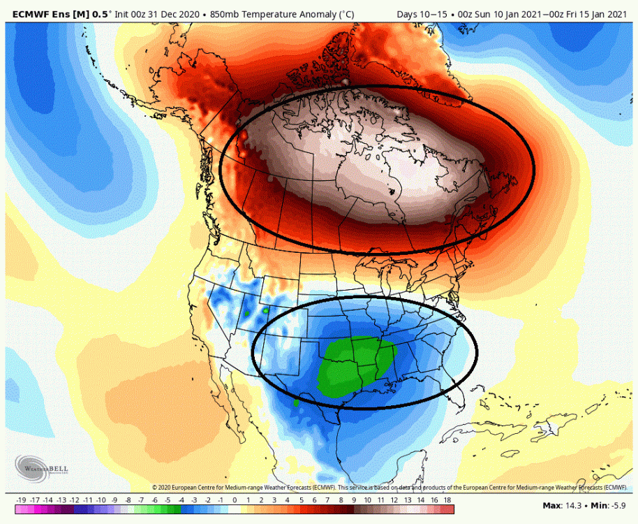
Admittedly my excitement level has increased this last week after each day of runs. But last night's run of the EPS has me over the moon. And the EPS is not on an island as both the GEFS and the CMC are extremely similar.
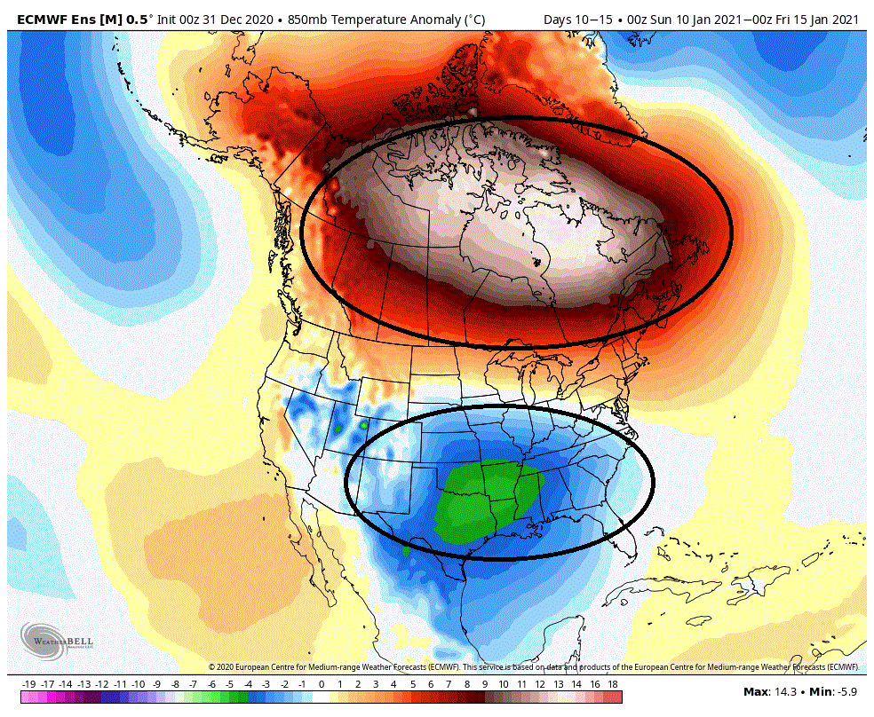
When I see this, the whole of Canada torching with cold anomalies under riding it through almost the whole of the CONUS...
And please, no references to how this sucks because our source region for cold air is on fire. Doesn't matter here.
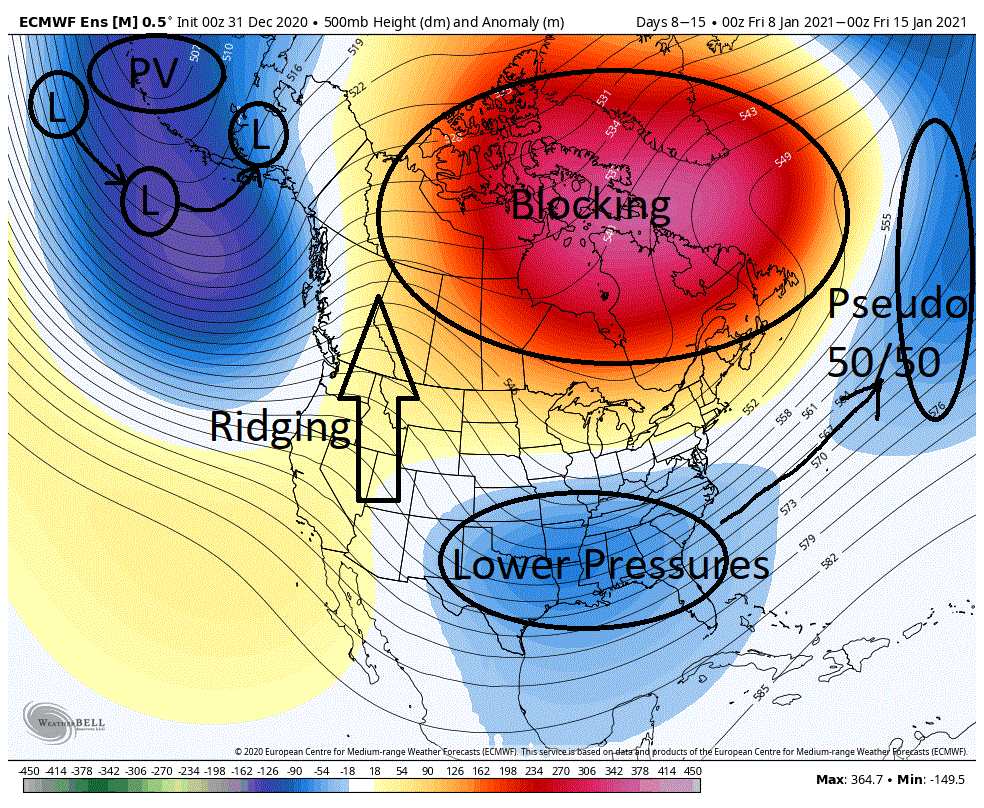
Then I see this... The PAC firehouse which has been blasting the west coast and overwhelming the flow through the CONUS is pulling westward and weakening in the extended. And the southern/subtropical jet, which has been active, is now aligning up and off the east coast and planting around day 10 in a very favorable local, all the while strengthening as we move forward in time.
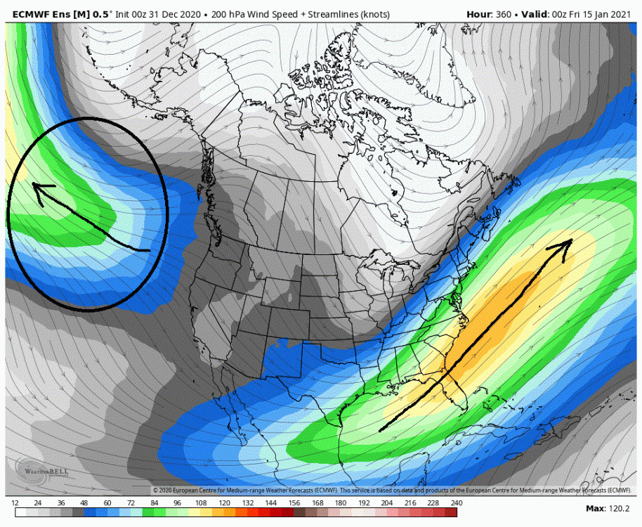
The two maps portend well for what we would actually see at 500 mbs. And they did not disappoint. I think we would be hard pressed to find a better look then what the EPS (and other models) are now throwing out. This is a seven day mean from day 8 to 15. As we can see there is massive blocking now projected over almost all of Canada. This will tend to force the storm track farther south through the CONUS. If you look over Alaska and was hinted at by the PAC jet, we see that the PV has shifted west so subsequently energy/storms revolving around it have shifted west as well. This is a favorable local as it will help to pump up heights in western Canada. In the western CONUS we now have ridging/higher heights from subtropical regions extending all the way up into Canada. The importance of this is twofold. It sets up a delivery of cold air into the central US which will be pushed eastward underneath the blocking through Canada. It also is playing a part in bumping up the southern jet from the Gulf and up the East coast which provides moisture as well as potentially injecting southern stream energy into any potential storm. As you can see, we have lower pressures over the southern states and the Gulf and it is exactly where we want to see them. If you note they are extending eastward trying to connect with lower pressures in the north Atlantic. This is a signature look for storminess in the east. You may say the lower pressures (pseudo 50/50) in the N-Atlantic are too far to the south and east for our needs. But no, in this case they are exactly where we want to see them when considering the given projected pattern. Now when it comes to snow there is always a degree of luck involved in the East. But really, this is a winning look for our chances. It doesn't get much better then this.
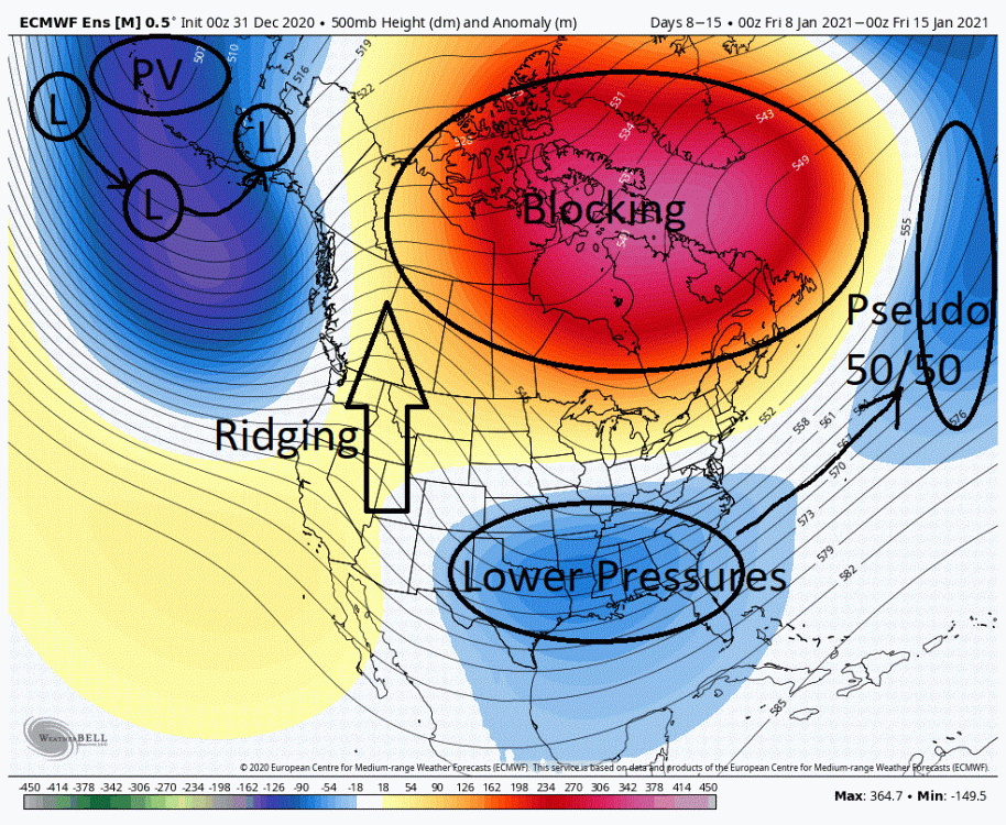
If it wasn't exciting enough to see the above for the day 8 to 15 period, what really should excite you is that this will more then likely be a very stable pattern. This is a pattern that could potentially last for quite an extended period of time. So what would I expect given the above? In my opinion this argues for the axis of heaviest snow being centered around the mid-Atlantic. Somewhere between New York city down to Richmond. This could very well be a case where those in NE are smoking cirrus time and again, especially away from the coast, and those in DC/Balt/Philly are exhausted from shoveling 1-2+ feet of snow time and again.
Now some people throw out comparisons to glorious previous winters at the drop of the hat. I don't. I believe that each winter is unique in its own way. So though there may be similarities there are also differences. Differences that can have a big say on the final outcome. That said, the similarities we are now seeing are striking to a previous winter. Dare I say 09/10?
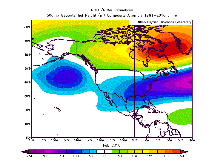
Below we have the mean for the month of Feb 2010. I want you to compare this to the above 7 day mean from the EPS. They are eerily similar. Now some may look at the lower pressure anomalies on the 7 day mean above and say it doesn't quite match up to Feb 2010. Let me just say, if we were to run that 7 day mean forward for another 2 1/2 weeks (to give us a full month) I would put good money that this is the look (lower pressures in the east and off the coast) we would end up with as the storminess kicked in.
Now there is always a degree of luck involved when it comes to snow. But if the above projected pattern is in fact what we see, I very much like our chances as we are rolling with the equivalent of loaded dice that come up 7's almost every time.
Excitement thanks for the post.
-
1
-
-
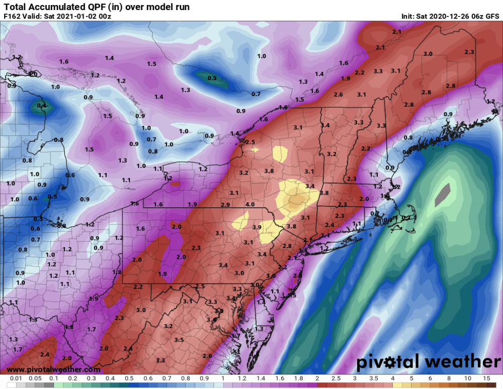
Happy Hour bringing back the January 3rd idea of course too warm right now:

-
5 hours ago, Ruin said:
I so dont like Ice i can take sleet but frz rain yuck
GFS model has backed off a bit for SCPA on the ice threat 0z and 6z both show the high to the north being pushed out quicker. We will see what today brings.
-
Interesting a little Ice Storm on New Years:

-
10 hours ago, Blizzard of 93 said:
The 0z GFS & Canadian agree with the concern of a messy mix event possibility this coming weekend. The Euro also has it, but to a lesser extent. It will depend on the strength of the High to determine how much mixing CTP would get and the duration before changing to rain.


Thanks Bliz and Mag I was really hoping there would have been something to track over the holidays.
-
11 minutes ago, paweather5 said:
In a big way on the gfs. Wonder how the River will handle this.
It should be interesting after Thursday’s rain.
-
1
-
-
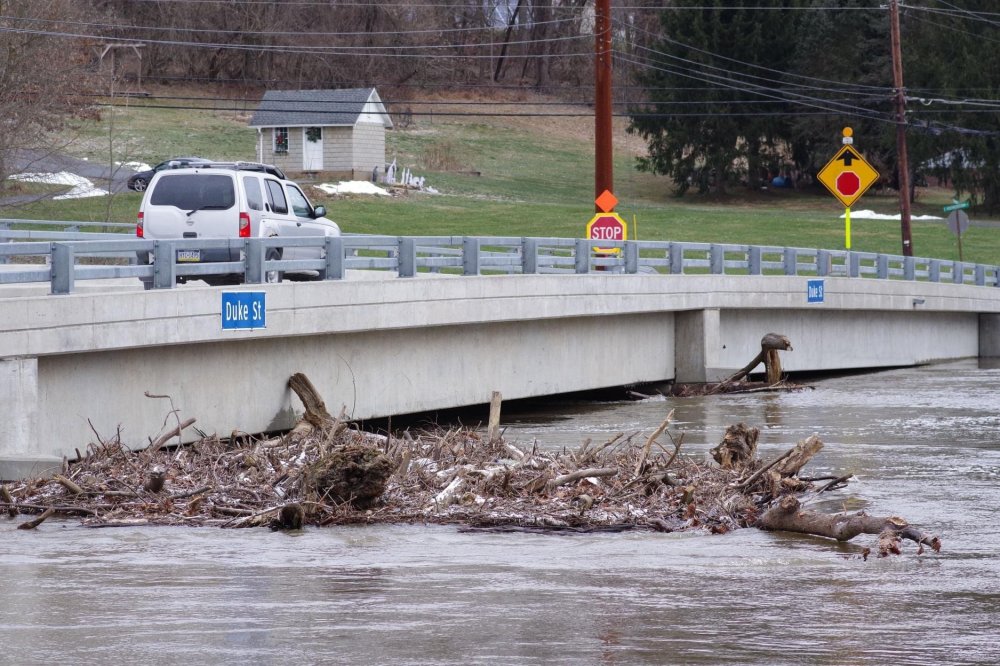
Swatara Creek near Hershey this morning:
-
2
-
-
Looks like a repeat from Christmas Eve on NYE.
-
Wow!!! What a surprise.
-
3 hours ago, Blizzard of 93 said:
Merry Christmas everyone!
The Euro Weeklies last night keep the -NAO pattern going until late January. We should get snow chances in this pattern.
I saw recently that @psuhoffman claimed the period from January 5th to the 15th as the window to watch for winter storm chances for our region.
Our time will come if this type of pattern persists for several weeks. We just need to be patient!


Thanks Blizz! Let’s hope.
-
1
-
-
Puking snow! Oh dang sorry rain

-
39 minutes ago, dcfox1 said:
Seems like the heavy rain has been in upper sus valley and NY state where they had the most snow. All that is coming down here to LSV. It would be much worse if not for the low river levels. Not related but what was the year of the big Ice storm 8 or so years ago. I lost power for 2 1/2 day.
Agreed. This front is hardly making it to the east all day with a surge of moisture continuing to come up from the south.
-
Just now, canderson said:
It’s currently at around 3.5’ - quite insane indeed.
Just plain crazy. Hope you make out OK!
-
16 minutes ago, canderson said:
Predictions have the Susquehanna in Harrisburg reaching 19’ Saturday - that’s moderate flooding here. Basements impacted mostly.
That is insane given how low the river has been. The stream of moisture fetch from the gulf up to the East Coast is also insane.
-
Merry Christmas, Everyone! Let’s hope for a Xmas gift in the word of snow the next couple of weeks.
-
 1
1
-
-
26 minutes ago, CoralRed said:
I know you are all thinking snow. I am here in Williamsport trying not to think of the mess we will get from 25" of snow that is mostly still here, temperatures in the 50s, several inches of rain and a Christmas Day refreeze. I can't think of the last time something like this happened. This is quite a collection of extremes.
It’s called 2020.

-
1
-
-
5 minutes ago, pasnownut said:
I'm sure many (myself included), would love nothing more that to turn a cannon onto 2020 no matter what happens next week.
I CANT WAIT to turn the calendar..but yeah some snow to end it on a better note would be great.
Yep your exactly right about that! No matter what happens bring on 2021!
-
Let's hope next week brings a snow bang to 2020.
-
1
-
-
2 minutes ago, Itstrainingtime said:
WPC "Loves" the Poconos for the rainy bullseye (see what I did there :))
That is a nice heart.
-
1
-
-
5 minutes ago, kerplunk said:
Lots of uncertainty with this system concerning rain to snow. Still hoping for decent back end snow here. One thing for sure is it’s going to get COLD.
Yeah, we don't usually do well with post frontal snow even if it is modeled. Lots of rain for sure.
-
This artic front has been modeled for days since last week, this means business going to bring Christmas in with a bang both a lot of rain and maybe some snow on the backside.
-
2 minutes ago, Itstrainingtime said:
I would think that this would set the stage for what might happen thereafter.
Yeah, Even this 999 Low off the coast doesn't match the precip shield you think it would have and cold air available that is why I posted it.
-


Central PA - Winter 2020/2021
in Upstate New York/Pennsylvania
Posted
Mid month on the 12z GFS has an interesting evolution. It is a long way away but that is when I think PSUHoffman was also talking about (with the Mag and Showme posts today) the pattern kicking in ripe through February.