

paweather
-
Posts
11,418 -
Joined
-
Last visited
Content Type
Profiles
Blogs
Forums
American Weather
Media Demo
Store
Gallery
Posts posted by paweather
-
-
2 minutes ago, Blizzard of 93 said:
The ICON has a nice track that stalls out off of the DE & south NJ coast.
It has a nice swath of heavy precip over CTP.


Blizz get on the phone with our local stations.
-
Just now, Itstrainingtime said:
It's Wednesday. There is plenty of time for him to slowly ramp up wording and amounts. I'd rather that than go big now and have to keep backpeddling.
He could at least mention the possibility of a major storm, perhaps he has said that...
Exactly. Just comment on it or some phrase he could say instead of downplaying.
-
 1
1
-
-
I guess they don't look at the models other than there own. ICON. Again very consistent.

-
Just now, Atomixwx said:
WGAL also taking this stance.
Good for them use to love Joe Calhoun. I miss Matt Moore.
-
Best post from PSU tonight:
1996 tucked

1/25/2000 tucked

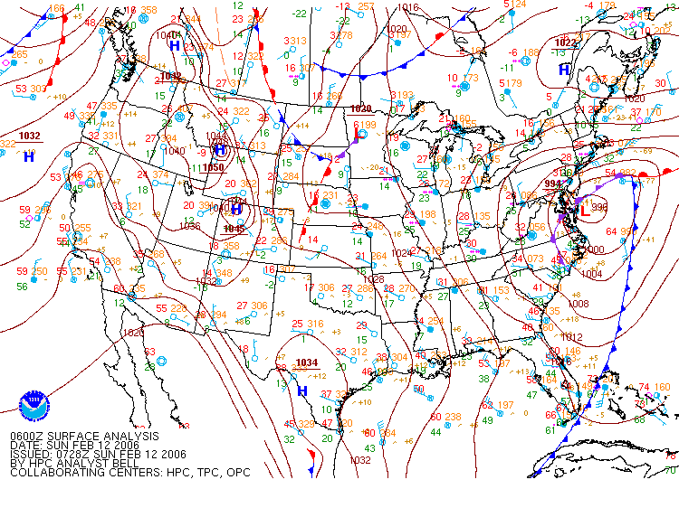
2/12/2006 tucked
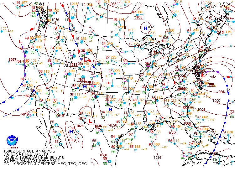
Feb 6 2010 Tucked
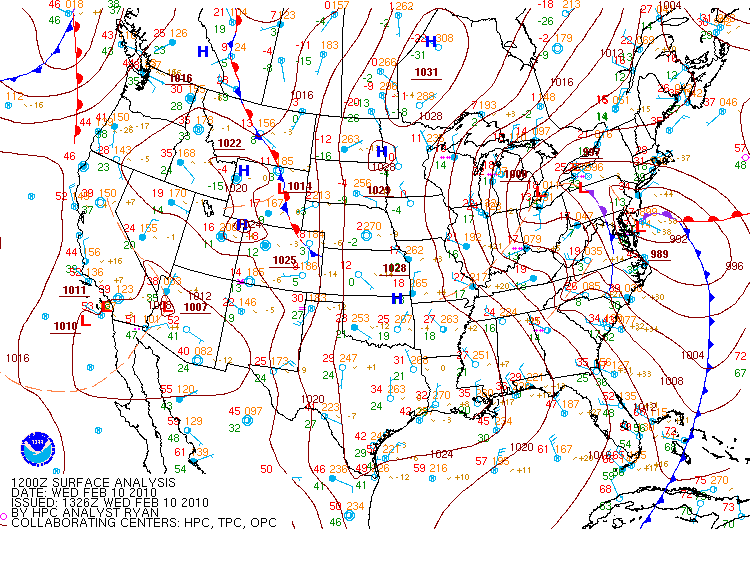
Feb 11 2010 tucked
Feb 13 2014 Tucked
2016 Tucked

Almost every one of our best snowstorms of the last 30 years was tucked in right against the Delmarva coast. The only exceptions were Dec 2009 and Feb 2003. 2009 managed that because it was a very amplified stj wave out of the gulf with an amazing moisture fetch that was 985mb over eastern NC It also had an inverted trough into WV so that combo meant an incredibly expansive heavy precip shield to the northwest of the track. It tracked NE from the outer banks. Frankly a less intense and less juiced up STJ system with that track likely doesn’t provide big totals in the NW 1/3 of our region normally. That track would usually fringe places like Winchester or Hagerstown or Frederick. PD2 was a west to east STJ wave overrunning an Arctic high. The coastal was weak sauce here and had very little contribution to that event. But the rule on an HECS here is we want the low tucked into the Delmarva coast.
-
1
-
 1
1
-
-
Just now, Atomixwx said:
Yes but inciting panic buying at Giant also is not their job. He may be basing his forecast or projection off of experience or climo or any other number of things.
I'm not saying inciting panic at all still early. Just do his Job and tell the truth. Nothing is set in stone but to downplay it right now he is doing the opposite of good weather media reporting. We know more than him.
-
Just now, anotherman said:
I think he’s basing that forecast on some in-house model. It’s the only thing that makes sense.Any local weather person to downplaying event right now it just wrong. It may end up going the wrong way and he would be right but every model shows a strong signal of a significant winter storm event.
-
Is this the EE rule for the NAM/EURO? or maybe the weekend rule.
-
Incoming 0z NAM:

-
1
-
-
I'm staying up tonight. At least for how long I can. Tom Russell. LOL.
-
Not total shit but again in a different camp. Give us more snow then last year alone.

-
18z still shows a strong backend thump as well.
-
I competition of 2 model camps even though we still get a good thump with the Primary. GFS and EURO/CMC are so different.
-
18z ICON was pretty good, OK GFS let's not disappoint.
-
Just now, Bubbler86 said:
I am usually not so easy on them but hard to fault anyone with not having real practice time and so many injuries this year. The one thing I think we learned is that Tom Brady is fairly amazing.
No doubt.
-
1
-
-
3 minutes ago, Bubbler86 said:
Thanks. I am just glad you kept your America Team icon.
HAHA. Well that was a tough one this year.
-
We are closing in on the NAM'S RANGE lol. Not quite but we have the 84hr look to enjoy.
-
9 minutes ago, Superstorm said:
Love that EPS mean.
.This!

-
22 minutes ago, Wmsptwx said:
Never trust a Miller B lol.
I agree this is going to be a nail biter right up to when it starts. I feel like we are going to have a swing down on the models for maybe one run or so. But the good news is if we can get a good initial thump from the Primary and the transfer doesn't go well we still win.
-
1
-
-
2 minutes ago, Ahoff said:
Ugly hole in Pittsburgh, but moving towards a better solution.
Yeah EURO/CMC dies the primary early and transfers. Whereas the GFS keeps the Primary alive longer where you would have a better shot to up those totals.
-
4 minutes ago, Bubbler86 said:
All the markings of an LSV crusher (AKA Cashtown Crusher). Probably been since 2016 that we have had a SLP redevelop in the SE and move almost due north into cold air. Regardless of model output the place to be for that Euro storm is the S/E one third of PA. Stalls, double barrel looks, retrograding....
As others said good to see you back.
-
MA is crashing the board.

-
1
-
-
And still not done:

-
1
-
 1
1
-
-
Just now, pasnownut said:
Its a doozy. Someone post perty snow pics.
BTW, it is really really close to CMC (if one toggles bak n forth).
Going to buy more chips....the hand is hot.
It is still snowing at 150.


Central PA - Winter 2020/2021
in Upstate New York/Pennsylvania
Posted
Unbelievable same evolution on the GFS.