

paweather
-
Posts
11,418 -
Joined
-
Last visited
Content Type
Profiles
Blogs
Forums
American Weather
Media Demo
Store
Gallery
Posts posted by paweather
-
-
Just now, Bubbler86 said:
Snow always seems to be more blue on the Nam maps via TT. Not sure why....just a coloring oddity I guess.
It's a tease. LOL.
-
If this doesn't explode.
-
NAM is looking good to start.
-
1 minute ago, MAG5035 said:
This is going to have a nice snowfall swath but I don't think this is going to have the high top end potential of the December system. With that said, we're getting pretty close to meso range and it's likely there's going to be some imbedded meso features in this precip shield that show up and probably bolster some totals.
I'm liking a general 8-14" where the handoff pivots the precip shield without slotting, which I think at the moment roughly favors the southern tier east of US 219 and from US 22 and south down into the I-70 corridor in Northern MD. 4-8" is between that and I-80 and 2-5" above, with the lower side of the range NE PA. I think all of SW PA below I-80 could see a 4-8" type event if there's no mixing issues, which models have been bringing that primary south some. That would basically be how I'd draw my snowmap at the moment if I were to do so.
Could there be bigger totals? Yea, but I think it stays under 20".
Thanks Mag for your thoughts.
-
Not an EPS guy but I had to steal this, don't tell the cops:

-
Well we always have the NAM coming up to start HH. Cheers to good Friday HH runs.
-
1 minute ago, canderson said:
If I get 6” out of this I’ll be pleased. Less I’ll be sad but not really mad. More I’ll be ecstatic But half a foot seems reasonable.
I agree with this. I set my bar too high seeing the big totals earlier on the models. But everything is still in play and will be until game time. Models will likely be all over the place especially with Miller B's. It could be a monster hit, to a medium 6-8" hit, to a bust. If it is a car topper please band me canderson.

-
Just now, sauss06 said:
id like to see it snow through Monday around noon please.
When we had those earlier Model runs it was snowing into Tuesday. The one other trend we are seeing in with the models is no mixing issues in S PA like they were showing in earlier runs.
-
 1
1
-
-
1 minute ago, pasnownut said:
and if your confluence concern eases a tad bit more, that hole might fill w/ more fluffy stuff. Even most souther solutions still correct north a bit before go time. That in itself might bring forum back to life.
We just need the tuck rule for this to be a long duration those model runs earlier really spoiled me with what looked like a coastal stall around the benchmark.
-
1 minute ago, MAG5035 said:
Welcome back to C-PA, Euro.
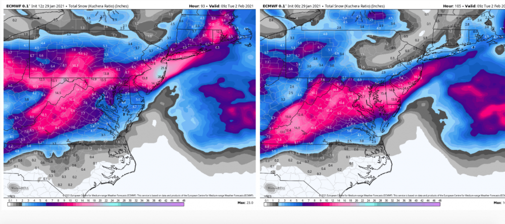
WOW. Insane. The 12z runs today not bad at all.
-
Not bad, not the monster but better than 0z:

-
1
-
-
South trend is over at least for now.
-
-
Me thinks this is going to be good.
-
1
-
-
1 minute ago, Atomixwx said:
I'm basically at the point where I'm holding my chips and determining whether or not it's time to cut my losses and cash out and drown my sorrows in strawberry syrup at IHOP or go all-in like somebody whose about to punch out his wife because the lights are turned off.
You got to know when to hold 'em, know when to fold 'em
Know when to walk away and know when to run
You never count your money when you're sittin' at the table
There'll be time enough for countin' when the dealin's done -
Primary seems south at 54.
-
Yep already out to 48. Light snow in the burg 7am Sunday.
-
18 minutes ago, sauss06 said:
all my calories are saved for beer bro, you know this!
I thought we were having a snowfall pool? and where's FHS, anyone???
Now you tell the truth! Where I have been drinking for 30 years! FHS is getting bread and milk right now.
-
1
-
-
Cheer up time.

-
Just now, pasnownut said:
supposed to, but was held up due to some tweaks that were needed.
Whatever tweaks needed I think it worked today, IMPLEMENT IT.
-
2
-
 1
1
-
-
Just now, sauss06 said:
If i get a car topper, i may take up drinking
hmmmm........That won't work for me. LOL. Just a JI ban will do it.
-
1
-
-
2 minutes ago, pasnownut said:
dude, all good and why we are here. Point/counterpoint is how we learn and what makes this sport fun.
No need to explain....I'm not easily offended. I totally get your point. I'm just doing the same from a different lens.
If I'm wrong, I'll eat crow the same way I last did. Eat the feathers and throw the meat.

I agree, Point and Counterpoints are all good. It is all healthy discussions. But if I get a car topper on Sunday someone may have to ban me.
-
1
-
-
Just now, pasnownut said:
So he's basically as divided/unsure as we are.....
awesome!!
HAHA. I think everyone is unsure of this storm, no doubt.
-
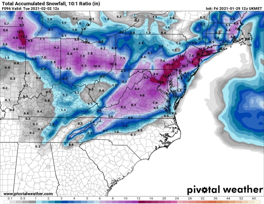
1 minute ago, canderson said:
Here's the 12z Ukie, stolen from the MA thread.

Not bad.


Central PA - Winter 2020/2021
in Upstate New York/Pennsylvania
Posted
Primary down in W NC?