

paweather
-
Posts
10,467 -
Joined
-
Last visited
Content Type
Profiles
Blogs
Forums
American Weather
Media Demo
Store
Gallery
Posts posted by paweather
-
-
15 hours ago, Blizzard of 93 said:
Welcome back! I like your Winter thoughts as well!
Yes welcome back! It was great to see wintry precip this morning!
-
3 minutes ago, pasnownut said:
you missed this one. Yes its only 1 frame that we lose thermals, as 850s crash in the next, but SE crew would turn/taint for sure. Regardless, we are parsing over an Op run in wayoutthereland, so not really worried, as we'll have 20 more looks to pick from in the next 10 days, but like i said, its close enough for me to push SOME house money in.

Yep and agreed, house money time since we really have nothing else to look at on these model runs might as well do it.
-
2 minutes ago, pasnownut said:
Not a cutter but looks like a killer B to me...
Closed countours of the SE coast show Coastal transfer complete in following 2 frames and verbatim, saves the 80 north crew, but yeah, i'd take that early on and be happy for the northern crew.
Sign here ___________Nut______________________
Yeah, the next frame has it is off the coast of the Delmarva. 540 line is still to our south though. Good position to be in for all of PA. Until the Happy Hour Run. :-)
-
Is this the timeframe we are looking at, could be? This is not a cutter.

-
GOSH! 992 L in this position where is January!

-
16 minutes ago, Itstrainingtime said:
A light wintry mix of rain and sleet continues here. 42 degrees.
Nice. I just have some light rain.
-
2 minutes ago, Itstrainingtime said:
Ji is off-putting to a LOT of people on here, and I totally respect those that feel that way. Personally, I think he's the funniest negative person on the board. His act does grow a bit weary to me only in that he actually knows a lot - I listen to what he says because honestly...he's often right.
I agree, I like him honestly and he has so much passion for winter weather like us.
-
Just went and got my fix on the Mid-ATL forum, I see DT is back posting on it. :-) I didn't see Bob but PSU is still posting over there. If you want doom and gloom JI is still on the board there.
-
Just now, Voyager said:
Since Hurricane Isaias it seemed as if most major events hit SEPA up to the Lehigh Valley. I wonder if that is going to be the predominant pattern through the winter.
I don't know, but could be. (I hope not for all winter if it setups that way)
-
And GFS is pretty much bone dry after this weekend, come on EURO helps us want to track something.
-
Glad this wasn't a winter storm at least on the 12z GFS it went south today with the low. Maybe now a half inch of rain for my area.
-
28 minutes ago, Voyager said:
Ha...anything generally east of the Hudson is game on with that run.
Just to let everyone know, I've been cleared for work, so let the job hunt begin.
Congrats!
-
 1
1
-
-
New England fun this weekend:

-
Nice start to the Winter Thread for 20-21!
-
Even though no snow here it is a winter type of day and feel outside.
-
Thanks Mag!!!!
-
Western and NW PA getting crushed today. Jealous!
-
1 hour ago, Superstorm said:
That weekend storm is close on GFS.
.Yes it is, then this one way out of course but:

-
25 minutes ago, Itstrainingtime said:
Just realized that I'm under a slight risk for severe this afternoon. In the meantime, a large area of moderate to heavy rain is moving in from the south now.
The day reminds me of a snow day how dark it is but it is a thunderstorm day!
-
Tomorrow is time to do a new thread so I’ll let the lucky one put it out there! Not me.
-
16 minutes ago, Wmsptwx said:
How much rain are we looking at tomorrow?
Looks like 1-2”
-
It could be starting in the SE:
-
 2
2
-
-
12 hours ago, MAG5035 said:
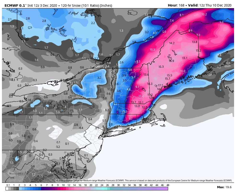
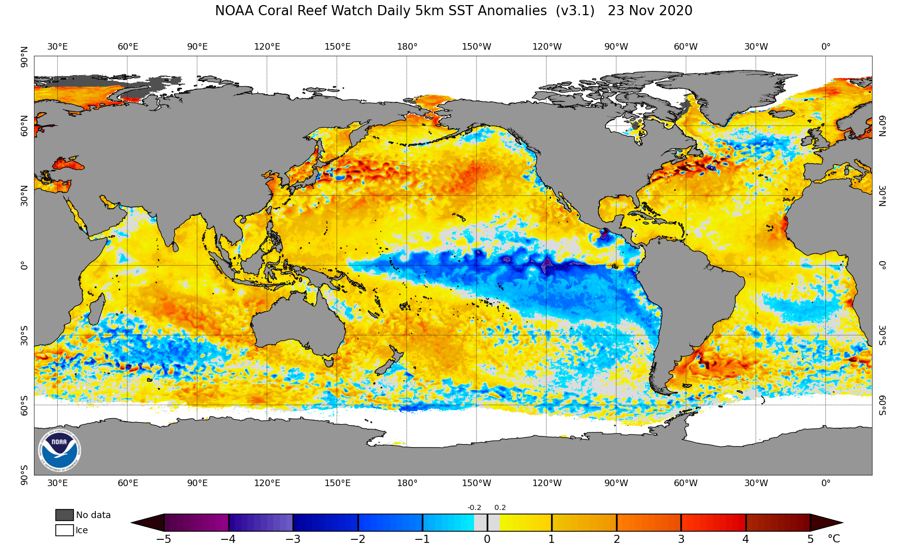
Trying to catch up here, I have been wanting to make a fuller post on the state of things and some of my thoughts on what this winter might do. @Blizzard of 93, I think this upcoming pattern presents a window of opportunity to get on the board with a more widespread event at some point during the front half of the month. Models seem to be zeroing a bit timing wise on the next major system around Mon/Tues. Really this is the first big storm of the fall/winter on the progs for the eastern half of the US that wasn't tropical or tropical influenced. Likely heading to the lakes as I don't feel we're established quite yet with the pattern/cold air regime that we need. Additionally, models (Euro/GFS) seem to be supporting early phasing of shortwaves as well, so the business end of this storm system up front is likely a pretty good rain event (which also isn't a bad thing in terms of drought relief). Now the 12z Canadian was interesting as it seemed to to be a bit east with the positioning of features, allowing a phase and deep low up into eastern PA and then NY State. That would put the western half of PA in the game. Lots of high heights up top keep the system from just shooting out and all guidance closes off the system, which depending on positioning of the features (surface low/500 low/etc) could dictate where some backlash snows and/or lake effect and upslope occurs. Somewhat more progressive could get us in a better position but I lean more towards this system being the one that could set the pattern up for the next one to have a much better shot. 12z Euro hints at that somewhat with a follow up wave late next week. Overall, that would be something I would keep an eye on as this week rolls along.. could be a bigger surface wave as depicted with that or perhaps a weaker wave that presents a lighter, but widespread event. We should hold in at least seasonable cold beyond Tues/Wed. It doesn't look like an in and out type deal like our cold shots have been to this point. Teleconnections show a nice +PNA to develop with NAO/AO at least neutralizing after a bit of a surge positive the next few days. Perhaps of almost as big of importance as the +PNA is the MJO progged to stay in the circle.. with esp the ECMWF forecast variations keeping it buried there for awhile.
So trying to blend this post into the bigger picture part of the equation..
@2001kx, I was looking into his 2020 wintercast online since I didn't see it the day it was on TV. Generally I agree with his numbers and he's got the standard boilerplate Nina type influences (lots of storms cut west/mixing systems, changeable temps, etc). The last winter post I made awhile back I mentioned that I felt snow totals would be perhaps 75%-ish for pretty much all of us with the Laurels region perhaps seeing the best shot at an average season. So yea, agreed there.. but I def don't agree or understand how he's coming to that conclusion from an analog standpoint. Says his top analog is 2015-2016. What? That winter was a record breaking NINO when we're coming into this winter at a solid NINA. I don't know if he's referencing some other factor when it comes to using that as a top analog but ENSO is one of the biggest influences (especially when they're moderate/strong).. so I def wouldn't be using that.
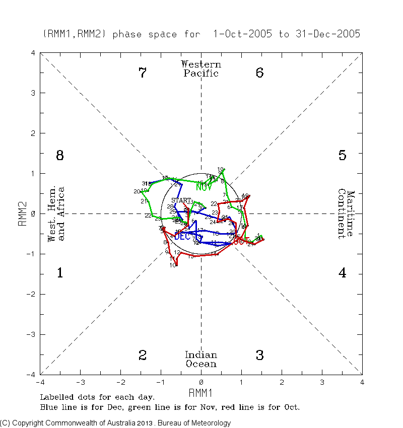
Even though the Nina is somewhat less than the current one, 2005-2006 should probably get a look as an analog. The hyperactive tropical season that also lasted late is the obvious similarity with the lead in to winter. That winter was a quick starter at the end of Nov/December that then pretty much disappeared until the Feb 2006 coastal. I think what happens in December is going to be pretty important whether or not we can achieve what I think will be a 75% type snowfall winter. I'm banking on a more wintry December than we've had the last couple years (perhaps 2017ish), and I've seen enough to have fairly good confidence with that. With the above remarks about the MJO forecast into the circle in mind check out what happened in 2005:
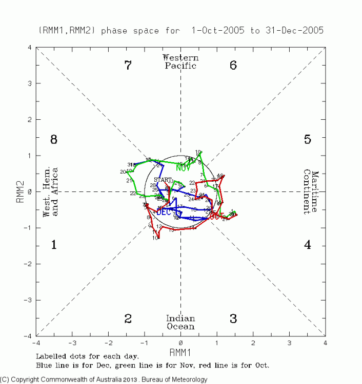
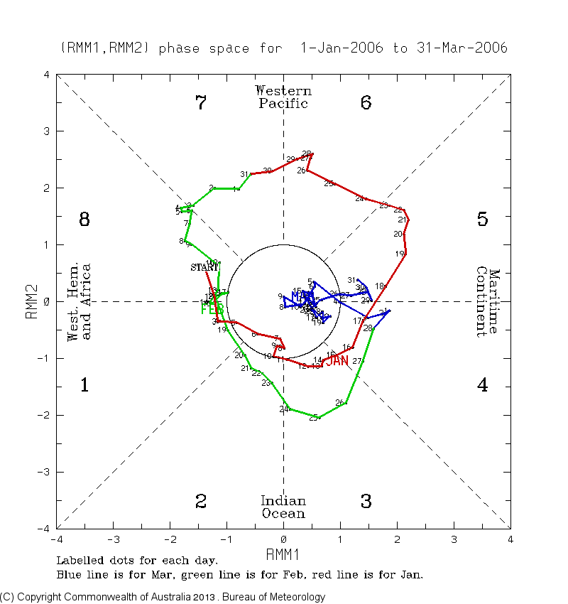
And then thereafter Jan-Mar 2006:

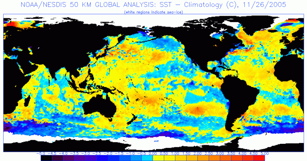
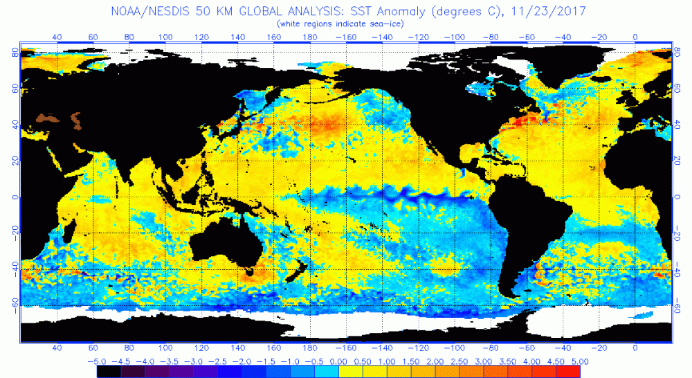
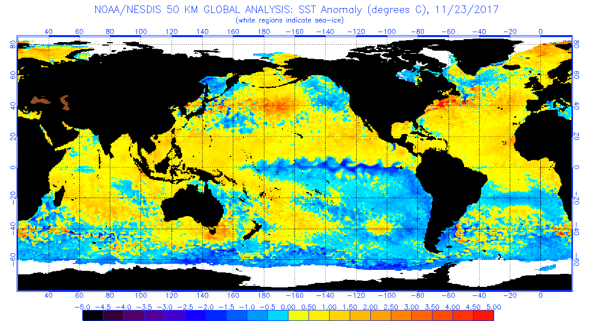
So one can see the 4-5-6 run that took a large chunk of January and then the Feb 11th nor'easter was smack in the middle of an 8-1-2 run. Overall, this particular winter wasn't really a great one outside of the early cold and snow in December and then the Feb storm. This is something that some forecasters (even JB) are considering as a good possibility of happening deeper into the winter... with the moderate/strong Nina driving a more dominant 4-5-6 regime equating to lots of above average in the east. It's also something I'm mindful of...but it doesn't necessarily have to happen though, especially if the Nina eventually starts to weaken. At any rate, that 2005-2006 analog isn't perfect by any means. Aside from that one being a weaker La Nina event than currently, SST anomalies in the rest of the Pac and Atlantic basins really don't match up well to what we have now. Both basins have larges swaths of above normal SST's now compared to being much cooler in 2005. 2017-2018 could get a look as an analog as well as the most recent La Nina and additionally one that the current Nina is tracking pretty close to numbers wise. That featured an Atlantic basin similar to now, although the N Pacific had more below normal SST's. That winter had its very warm stretches, esp in February.. but we fared a lot better with snow and also had the big hitter in late March and snow into April. It also had some shots of snow and cold in December (end of December was very cold). But back to the SST anomalies..
2005:
2017:
Now:

So you can see the 2017 map looks a good bit closer to what we have now, with the difference still being the warmer north Pacific (looking more like this time last year there). That much warmer Pac probably will have implications in the positioning of the jet stream in the EPO/WPO realm. So lots of things to consider, this Nina is unique with how warm the northern Pacific is when comparing to any of the other recent Nina's of the past 20 or so years as well (98-99, 99-00, 07-08, 10-11, 11-12). What that might mean for our sensible weather later this winter I'm not quite sure. And even though I'm expecting a somewhat below normal winter this year snow-wise, I still expect it to be much better than last year just simply because I'm betting on the side of statistics that we don't see such an anomalous and long lasting +AO regime and extremely strong polar vortex again this winter. I feel that was what made a bad winter last year historically bad since the overall setup last winter pretty much rendered northern branch events for us nonexistent since the ++AO regime had that northern jet too high while the other systems mostly cut west with the eastern ridge. Even in a bad winter we normally still at least get a decent event or two over the course of the seasonand that one didn't even do that. I do also think we're going to need more help from the NAO realm than usual to help keep the storm track under us more if we're presented with a traditional Nina pattern.
Well I really went into the rabbit hole with this, I don't usually dive too deep into these long range things but I'm trying to get better at analyzing this stuff. I am looking at this period coming up to start the first half of December with optimism though as like I mentioned, we look to have a period of opportunity. What happens beyond, we shall see. For the record I'm not writing anything off, good or bad.
Thanks so much for the update, Mag. It does look wet next week for sure in our parts per the 12z GFS this morning. This pattern seems active with colder air in place so as you said maybe something end of next week or before we get into mid-December.
-
26 minutes ago, Itstrainingtime said:
The 3 worst scenarios for you and me during any given winter:
1.) A Miller B that intensifies off the NJ coast.
2.) An Alberta Clipper that runs west to east across the turnpike
3.) Expecting wraparound snow, from well...anything
Exactly a pipe dream but I'm trying to track something.

-
1
-

Central PA - Winter 2020/2021
in Upstate New York/Pennsylvania
Posted
Your not kidding! This is the second low after we get nailed from the first one: