

paweather
-
Posts
10,467 -
Joined
-
Last visited
Content Type
Profiles
Blogs
Forums
American Weather
Media Demo
Store
Gallery
Posts posted by paweather
-
-
2 minutes ago, JTrout said:
Got a lot of the crew in PA!
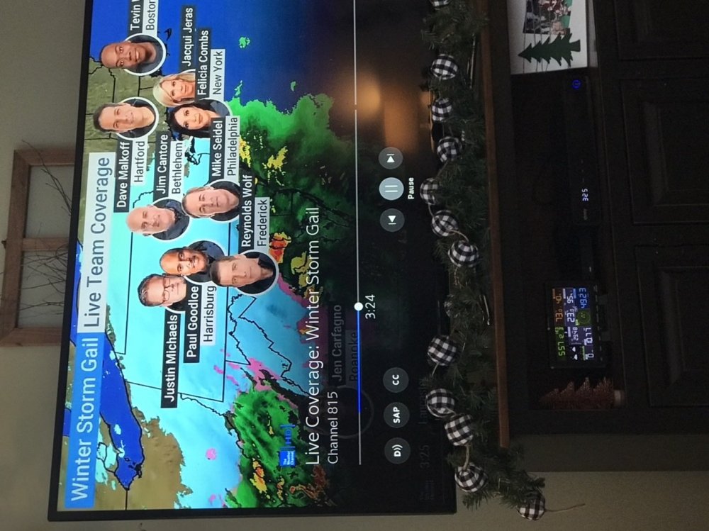
Cantore the kiss of snow death.

-
Winter Wonderland here now. 19z backed off a bit on mixing.
-
-
4 minutes ago, Itstrainingtime said:
Sleet line currently extends from Northeast Maryland SW through Baltimore City and on SW through the northern DC burbs. It's made a significant jog north in the past hour.
if you look at HRRR around 1z is where it is up into the LSV. Hope not to the extent it is showing on this model but between 1z - 3z that is where the risk is. Edit: maybe to 4z and then back to snow.
-
 1
1
-
-
-
What I am most concerned about on the HRRR is the mixing it is showing later in the evening, and also a potential dryslot but we will see.
-
1 minute ago, AllWeather said:
Yeah. That’s the good good right there.
You certainly see it developing down to our south. Maryland OBS are impressive with Heavy snow rates right now.
-
Right here folks. 18z HRRR:

-
The coastal is still down in NC.
-
2 minutes ago, CarlislePaWx said:
At 2:00pm I have picked up an additional 0.4" in the past hour and have a storm total of 1.1". During the past 15 minutes the rate has picked up noticeably but with fine flakes I would just call it a "heavy" light. The increased rate has caused my temp to drop a degree, now down to 24.3 degrees with a dew point of 21.4.
As others have said, we're only about an hour away from the start of the heavy snow with inch per hour rates.
Yep somewhere close to 3pm and thereafter.
-
Just now, canderson said:
I see people posting bust already since it has basically shut off for a bit.
In other news, I have people.
Dang I forgot to add this to my post yesterday on what we would hear! Thanks Canderson this is another one.
-
1
-
-
Finally starting to pick up intensity here. Still fairly light but waiting for the main course 3pm on....with heavier rates.
-
Per 17z HRRR this really gets cranking around 20z. 3pm.
-
Just now, NeffsvilleWx said:
I wouldn't expect the mixing threat to materialize until the offshore low really picks up steam.
Agreed, I am not concerned up this way on mixing. Things are just revolving now. further SE PA more mixing issues I think.
-
The good thing per MA forum obs, most of Maryland is all snow including DC. Mix is down south in VA.
-
HRRR brings the mix north a bit:

-
Roads Caved, Grass unCaved.
-
-
2 minutes ago, MAG5035 said:
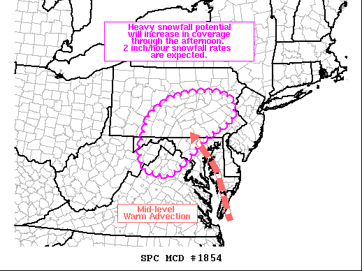
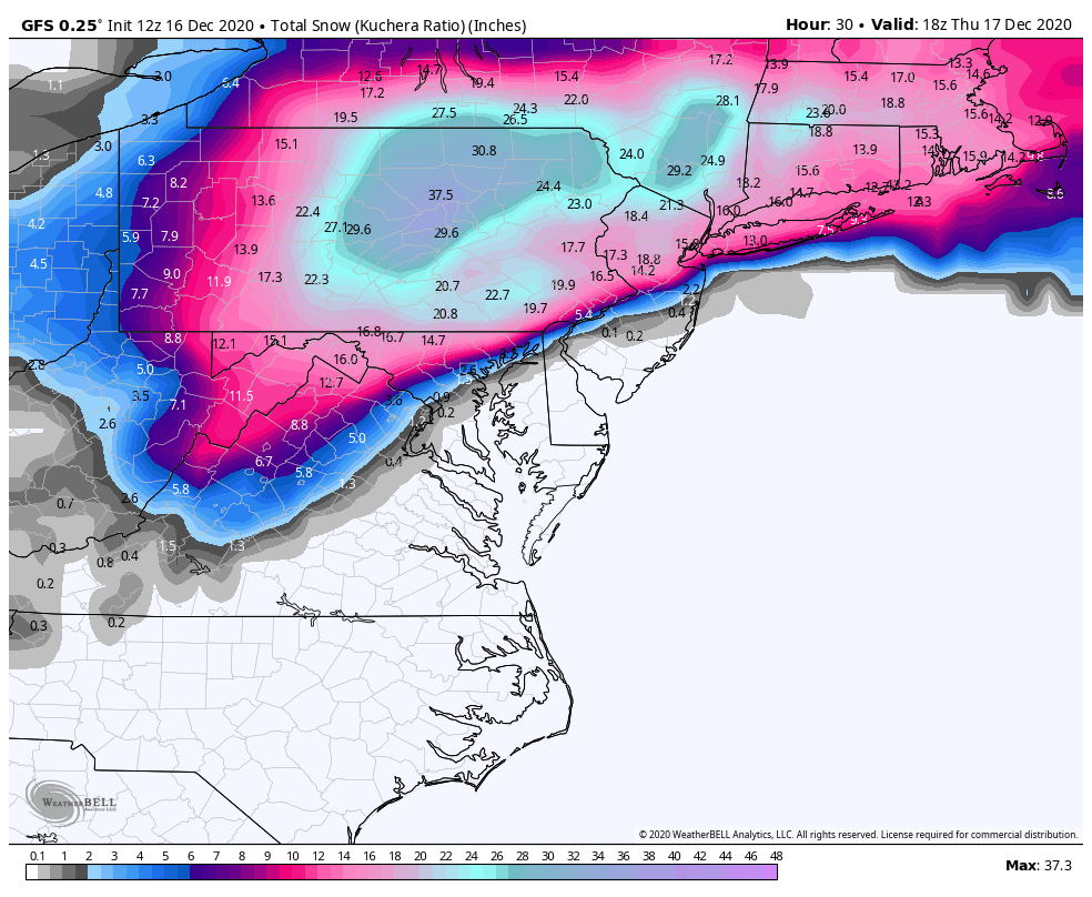
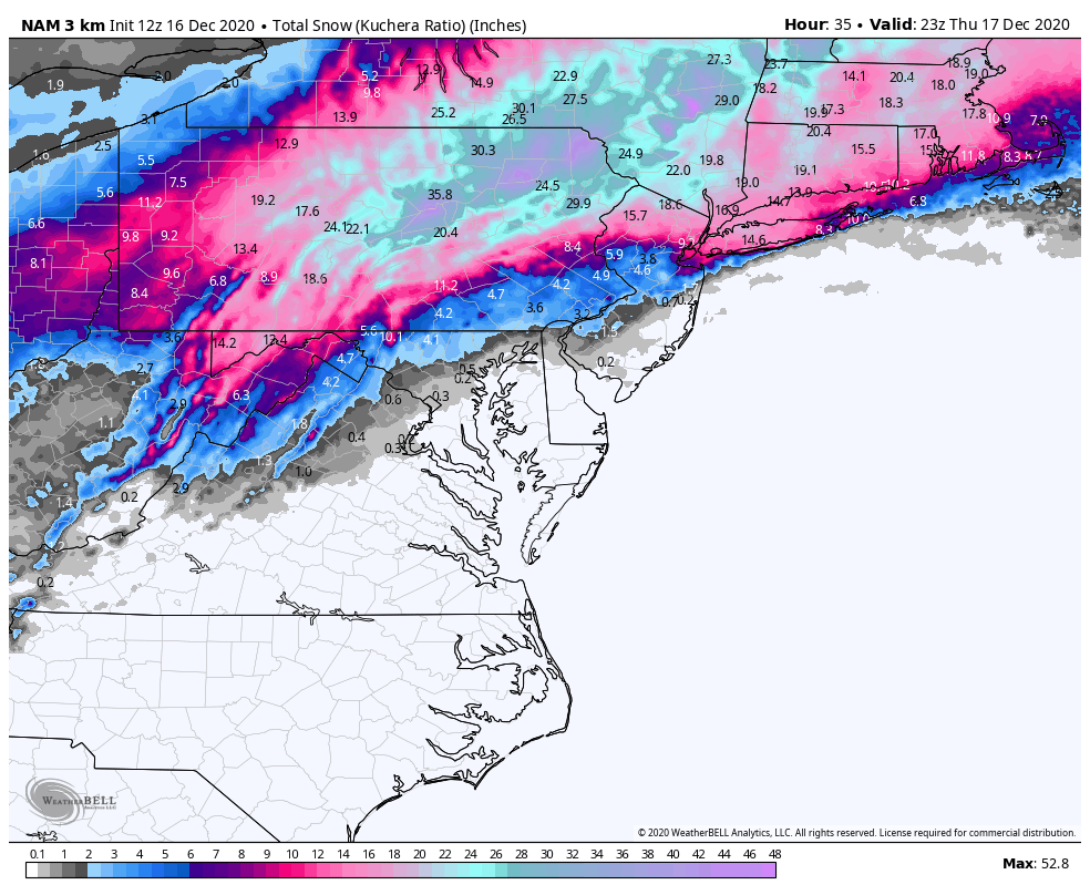
Wow, this might have been the snowiest GFS run of them all right at game time. Both that and the 3k NAM have 3' at IPT (via Kuchera). Huge difference in the York/LNS realm though. That's going to be something to watch today which model wins with the thermals. Heck the 3k NAM got sleet all the way to KAOO on a huge surge of >0ºC 850mb temps, that's probably not going to happen. York and Lancaster probably aren't quite going to get to 20+ either as there should be some mixing. Given already solid establishment of cold air at 925mb and below via the Canadian high, I still feel most mixing is going to be in the form of sleet north of the mason-dixon.

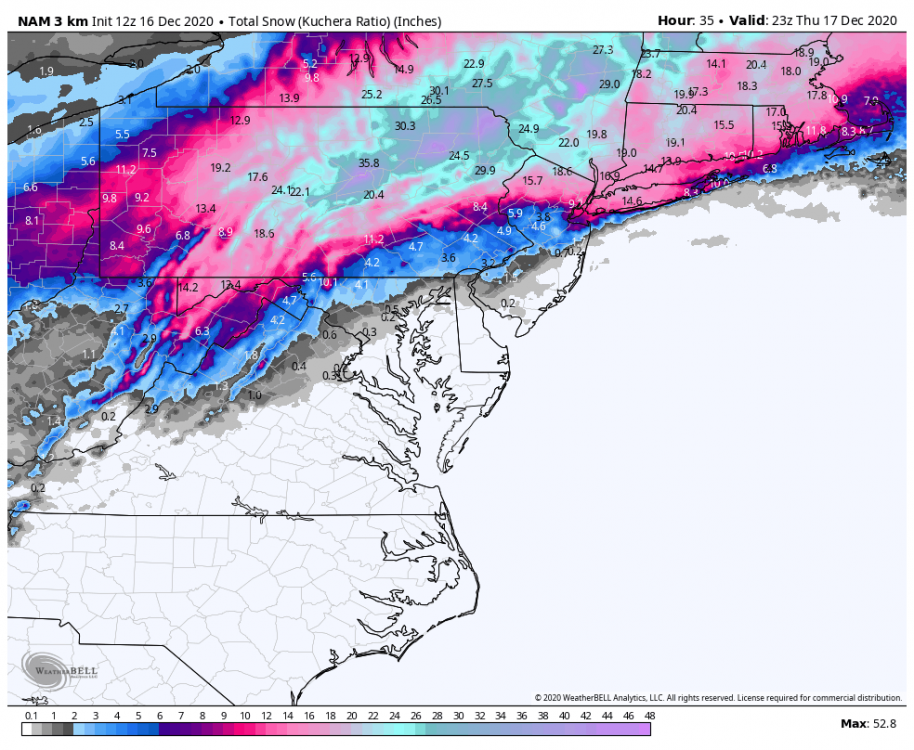
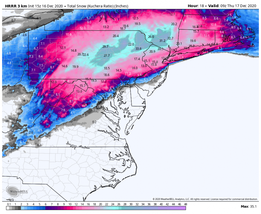
Here's the latest HRRR, which probably represents accums in the LSV a bit better currently with limited erosion of the accumulations in far southern York and Lancaster . Still snowing at 18hr in pretty much the whole eastern half of PA.
I was just going to say this Mag. I just looked at the GFS now and my god, this has to be one of the snowiest runs I've seen in a long time.
-
3 minutes ago, Itstrainingtime said:
Days like today help forget what this year has become. Enjoy all!
Boy can't say it any better than this!
-
-
2 minutes ago, Atomixwx said:
I lived right on the square above the pet shop. The sinkholes weren't as prevalent there as opposed to say, bowling alley, but the road was so busted that I slept every night to the sound of 18-wheelers breaking their axles at the red light and bums fighting outside of Gary's bar with the blood spilling over to the parking lot of Roma Pizza.
Fix that shit, and we'll give you snow.
HAHA. I live down the road by the high school development across the street. Been here all my life and nothing ever changes with Sinkholes in Palmyra.
-
Just now, Atomixwx said:
Palmyra doesn't get snow until it solves its sinkhole problems. That's why I left that one-horse town.
Your right we are one big sinkhole here, sinkhole capital of PA!
-
First Flakes - 10:49am.

December 16 2020 CTP Snowstorm Disco and Obs
in Upstate New York/Pennsylvania
Posted
Still looks like between 2z and 4z for mixing....heavy rates before it and heavy rates after change back to snow. Per HRRR 20z.