

paweather
-
Posts
10,331 -
Joined
-
Last visited
Content Type
Profiles
Blogs
Forums
American Weather
Media Demo
Store
Gallery
Posts posted by paweather
-
-
5 minutes ago, TheClimateChanger said:
Got to love it! I post topical climate data for central Pennsylvania, don't even mention climate change, and am accused of trolling. @PSUWhiteout70comes here posting completely off-topic conspiracy theories, and gets several likes.

Leave no questions asked....
-
9 minutes ago, TheClimateChanger said:
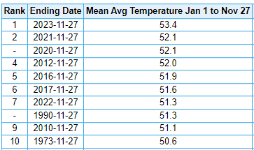
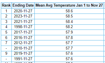
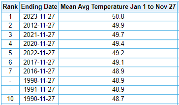
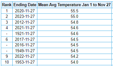
With a little over one month left in the year, 2023 continues to be in the running for one of the warmest years on record at several cities in the Commonwealth of Pennsylvania. Notably, it is easily the warmest on record at DuBois and Bradford, in the higher elevations of the north. Williamsport, Harrisburg, and Scranton/Wilkes-Barre area are all in second place to date - in the latter two cities, the records belong to the recent year of 2020; however, the record at Williamsport dates back more than 100 years (1921). While 1921 is the warmest through November 27, the record warmest year at IPT actually occurred much more recently in 2012 (as a warm December enabled that year to overtake the early 20th century challenger). Regardless, if we continue to run warmer than normal in December, this is shaping up to be an historic year weather-wise in the Commonwealth. I am looking forward, with much excitement, to sharing the final numbers in early January.
Williamsport (2nd warmest)
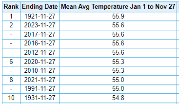
DuBois (warmest on record - a full 1.3F above #2!!!)
Harrisburg - Middleton (2nd place)
Bradford (warmest on record - by nearly a full degree!)
Scranton, Wilkes-Barre, Avoca, PA (2nd warmest)
Go do something else like fly a kite....
-
 1
1
-
-
14 minutes ago, Atomixwx said:
It's here!
Sent from my motorola edge 5G UW (2021) using Tapatalk
Have fun in it!
-
Why all of a sudden is Chesco and Climate Traveler posting at the same time and agreeing. Thanks for the 100" snowfall depths these last 3 years!
-
1
-
-
1 minute ago, TheClimateChanger said:
With all due respect, how is posting year to date climate statistics for the capital against the rules?
With all due respect go travel your dream...
-
3 minutes ago, TheClimateChanger said:
I'm going to have to disagree. I don't think anyone here knew it was that bad in 2019-2020 & 2022-2023 in Harrisburg. I certainly didn't, as I haven't seen it mentioned anywhere.
Go travel your dream......33 and windy with the sun out.
-
9 minutes ago, Mount Joy Snowman said:
Low of 32 and walked through some decent flurries on the way to work here in Harrisburg.
I echo the sentiments of others, in that I have absolutely no issue whatsoever with @ChescoWx posting in this forum. I mean, the guy usually posts once a day for crying out loud, in which he gives a nice concise forecast and summarizes his daily observations. No harm in that. You may quibble with him on his record keeping as it pertains to past comparisons, and that's fine, but the guy is harmless and sometimes posts useful data. The more the merrier, within reason ha.
Oh yeah, national low was only 82 at Ochopee, FL. Of course, the low was at Peter Sinks, checking in with a cool -31.
Sorry was just joking everyone gets so damn sensitive around here,

-
1
-
-
Car Topper in the books!
-
1
-
-
27 minutes ago, Blizzard of 93 said:
I enjoy his detailed posts & Chester county is literally the next county over from Lancaster.
He offers quality content that is beneficial to this thread.
That’s why I said with love LOL. Although I am tired of climate changer/dream traveler/Chesco they are all fair game for criticism and feedback like we all are!
-
1
-
-
10 minutes ago, ChescoWx said:
So another interesting chart for those who "feel" we don't see large snowstorms here in Chester County in the modern days. The below chart in fact shows that our last complete decade the period 2010-2019 featured the most 10" plus snow storms (13 of them) then any decade in our history. Plus the 3 snowstorms in the 2010's that exceeded 20" of snow during the decade is tied with the 1890's for most 20" plus snowstorms. For the decades with the least amount of large snow events we need to go all the way back to the 1940's and 1970's. Those 2 decades both finished with less than 10 storms the entire decade that measured over 6". I suspect we are due for some less snowy decades as that is the simple cyclical nature of weather.

Can I recommend you move your posting to the Philly forum they would enjoy that Chester is not part of this sub forum thanks with love!
-
1
-
-
7 minutes ago, Itstrainingtime said:
There is at least one met (yeah, that guy from MU) that said a month ago that we would be waiting a good long time for snow...
What does a good long time mean...April?
-
28 minutes ago, Atomixwx said:
Didn't somebody punt on the next three winters due to the volcano eruption from last year?
Reading DT's tweet, the Pacific jet remains king. I feel like until it dies, and there's nothing to say it will, we're no different than Seattle.
It's been a flizzard all morning, which is nice.
Sent from my motorola edge 5G UW (2021) using Tapatalk
It is always something...if not a -nao +pna its the pacific.

-
@Blizzard of 93Is it time to cancel winter yet?
-
1 hour ago, Bubbler86 said:
Teens possible in colder places early next week....maybe that finally puts an end to mowing season?
Snow mowing starts
-
1
-
-
2 minutes ago, Bubbler86 said:
Thanks!!
-
 2
2
-
-
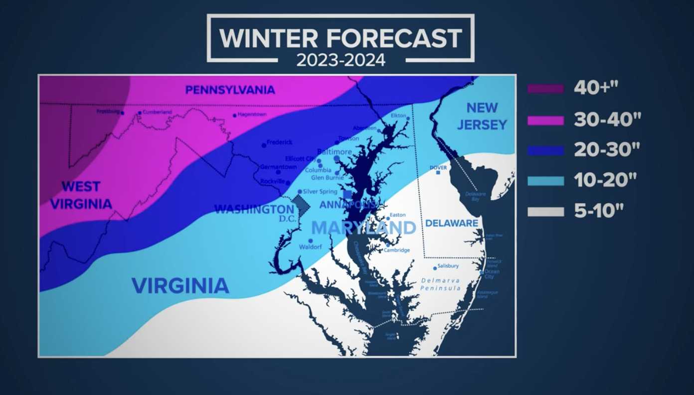
2 hours ago, TheDreamTraveler said:
Some slightly good snow news for winter potentially
Thanks ClimateChanger
-
2
-
-
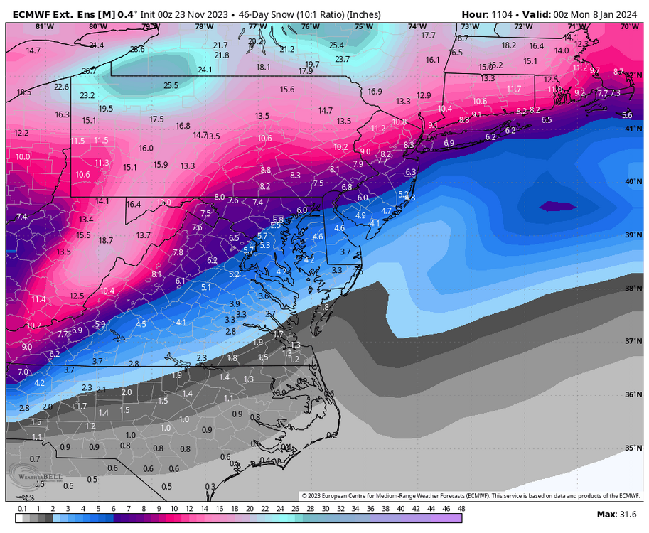
1 hour ago, ChescoWx said:
That looks like about the normal average snowfall for most spots on that map...
This is a ensemble map not operational.
-
-
-
Happy Thanksgiving everyone let it snow for all!!! Except Voyager well he is in Phoenix anyways….oh well we will share with him!
-
2
-
1
-
-
Dreaming:
TodayPartly sunny, with a temperature falling to around 29 by 5pm. West northwest wind 10 to 18 mph.TonightSnow, mainly after 11pm. Low around 14. North wind 9 to 14 mph increasing to 17 to 22 mph after midnight. Chance of precipitation is 90%. New snow accumulation of around 3 inches.Thanksgiving DaySnow. The snow could be heavy at times. Temperature falling to around 7 by 4pm. Wind chill values as low as -15. North wind 23 to 26 mph. Chance of precipitation is 100%. New snow accumulation of around 6 inches.Thursday NightSnow likely, mainly before 11pm. Cloudy, with a low around 8. Wind chill values as low as -15. North wind 25 to 32 mph, with gusts as high as 45 mph. Chance of precipitation is 70%. New snow accumulation of around 2 inches. -
6 minutes ago, Bubbler86 said:
Yea, last winter.....in the 50's. LOL. The hot house this week, Lancaster, is already in the mid 50's.
Yeah haven't been outside just looks that way.
-
1
-
-
Looks like a winter morning.
-
Zero here wait time for me.


Central PA Autumn 2023
in Upstate New York/Pennsylvania
Posted
22 and sunny and a new day.