

paweather
-
Posts
10,328 -
Joined
-
Last visited
Content Type
Profiles
Blogs
Forums
American Weather
Media Demo
Store
Gallery
Posts posted by paweather
-
-
12z GFS looking good for a Cold Start to the New Year and possible snow!
-
7 minutes ago, Blizzard of 93 said:
Sorry that I lost my cool this morning.
I am generally entertained by your posts.
I hope that you & your family have great holidays.
All good @Blizzard of 93 we know the pattern is changing. Just not the specifics of when yet.
-
5 minutes ago, mitchnick said:
No way slp would head for the GL with the ensemble mean 500mb and 250mb wind flow.
Thanks Mitch notice @Bubbler86did the GFS takes it into the lakes. I hope this is the one,
-
5 minutes ago, Superstorm said:
Was just about to post that. Yes, great to see it respond.
.Yep here it comes....
-
 1
1
-
-
-
2 minutes ago, Bubbler86 said:
Late nooners. Mostly Sunny and 35.
Nice chilly nooner 43 and Sunny here.
-
1
-
-
1 minute ago, TimB said:
None of those years start with 2. Strange.
So Strange.
 Climate change is our death.
-
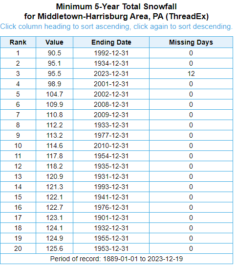
2 minutes ago, TheClimateChanger said:
Assuming less than 3.5 inches falls between now and the end of the month, this is the third lowest 5-year snowfall on record at MDT - behind only the 5-year periods ending on 12/31/1934 & 12/31/1992.
OMG how did I know Climate Changer would in the house telling us about anti snow.
-
 1
1
-
-
3 minutes ago, Itstrainingtime said:
Elliott on next week's rain potential (and beyond):
Not until next Tuesday or Wednesday should a storm system move into the Ohio Valley and mid-Atlantic States and bring the next round of unsettled weather to the region. This system will likely bring rain to parts of the Deep South, Tennessee Valley, and Midwest on Christmas Day but face resistance from the large high pressure system over New England. Regardless of the system's timing, temperatures will be way too high and the storm track too far north/west for any wintry precipitation in the entire mid-Atlantic region. Thus, another soaking rainfall is a "good bet" at some point during the middle of next week, but amounts should not be high enough for any more flooding concerns. As mentioned, it will also be another "mild rainstorm" with temperatures in the 40s or 50s. 'Tis the norm in December during strong El Niño winters. As for snow and ice, the tide may turn in early- to mid-January, but it'll be a "no-show" until then. Cue the old adage, "Patience is a virtue".. -- Elliott
Elliot has been spot on. He has not wavered at all with his predictions. and @Bubbler86 correct on the MA forum. Lots want it to snow snow snow like myself but as Elliot says we need patience. I don't have much of that but trying hard. LOL.
-
1
-
-
1 minute ago, Bubbler86 said:
Yea, on the 6Z. Eastern side of the country is evacuated of BN temps on the 27th. Not a torch either, just mild. Colder air works in after Jan 1 but only for a few days as it looks transient. Just a PBP on an Op model, not a forecast.

Yep. Let's see what we get today. PBP is good and certainly if 6z is correct that is what happens.
-
26 minutes ago, Bubbler86 said:
Several 50's on the GFS for post-Christmas week into New Year Day so if that is close, it will probably rise indeed...from the current 3.2.
Reviewing 6z? Makes sense...we shall see.
-
29 and Sunny. Weather will be headed in the right direction after Santa.
-
Nooner 35 and Flurries feels like winter.
-
2
-
-
10 hours ago, Blizzard of 93 said:
It’s not like I make stuff up!
I post models & maybe make a few comments to support what I post.
But I guess that’s just bad posting?
Give me a freaking break!
BLizz just keep doing what your doing. I agree I said late next week it begins.
-
9 minutes ago, Bubbler86 said:
GFS throwing stuff at the wall now.

Looks good this far out LOL
-
3 minutes ago, Bubbler86 said:
You could have started thing about sprots or something and held out longer so your money shot was this.....

I saw it......But decided against posting at 384 map..
-
1
-
-
The reversal begins:

-
1
-
-
1 minute ago, Atomixwx said:
McKean-Elk-Clearfield-Cambria-
Including the cities of Bradford, St. Marys, Ridgway, DuBois, Clearfield, and Johnstown
220 PM EST Sun Dec 17 2023
...WINTER WEATHER ADVISORY IN EFFECT FROM 1 PM MONDAY TO 10 AM EST TUESDAY...
* WHAT...Snow expected. Total snow accumulations of 2 to 4 inches. Winds gusting as high as 40 mph.
* WHERE...McKean, Elk, Clearfield and Cambria Counties.
* WHEN...From 1 PM Monday to 10 AM EST Tuesday.
* IMPACTS...Plan on slippery road conditions. The hazardous conditions could impact the morning or evening commute.
* ADDITIONAL DETAILS...The periods of heaviest snowfall and travel impacts are expected between 8 PM Monday and 8 AM Tuesday as temperatures drop below freezing.
PRECAUTIONARY/PREPAREDNESS ACTIONS...
The Pennsylvania Department of Transportation and Pennsylvania Turnpike Commission remind motorists to adjust speeds based on driving conditions as winter weather impacts will include snow covered roads and limited visibility.
Call 5 1 1 or visit www.511pa.com for the latest travel, roadway and traffic conditions.
To report snow or ice, post to the NWS State College Facebook page, use Twitter @NWSStateCollege, or visit weather.gov/ctp.
Sent from my motorola edge 5G UW (2021) using Tapatalk
Excellent Enjoy!!!
-
10 minutes ago, Atomixwx said:
I have been advised. Fun.
Sent from my motorola edge 5G UW (2021) using Tapatalk
Advised of what?
-
3 minutes ago, TimB said:
I’m certainly not TCC or the other guy.
Oh OK sounds good
-
3
-
-
46 minutes ago, Wmsptwx said:
Why does it make you so angry to talk about CC? I really don’t get why anger is the response.
Because he has 10 different screen names that’s why. He serves no purpose in here.
-
1
-
-
56 minutes ago, PSUWhiteout70 said:
Opinions vary.
Exactly!
-
1
-
-
2 hours ago, Itstrainingtime said:
Useless to society isn't fair or accurate.
I’m sorry when someone uses 10 different screen names that is useless.
-
4 hours ago, mitchnick said:
Let's just not engage CC or his alter ego TimB. They are not happy souls. Has either ever posted anything positive for cold and/or snow? Of course not, and it's intentional. The whole purpose is to bring everyone down their dark, depressing hole. Best to leave them in their corner alone because they are not here to sincerely discuss weather and there's nothing anyone on this Board can do to cure them.
Agree 100% TimB climate change and dream traveler they don’t have anything to do but jack our forum up all are useless to society
-
1
-


Central PA Winter 23/24
in Upstate New York/Pennsylvania
Posted
You got it my man. New Year and more SNOW.