USCAPEWEATHERAF
-
Posts
8,736 -
Joined
-
Last visited
Content Type
Profiles
Blogs
Forums
American Weather
Media Demo
Store
Gallery
Everything posted by USCAPEWEATHERAF
-
Rain, likely. I think the storm track is still uncertain until the storm hits the coastline. Right now the greatest pressure falls/3 hours is just off the NE North Carolina coast, right off of Cape Elizabeth, NC, of around 5mb/3 hours
-
While I need to be more objective, this storm is getting colder on observations down south. I think we should lean towards a colder scenario across SNE. Does that mean Harwich sees more snow than 3-5", I don't know yet.
-
Our storm center is strengthening, down to 1004.9mb, over the NE GA and NW SC border looks southeast of the models.
-
35F/30F, Harwich, MA
-

Perhaps a Coastal Storm on March 2nd for SNE????
USCAPEWEATHERAF replied to USCAPEWEATHERAF's topic in New England
I should have stayed with a max of 10" not gone and increased it to 16" -
Perhaps a Coastal Storm on March 2nd for SNE????
USCAPEWEATHERAF replied to USCAPEWEATHERAF's topic in New England
I'm heading to bed, waking up in a few hours to check on the storm's progress. Hopefully, the GFS is right with this storm. -
Perhaps a Coastal Storm on March 2nd for SNE????
USCAPEWEATHERAF replied to USCAPEWEATHERAF's topic in New England
I wouldn't worry about that unless the 00z GFS comes in agreement. -
Perhaps a Coastal Storm on March 2nd for SNE????
USCAPEWEATHERAF replied to USCAPEWEATHERAF's topic in New England
Yes but the greatest pressure fall couplet, is over Norfolk, and SE Virginia. -
Perhaps a Coastal Storm on March 2nd for SNE????
USCAPEWEATHERAF replied to USCAPEWEATHERAF's topic in New England
Be patient, the main development is just getting underway, between 3-6z is when the low really starts to take off right off the Delmarva. -
Perhaps a Coastal Storm on March 2nd for SNE????
USCAPEWEATHERAF replied to USCAPEWEATHERAF's topic in New England
Greatest pressure falls as of this hour are over Norfolk and the SE Virginia region, not over Cape Hatteras, NC, that means the low may be developing further northward. -
Perhaps a Coastal Storm on March 2nd for SNE????
USCAPEWEATHERAF replied to USCAPEWEATHERAF's topic in New England
I would say around 3-6z tongiht is when the crucial part of the surface low development and track come into play as the convection matures off the coast, that is when the models pivot the low more northward then eastward. Patience everyone, soon the satellite will look like its supposed to with the low moving up the coast. -
Perhaps a Coastal Storm on March 2nd for SNE????
USCAPEWEATHERAF replied to USCAPEWEATHERAF's topic in New England
There is good news on satellite imagery, the line of thunderstorms east of NC are actually developing much closer to the coast of Cape Hatteras. -
Perhaps a Coastal Storm on March 2nd for SNE????
USCAPEWEATHERAF replied to USCAPEWEATHERAF's topic in New England
Scott if it helps any, the precipitation in bands is moving NNEward -
Perhaps a Coastal Storm on March 2nd for SNE????
USCAPEWEATHERAF replied to USCAPEWEATHERAF's topic in New England
Yeah I can barely stay awake right now, I need to be awake for when the snow starts up tonight. Bands already moving past ACK, but ACK is not reporting any precipitation, not sure what the official observations say, Brian can you check that out when you get a chance. -
Perhaps a Coastal Storm on March 2nd for SNE????
USCAPEWEATHERAF replied to USCAPEWEATHERAF's topic in New England
No the EURO and GFS have been quite steadfast, unless you are talking about heavy snow potential areas west of I95 corridor. I think Hartford, CT is in trouble and less confidence. -
Perhaps a Coastal Storm on March 2nd for SNE????
USCAPEWEATHERAF replied to USCAPEWEATHERAF's topic in New England
I agree. They were a step in the right direction and so was the 2z HRRR model run, they are slowing down the progress of the storm. -
Perhaps a Coastal Storm on March 2nd for SNE????
USCAPEWEATHERAF replied to USCAPEWEATHERAF's topic in New England
Low-level bands developing out ahead of the main storm, down in NC.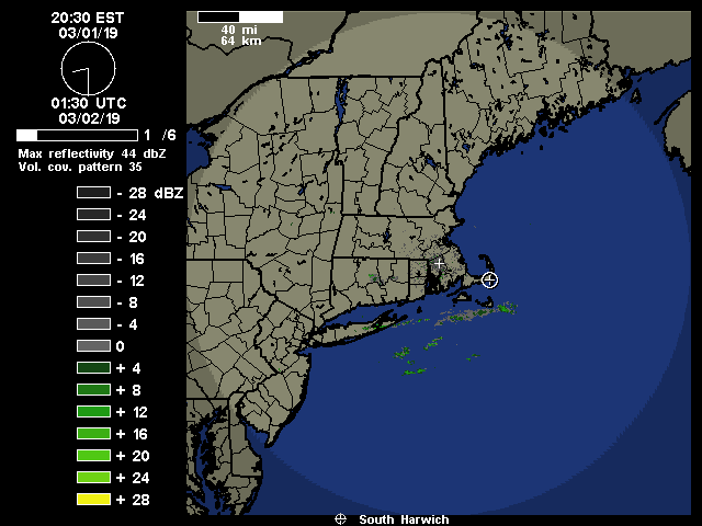
-
Perhaps a Coastal Storm on March 2nd for SNE????
USCAPEWEATHERAF replied to USCAPEWEATHERAF's topic in New England
About a -1.0mb/hour in the last hour over Cape Hatteras, NC. Lightning off the NC coastline, maybe push the surface low further northwest. -
Perhaps a Coastal Storm on March 2nd for SNE????
USCAPEWEATHERAF replied to USCAPEWEATHERAF's topic in New England
Low level precipitation bands developing south of ACK and MVY. -
Perhaps a Coastal Storm on March 2nd for SNE????
USCAPEWEATHERAF replied to USCAPEWEATHERAF's topic in New England
Thanks TIP, I explained why I went bullish -
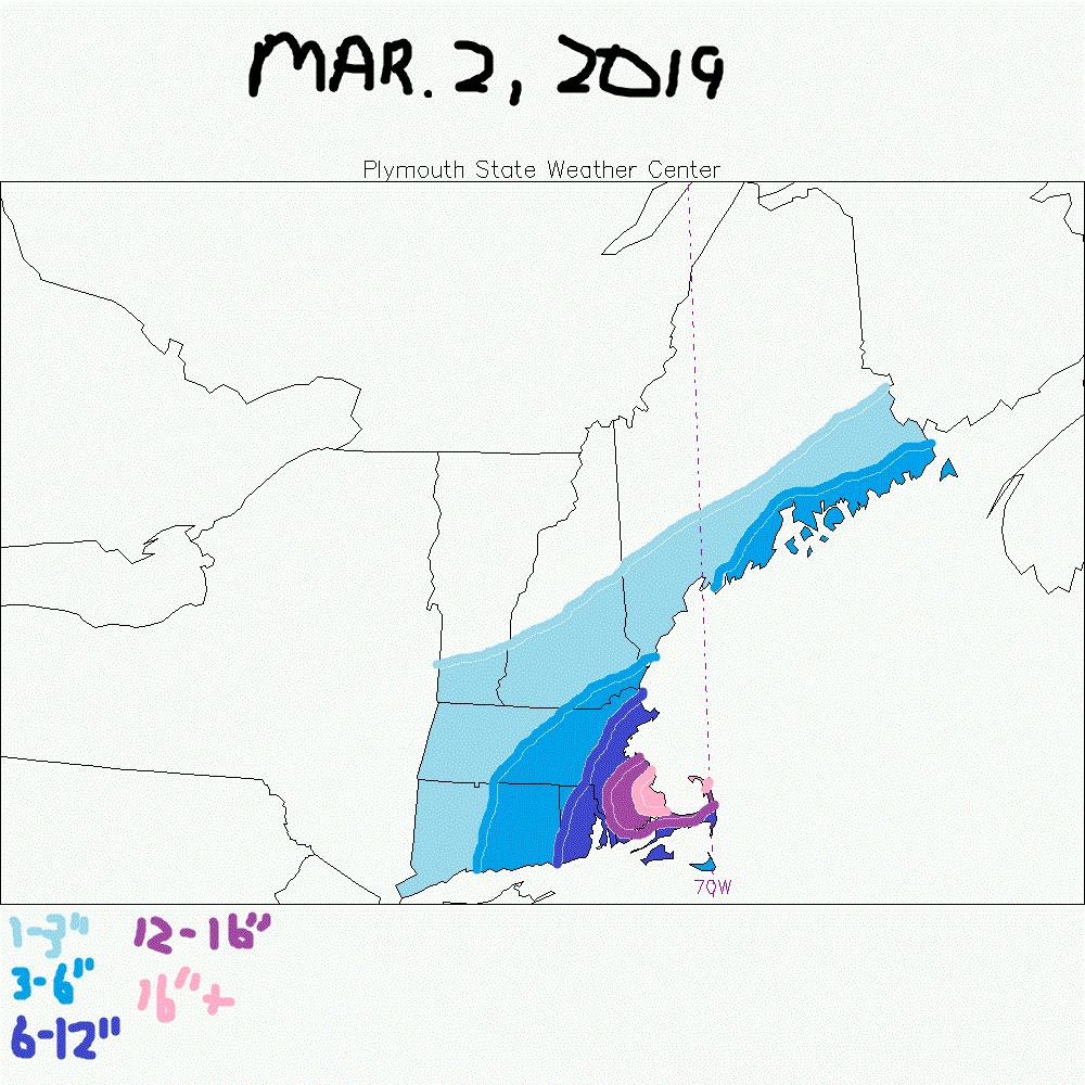
Here is my latest snow map:
-
Perhaps a Coastal Storm on March 2nd for SNE????
USCAPEWEATHERAF replied to USCAPEWEATHERAF's topic in New England
I'm siding with the 18z GFS given current trends in satellite imager, short range HRRR, 3km NAM models and their intensities. Winds could become a bigger issue according to the 3KM NAM. Blizzard conditions are a possibility along with thundersnows across the Cape. We enter the Warm conveyor belt and the ccb develops overhead along with potential comma head dynamics towards 6-12z tomorrow. Snow duration is expected to be around 18-20 hours, along with the potential for the H7-H92 lows to close off just southeast of CHH tomorrow midday. Along with the likelihood for intense cyclogenesis as thunderstorms erupt off the Delaware coastline. Also with the intensity of the lift and convection associated with the primary low over NE Tennessee currently and with the primary shortwave negative tilt along with intense frontogenesis likely and vertical velocties will lead to intense lift(omega) in the DGZ (Dendritic Growth Zone). Also the duration of the speed of the storm looks to slow down according to the HRRR guidance. Ocean enhancement along with potential coastal front development will likely lead to higher snowfall totals of near a foot and a half over Plymouth and Bristol counties in MA, with Provincetown, MA likely far enough north to miss out on mixing and where potential banding could be maximized.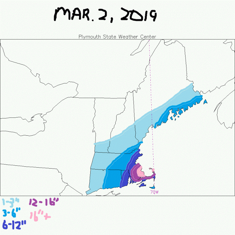
-
Perhaps a Coastal Storm on March 2nd for SNE????
USCAPEWEATHERAF replied to USCAPEWEATHERAF's topic in New England
I think it is stupid to have both storms snowfall maps combined. This storm alone could produce a foot or more across eastern/southeastern MA. -
Perhaps a Coastal Storm on March 2nd for SNE????
USCAPEWEATHERAF replied to USCAPEWEATHERAF's topic in New England
Oh I am not saying it is strong or anything just yet, it is just a reflection. The primary low is 1013mb and intensifying with intense lift developing ahead of it. That is the main show for the next 6 hours. -
Perhaps a Coastal Storm on March 2nd for SNE????
USCAPEWEATHERAF replied to USCAPEWEATHERAF's topic in New England
Is it colder?