

LongBeachSurfFreak
-
Posts
8,548 -
Joined
-
Last visited
Content Type
Profiles
Blogs
Forums
American Weather
Media Demo
Store
Gallery
Posts posted by LongBeachSurfFreak
-
-
5 hours ago, Cfa said:
Meanwhile low temperatures look to remain above freezing for the foreseeable future, smart.
The thing is today’s event had a chance of busting high and being 6”+ .00000001% and the November event by say 10%. That one came down to temps not available precipitation. So there really is no excuse for dumping loads of salt. Being that I’m in the horticulture industry my mind went right to vegetation but there are a ton of other negative consequences. Vehicles, pets and local waterways are just a few. We aren’t talking the same salt you sprinkle on food.
-
Well NYC put down a ridiculous amount of salt again. At this rate they are going to kill the rest of the trees.
-
Pretty cool here on the uws, snowing at the tops of the tallest buildings, 300’+ but light rain at the surfaces with a few flakes. Melting is occurring very close to the surface.
-
 1
1
-
-
4 minutes ago, bluewave said:
Light snow here in SW Suffolk with a dusting on the colder surfaces.
Actually have a slight dusting here. Looks like the day goes in as .1 so far. At least December isn’t totally shut out now.
-
Light snow/flurries have begun in wantagh.
-
42 minutes ago, Damage In Tolland said:
Snowy day tomorrow 395 west

I just love how Woodford is shown for Vermont instead of Bennington Or Brattleboro!
this one looks like a pocono special
-
2 hours ago, Toekneeweather said:
Yes and warm water temps will most times fuel the system offshore making it stronger.
There’s allot more to it then that tony, I was referring to near shore water temps. It’s the offshore water temps and more specifically the Gulf Stream this feed our nor’easters. The Gulf Stream has been running hot as it’s source region has above normal water temps. That’s where you get the fuel.
-
1
-
-
On 12/10/2018 at 11:46 AM, bluewave said:
Earliest 12" 1-day snowfall total at GSO and 3rd highest on record.
Maximum 1-Day Total Snowfall
for Greensboro Area, NC (ThreadEx)
Rank, Value, EndingDate
1, 20.0, 1927-03-03
2, 14.3, 1930-12-17
3, 12.0, 2018-12-09
4, 11.1, 1960-03-09
5, 10.7, 1969-03-01
6, 10.2, 1987-01-22
7, 10.0, 1940-01-24
8, 9.3, 1979-02-18
9, 8.6, 1988-01-07
-, 8.6, 1960-02-13Period of record: 1903-01-01 to 2018-12-09
Strange that 1993 is missing
-
2 hours ago, qg_omega said:
Water temperatures are almost irrelevant for most coastal storms
That’s so incredibly untrue. Water temp plays a big role in early season events. December 05 and October 11 are great examples
-
4 minutes ago, Ginx snewx said:
I wouldn't punt anything at all. This going under us is a saving grace for ski areas, huge huge snow making bases all over even southern locales. Bluebird wx near 40, I mean cmon no better, ice skating and skiing for you winter enthusiasts should be awesome, go go go
Well you got that right fairly early. And I’m glad you did. The last thing we needed was a pack destroyer In the mountains. Just compare December 15 with current and see where the resorts are at. Pretty incredible start!
-
1 hour ago, nycwinter said:
we had 6 inches of snow with water temps in the 50's in november...
Not sure your point here. That was one event with extreme circumstances. I’m talking more marginal events where we would change to rain with 50s water temps. Great example, December 2005.
-
1
-
-
31 minutes ago, LibertyBell said:
I was just thinking that....my first bench mark is for water temps to get below 50 before the start of December, which has already happened, now I'd like them to be below 40 by the end of December ;-)
Once we get into the 30s it’s really game time for the coast.
-
1 hour ago, bluewave said:
This was actually the coldest first 10 days of December in NYC since 2010. Just goes to show the persistence of the colder pattern which began in mid-October. The average temperature from 10-15 to 12-10 was the coldest since 2002 in NYC.
Dec 1-10 NYC average temperature
2018....37.6
2017....43.0
2016....41.4
2015....48.3
2014....40.2
2013....41.9
2012....46.0
2011....46.7
2010....34.6
Coldest 10-15 to 12-10 in NYC since 2000:
#1....44.2....2002
#2....45.0....2018
#3....46.0....2000
One good thing is the we are knocking down water temps. This should help coastal areas moving forward.
-
2
-
-
4 minutes ago, qg_omega said:
I don't understand what's wrong, they are right on the water.
Exactly, I live right on the water, and this happens frequently. Drive 2 miles away from the water and boom there’s snow.
-
1 hour ago, CPcantmeasuresnow said:
It wasn't weird, it was horrible. Like something out of your worst nightmare.
Agreed, that was the ultimate disaster for anyone that likes skiing or riding. A cold and dry pattern isn’t much fun either, especially for me as I work outside.
-
1
-
-
Currently heavy citrus. Actually it’s pretty cool if you look up you can see it moving fast in the jet.
-
1
-
-
11 hours ago, Ginx snewx said:
Next weekend, midweek looks pretty bluebird sweet
Yeah your right, I should have clarified that I’m a weekend warrior. At least I scored 4 times already. It’s going to be a bitch going from mid winter conditions to starting the season over again.
-
Next week looks like complete disaster. I’m taking the weekend off but for anyone that’s skiing or ridding this weekend enjoy!!
-
30 minutes ago, NJwx85 said:
The big cut off low modeled for the end of next week is exciting.
What's not to love about PWAT's that are 3-4 STD above normal in mid December?
As modeled this would be a ton of rain and wind, similar to what we saw in March 2010 if the ULL deepens enough.

Yeah um that’s going to destroy an epic start to the ski season
-
2
-
 1
1
-
-
My fear is we do see the NW trend. But just not enough. And we see DCA over to ACY get a decent hit while we partly cloudy.
-
10 hours ago, Sugarloaf1989 said:
Excellent skiing conditions at Bromley on Saturday with nearly all trails opened. Summit above the clouds part of the day.
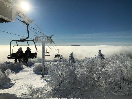
Awesome! Considering I have driven past bromley 100 times and have never ridden there I’m intrigued. I know they call it the sun mountain because it faces south. How was it? I’m assuming amazing considering what we had at Stratton!
-
Let’s see if we can get the NW trend that the models have had as we get closer to events the last few winters. Right now I would be allot more excited if I were down in DCA then here though...
-
Half inch of sleet at 1200’. Full on ice storm above 2000’. Trees bent over type stuff.
-
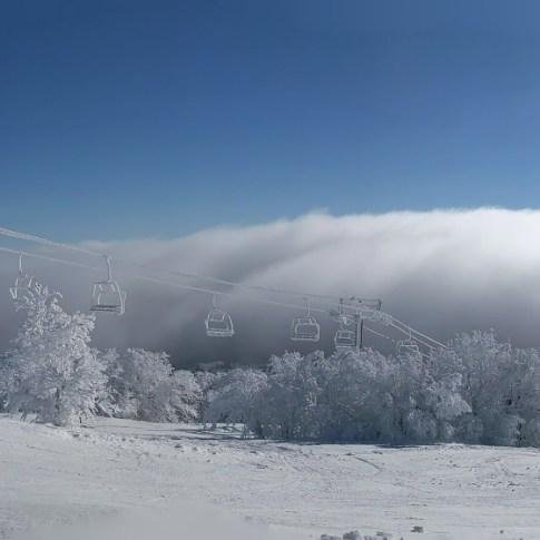
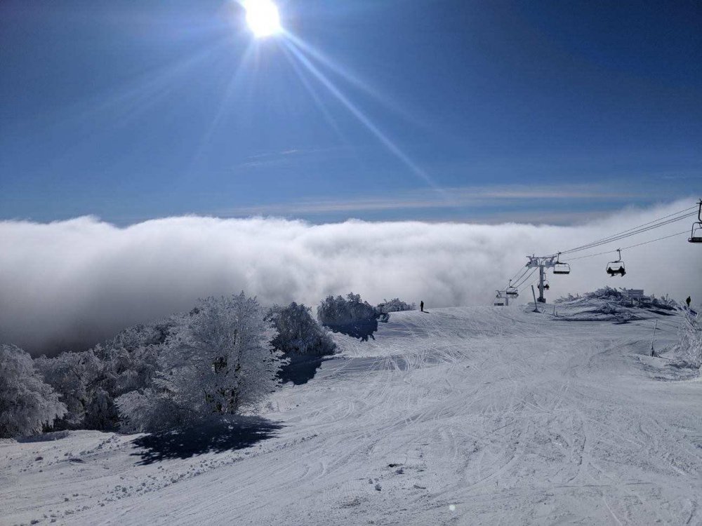
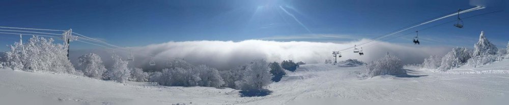
I had the pleasure of capturing and witnessing true diamond dust today.
ohh and today was about as perfect a day on the mountain as I have had. Blue bird with zero wind above the low cloud deck.

-
2
-


Meteorological Winter 2018 Banter
in New York City Metro
Posted
That was the only real ice storm I have experienced. I’ll never forget the next morning looking out my door and seeing the trees shinning. I have seen some good ice in Vermont since. 2 weekends ago there was a decent ice storm above 2000’. A real birch bender with some of the trails at Stratton blocked by bent over trees. It’s only a matter of time until we see a major crippling ice storm. That’s the one extreme weather event we haven’t had in recent years.