LongBeachSurfFreak
-
Posts
8,893 -
Joined
-
Last visited
Content Type
Profiles
Blogs
Forums
American Weather
Media Demo
Store
Gallery
Everything posted by LongBeachSurfFreak
-
Long period swells from Patrica worked their magic and caused washovers and erosion. Long period swells (over 12 seconds) are extremely energetic and surge up and over the beach. I had the pleasure of riding those swells last night and it was a memorable session at Gilgo beach.

-
 4.59” wantagh meso. Lots of flooding at Jones beach where I am currently
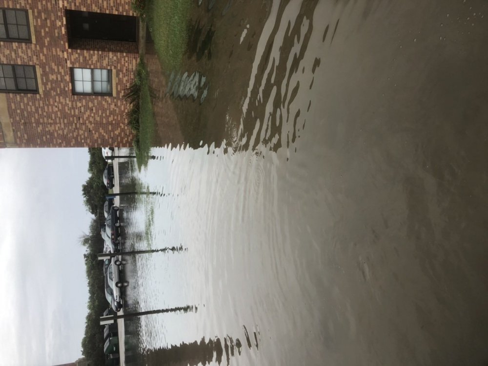
-
2020 Atlantic Hurricane Season
LongBeachSurfFreak replied to Windspeed's topic in Tropical Headquarters
A recurving major would be fantastic (as a surfer) but not where I would look. The MDR off Africa has clearly been a mess this season. If and when the next major forms it’s likely to be closer to land. The OHC is out there, we just need a storm to enter an area of low shear and it’s off to the races. I wouldn’t rule out a cat 5 -
2020 Atlantic Hurricane Season
LongBeachSurfFreak replied to Windspeed's topic in Tropical Headquarters
I mean part of an active season, especially hyperactive is your general September central Atlantic hurricanes. They usually produce a big chunk of ACE and most of the hyperactive years have them. I just enjoy tracking, attempting forecasts and observing the outcomes. Whether they are land threats or not matters little to me. Though I would prefer they avoid populated areas. A big CV hurricane is my favorite even if it threatens nothing but shipping. Aside from Dorian, Lorenzo was an incredible storm to track as well last year. Perhaps we'll get a few beasts over the next month. Over the years some big offshore CV hurricanes have killed more people on the east coast then many would believe. Rip currents caused by the resultant swell are real killers. Some classics like Gabrielle in 89 had double digit deaths. Large battering waves can also cause erosion and beach washovers. Bill in 08 caused a ton of damage at Jones Beach NY where I have been a life guard for 22 years. The East Coast with it’s sandy beaches is very prone to erosion caused by high energy long period swells. I have watched the beach washed clean (all snow fencing destroyed) under sunny sky’s on numerous occasions. Moral of the story, I find the term fish storm annoying. -
I would go with the repeating pattern. Torch October and arctic outbreaks in November
-
2020 Atlantic Hurricane Season
LongBeachSurfFreak replied to Windspeed's topic in Tropical Headquarters
Exactly. In terms of what the general public thinks of this season ACE numbers are meaningless. You need a functioning MDR to bring higher ACE numbers. One Ivan or Irma can inflate numbers. -
My parents trees are starting to grow back some leaves. They defoliated so bad I was worried they wouldn’t make it. Two very large silver maples (short lived) which lost major branches as well. The entire south shore of Western LI has a series of small lakes and ponds Which can be pretty spectacular some years. All the viewing spots are on the south sides looking north. Toss the whole foliage season there.
-
Where are you getting this information??? NHC site has TS Omar. nice little wave producer in a hurricane swell less season thus far
-
The MDR continues to be a mess. I would look closer in, until if and when things change
-
SVR potential late Wed-Thu August 26-27 NYC metro
LongBeachSurfFreak replied to wdrag's topic in New York City Metro
Drove through the heart of the storm, southern state was flooded. Winds rocked my truck. Lynbrook was flooded everywhere. Some of the best lightning in years -
August 2020 General Discussions & Observations Thread
LongBeachSurfFreak replied to Rtd208's topic in New York City Metro
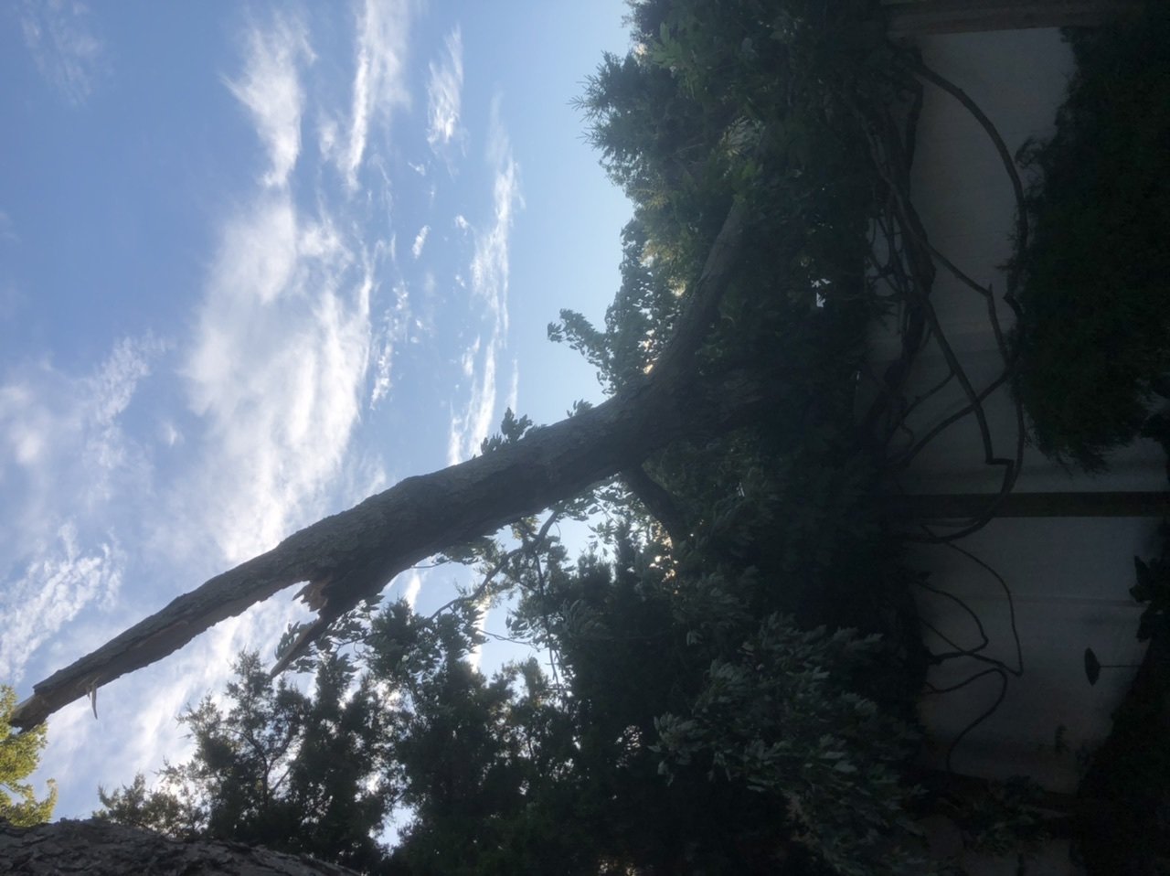
Appears the worst part of what little severe there was east of the city yesterday moved over my area of Lynbrook. Came home from Jones Beach (where the storm was meh) to find a large tree on my neighbors house. The tree had most likely weakened during Isaias as I do not see signs of winds higher then 50ish. Here’s a nighttime pic, but you get the idea. (Norway Maple, weed tree)
-
Tropical connection NYC forum area Fri-Sun 8/28-30/20
LongBeachSurfFreak replied to wdrag's topic in New York City Metro
That would make sense given the track and speed. Basically the opposite of what occurred with Isaias -
August 2020 General Discussions & Observations Thread
LongBeachSurfFreak replied to Rtd208's topic in New York City Metro
It’s been big time boom or bust. Patterns like to lock set and load. It just depends on which side your on. I fully expect some mega blizzards in the future until we become too warm for much snow. That would be 50 plus years from now -
2020 Atlantic Hurricane Season
LongBeachSurfFreak replied to Windspeed's topic in Tropical Headquarters
If there were to be an Atlantic Patricia (and there will be in the next few years) it’s not going to recurve. A storm sub 890 and 200mph plus would occur in the SW Caribbean somewhere near the Caymans. That’s the the only area with MPI to pull it off. So it’s not escaping. -
Excellent video. Peak gusts look to be 80+. Does anyone have a radar loop of the event?
-
Possible FF, Iso SVR NJ-LI Noon WED 8/12-Noon FRI 8/14
LongBeachSurfFreak replied to wdrag's topic in New York City Metro
As per usual, cannot buy a drop of rain on the south shore. Dryness will only act to make the salt situation worse. Meanwhile here on the UWS things are as lush and green as you will see in mid August -
We would have seen a complete destruction of the power grid, with outages lasting months. We likely would have seen gusts to 100mph+ Research suggests that Healthy northern hardwoods fail with winds over 80mph. I paid allot of attention to the tree damage with Isaias and allot of the snapped trees had termite or carpenter ant damage.
-
August 2020 General Discussions & Observations Thread
LongBeachSurfFreak replied to Rtd208's topic in New York City Metro
Hot and sunny on the uws. Bring on the rain later in the week -
Yes it’s awful and a secondary disaster. My parents house is less then a mile from the bay in south wantagh and their huge silver maple is dropping leaves like it’s fall right now. It’s sad
- 1,530 replies
-
- 2
-

-

-
- heavy rain
- rip current
- (and 1 more)
-
August 2020 General Discussions & Observations Thread
LongBeachSurfFreak replied to Rtd208's topic in New York City Metro
That cell in southernmost nj has incredible rotation -
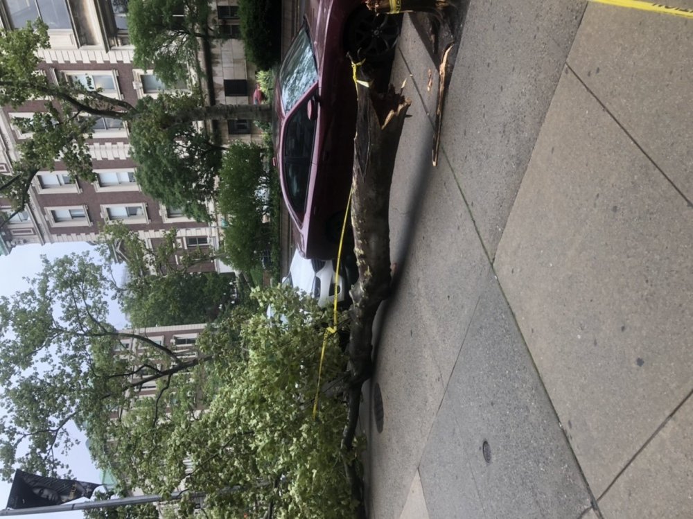
Finally finished cleaning my campus today. I have been driving around on the way home each day and I have to say the tree damage in some areas is on par with Sandy. The Wantagh woods saw multiple oaks split mid way up, and Sandy seemed to be more uproot. Another lasting impact is the salt damage near the south shore. The south sides of trees within a mile of the bay are completely brown. Right on the water and on the barrier islands they are completely brown. I’m sure this will lead to more vegetation loss
- 1,530 replies
-
- 2
-
-
-
- heavy rain
- rip current
- (and 1 more)
-
Sandy. Obvious gloria. A true hurricane with major tree damage and surge Irene. Surge puts Irene on top of Isaias, tree damage similar Isaias. Tree damage but limited coastal impacts Floyd Bob Ernesto It’s only a mater of time before a storm makes all of these look like a walk in the park. I have a feeling we aren’t finished this year
- 1,530 replies
-
- 3
-
-
- heavy rain
- rip current
- (and 1 more)
-
pseg coo just said on news 12 420,000 were out at the peak. i think the biggest factor that made this storm so impactful on trees was the unusual wind direction. Our trees are used to NE/E winds during storms and NW winds during the cold season. My parents enormous silver maple lost 3 huge branches today and did fine during sandy. (Like you said earlier less leaves during sandy)

- 1,530 replies
-
- 1
-
-
- heavy rain
- rip current
- (and 1 more)
-
A couple quick shots from my campus. It’s going to be a long week

- 1,530 replies
-
- 1
-
-
- heavy rain
- rip current
- (and 1 more)
-
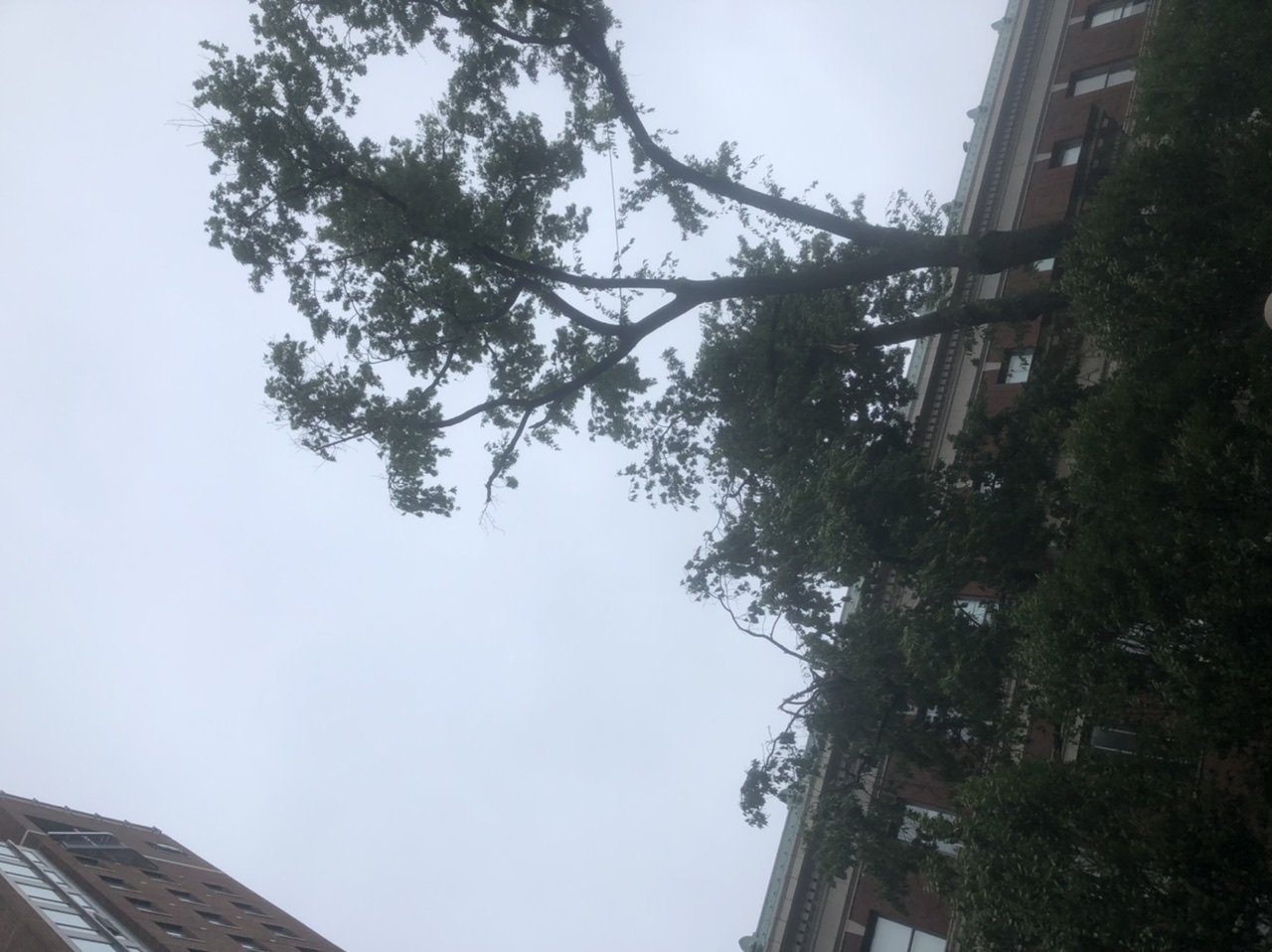
All hell breaking loose in the city, whole trees down on my campus now. We even had windows blow in on the dorms
- 1,530 replies
-
- 1
-
-
- heavy rain
- rip current
- (and 1 more)